by Scot
There has been much whining, history and more whining here and elsewhere about the fact that Interstate 25 between Coal and Rio Bravo has been one of two walls between sections of Barelas, South Broadway neighborhoods (or “East Barelas”), and other parts of town.
To whine and complain without thoughtful solutions is pointless, so with that in mind, let’s toss around a few ideas in coming days to address the situation. Mind you, the solutions here will have the following caveats/biases:
- They will be utterly inadequate in addressing the total scope of the problems created via these walls over the years.
- Implicit and explicit in these solutions is the idea that non-motorized transportation is important, and will become increasingly so in coming years.
To put the two points above into some context, a real solution, albeit still not enough to overcome decades of forced isolation, would be to radically alter the placement of I-25, say, moving it on more of an original El Camino Real 4th St./Isleta Blvd. track.
But, obviously, that’s not gonna happen. Heck, looking closely at the I-25 South Corridor Study, the “S-Curve” between Coal and Avenida Cesar Chavez is still recommended to be left an S-Curve, due to public opposition, logistics and right-of-way purchasing problems. If the single biggest reason to study the entire corridor ends up leaving the single biggest reason fairly untouched, then you’re probably not gonna blow up Civic Plaza to run a new version of the Interstate through downtown. Where’s Robert Moses when you need him (yes, I am being largely sarcastic)?
So with all that adieu, let’s get to Solution #1:
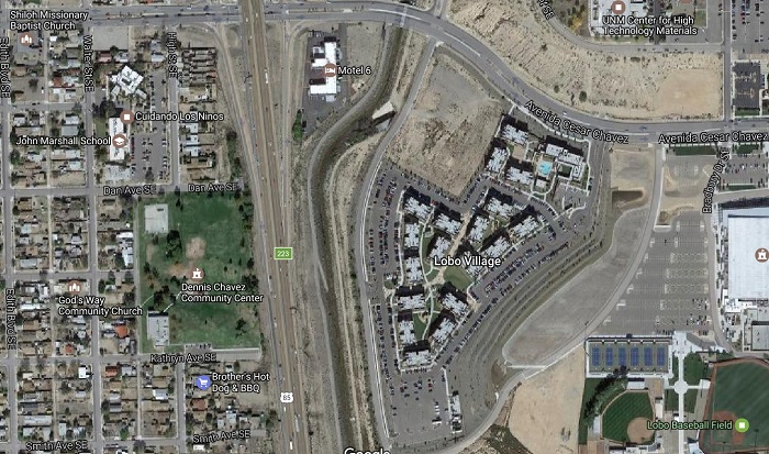
Construction of a walking/cycling overpass extended from Kathryn Avenue over I-25 to the South Diversion Channel and Lobo Village south of Avenida Cesar Chavez.
Why here, and why an overpass? To answer, let’s take a look:
And, in addition to the visual, let’s take a look at some numbers, specifically the Average Daily Weekday (AWDT) Travel figures for Avenida Cesar Chavez at I-25:
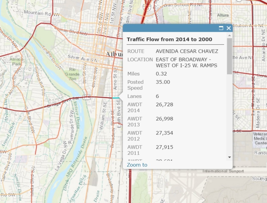
In terms of the numbers above, keep in mind the AWDT at Coal and I-25 is about 9,400. Hell, even the 2014 numbers for Central are only around 20,000. Avenida Cesar Chavez is six lanes, 35 mph (posted) and almost 27,000 cars a weekday of driving craziness. The numbers show just how few choices there are to cross I-25, and some might argue that instead of a walking/cycling overpass, we really need an car-based interchange somewhere around Kathryn instead.
But, there is no way that is going to happen, for myriad reasons, and returning to #2 in our list of caveats/biases, the question for non-motorized users is:
How radically improved would the Avenida Cesar Chavez/I-25 interchange have to be to provide a level of safety anyone but the truly hard-core “strong & fearless” 1% would travel?
The answer is most likely an extremely protected bike lane and sidewalk, fully separated and with barriers from Broadway through the Interchange, and between the Interchange and at least University. And you’ve just got to wonder if that is ever gonna happen.
I, for one, don’t think that’s ever gonna happen. If the AWDT was closer to 15,000, maybe we could snag a lane in both directions and spend some big bucks not only using that lane for bike lanes/sidewalks, but also protected buffers. But not at 26,000. In addition, while I don’t know the right-of-way situation (somebody help me out on that), my guess is that widening enough to keep the six driving lanes and add the necessary walking/cycling improvements would be cost-prohibitive.
So, let’s not exactly give up on Avenida Cesar Chavez. Yeah, we’ll have a six-foot bike lane and maybe snag a buffer, probably with little to no barrier protection. Maybe we’ll get the percentage of non-motorized users up from the .001% it probably is now to a tad over the 1% “strong & fearless” crowd. Whoo-pee…
Instead, let’s spend the $4 million or so it would take to build an walking/cycling overpass at Kathryn, connecting to the pending (and I say pending ASAP) South Diversion Channel Trail and Lobo Village. Taking another look at the bird’s-eye:
Kathryn Avenue clearly shows where it was sheared decades ago to make room for I-25. I’ll have more to say about Lobo Village and UNM in another post. Focusing on advantages for those living in the South Broadway neighborhoods, walkers and cyclists could then:
- Access the pending South Diversion Channel Trail;
- Realistically walk/bike to The Pit, other Lobo sports venues and Isotopes Park
- Avoid Avenida Cesar Chavez and I-25;
- Avoid Gibson Blvd. further south (for the same reasons stated for Avenida Cesar Chavez above, but perhaps even more so);
- Take further advantage of the already great walking/cycling opportunities along Edith Blvd. and other streets not named Broadway in the South Broadway area; and
- Reach some level of equity in terms of such access relative to the other quadrants of town, particularly the East quadrant portion of I-40.
Regarding the last point, it is so blatantly unfair that there are five overpasses/underpasses of I-40 in the Eastern quadrant, three in the Western I-40 quadrant, and only one (correction: two) along North I-25. And no, I’m not gonna count the new Paseo del Norte monstrosity as a cycling/walking overpass. No. Not even.
Still, South I-25 has ZERO.
And while we could have a really fun contest entitled “Worst Interstate Crossing in Albuquerque,” I’d put the current, and honestly, having looked at the plans, future Rio Bravo/I-25 Interchange as strongly in contention for #1 Worst. And it’s the sole crossing between Gibson and Broadway far, far to the South.
Hence, Solution #1 is construct a walking/cycling overpass at Kathryn.
Addendum: And don’t tell me we can’t equitably build overpasses in the Southern quadrant because the costs are so much higher now.
Tough.
We should have thought of that decades ago when we first built I-25. I know the “social justice” card is overplayed, but something has been going on here, for decades, leading to the current situation, right up the fact that no new overpasses are recommended in the latest Corridor Study, and that something has nothing to do with road engineering.

In Seattle, they re-channelized a road at about 25000 AWDT from 4 lanes to 2 and a middle turn lane, with bike lanes added. Throughput actually improved for cars (not to mention a steep drop in people dying and getting injured). 6 lanes at those piddly numbers is just stupidly over-engineered. And if you look at the trends, the numbers are going down, not up. AWDT was almost 40K 15 years ago, with steady declines even in the last 5 years..
Upshot: Of course we can repurpose a lane, and if you do the engineering properly, it will likely be a win-win for everybody. I recommend a two-way protected cycletrack, so you only need 1 lane, and the pushback from behind the windshields will be less.
LikeLike
Cam: I hear you, and know that the needed changes are possible (in italics), but have .0001 faith in them happening here with any crossing involving NMDOT. MLK in its current guise, with “cadillac” bike lanes (for ABQ), yet ridiculously dangerous free left turns to I-25, is evidence of that. Sure, folks in charge can change and bureaucratic cultures evolve, but the timeframe for those changes means, at minimum, a long time. I’d rather do something now, bypass the antiquated thinking, and provide an option that will likely (if SDC gets done, too) lead to more ridership than even the Seattle-level improvements you mention would create.
As for AWDT numbers, the fall you mention is true for a preponderance of roads in ABQ. That our roads still look like they do, despite that fall, illustrates just how much bureaucratic evolution, COA-DMD included, still (in italics) hasn’t happened. – Scot
LikeLike
[…] having proposed at least two walk/cycle overpasses (with more to come) of Albuquerque’s I-25 in the eventual revamping of its Southern Corridor, […]
LikeLike
[…] upcoming 2045 edition of the Long Range Bikeways Plan needs to include bike/ped bridges, perhaps at Kathryn closer to downtown and San Jose Avenue a bit further […]
LikeLike
[…] infrastructure challenges in Albuquerque, as Scot has detailed at some length (see here here here). Scot and I mostly do this on bicycles, but as last night’s Twitter gripe session made […]
LikeLike
[…] BB than anything other than pedestrian fatalities. Namely, you can read about it here, here, here, here, here and […]
LikeLike
[…] That this mindset would seem unshakable in terms of making it far safer for folks to walk and cycle from UNM/CNM/Nob Hill/etc., to/from Martineztown/South Broadway/San Jose/Downtown certainly seems to unfortunately reflect a bit of lingering disregard for the residents of neighborhoods already split apart by the routing of I-25 decades ago. […]
LikeLike