By Scot Key
Relative to our “flash poll” yesterday regarding the new road striping on Girard between Lomas and Indian School, here’s a recent photo taken by occasional Better Burque contributor John Fleck looking northbound on Girard just south of Frontier Ave. (just north of Jefferson Middle School):
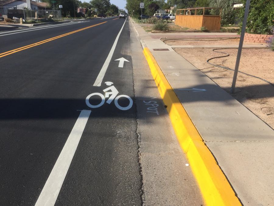
Ouch.
Since this photo first appeared, there’s been understandable ridicule in the “community” of the bike lane stripe interrupted to fit the bike lane stencil. Very understandable ridicule.
Thinking back myself, I recall going to a public meeting, perhaps the last one before work began on the Girard Complete Street Project. You know, one of those meetings with table-tops covered with schematic drawings of proposed project work, and helpful staffers to answer questions.
My memory is certifiably horrible, but I can’t remember seeing any table-top drawing with such skimpy bike lanes. So I went to the Girard Project website and looked at what I do believe were the exact drawings shown at that meeting.
And from looking back at those drawings, and a bit of Google Mapping, I discovered something I certainly didn’t notice back at that meeting, but that seems to have been discovered by plenty of folks now, engineering firms and others involved in implementing the Girard Project included.
From the plans, here’s a cross-section look at the proposed improvements for much of Girard between Lomas and Indian School:
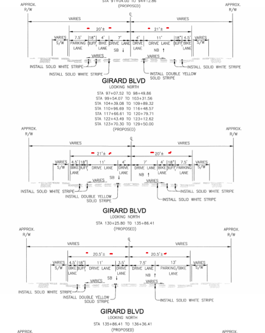
Looking for the little red marks I inserted to aid the eye, we see overall street widths of 41 feet (21/20, 20/21 and 20.5/20.5 respectively). Using that 41 feet, we see a strange 13 foot parking/bike lane section mentioned, but let’s focus more on the two sections that seem to have, to an extent, been implemented in the final project. That’s because if you check out Girard now, there’s one stretch with a parking lane, door zone, bike lane on one side of the street, and a skinny bike lane on the other, with the sides switching roughly midway between Lomas and Indian School.
Now let’s count up the total feet devoted to various elements of the Project:
- Parking Lane: 7.5 feet
- Door Zone Buffer: 1.5 feet
- Bike Lane: 4 feet
- Two Driving Lanes: 22 feet
- Bike Lane Buffer: 1.5 feet
- Bike Lane: 4.5 feet
- Total: 41 feet
Voila! 41 feet. Perfectly matching the 41 overall feet of roadway that unquestionably exists across Girard Blvd. Perfectly.
Only one problem…
It’s cheesy and slightly inexact, but taking a Google Maps bird’s eye view and its measurement feature allows one to measure streetwidths with some precision, while also not being killed by passing cars.
Here’s such a look down at Girard just south of Frontier Avenue.
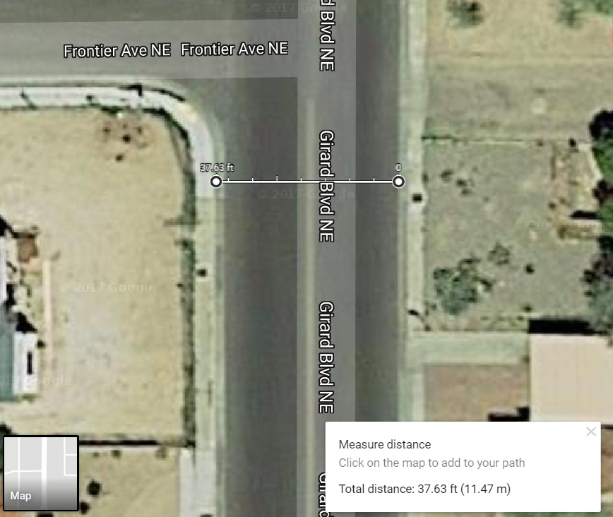
Oh. That’s closer to 38 feet than 41 feet, isn’t it? Particularly, if one counts only one side’s gutter pan (aka “the gutter”) which we’re supposed to do here, as rules call for counting gutter pan in calculating car parking lane width, but not in bike lane width.
But that’s only one spot, Scot! At the very least, let’s take another look at Girard and Mountain:
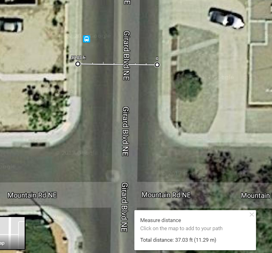
Yes, looking via this method is somewhat inexact, but there is NO WAY Girard is 41 feet across at either of these points, even if you count both gutter pans.
You want confirmation of that fact: Look at the new striping done on Girard.
I believe the term QED is applicable at this point.
Meanwhile, yes, your humble blogger wishes he had known this way back when at the meeting with all the drawings on table-tops. He also wonders exactly when the far more important people in charge of designing and implementing this project discovered this fact.
As we sigh, heavily, let’s look one more time at one illustrative result from this discovery.
Oops.

This is what I tried to recommend over a year ago, after viewing the atrocious designs at the open house. I was told “too late”. Even worse than I imagined.
https://streetmix.net/biliruben1/undefined/girard-from-indian-school-to-lomas
LikeLike
On top of that, Girard at Silver is all but unusable by people who live here. The so called “safe ” place in the middle of Girard is not just inconvenient but downright dangerous. I’ve gotten stuck be hind people doing u-turns so they can get into Silver. Why we could not have the safe convenience of a traffic circle such as at Cornell and Silver is beyond me! I’m disgusted.
LikeLike
Tabitha: Understood on the idea of a traffic circle v. current “diverter,” but my guess is that the high preponderance of Girard N/S traffic v. that on Silver crossing Girard was integral to the outcome.
As for that outcome, the diverter’s inability to thwart the most adventurous of non-compliant drivers, including, I hear, at least one person maneuvering through the curb cuts to go “straight” on Silver through Girard, could be tweaked to the point at which zero folks would try going straight through or around to make outrageously elongated left turns.
Or we could just put another traffic circle there. It’s a worthwhile consideration.
LikeLike
Except that the research shows that traffic circles are actually more dangerous to bikes than nothing at all. So there’s that.
We are not entitled to drive everywhere. Any time. It almost seems silly to type that, but it really seems many folks think they are entitled to just that.
LikeLike
The “research,” and I know there’s plenty of somewhat competing research along these lines, seems to indicate that one-lane traffic circles/roundabouts is safer than the alternative, while two-lane circles/roundabouts is not. I’ll only add that I went through roughly, at least, 250 roundabouts this past Summer in Portugal/France/Germany and I’d trade each and every one of those intersections with ANY in ABQ, right now, any time. And I’m talking traffic intensity as much as in Bordeaux, outside of Lisbon and in the outskirts of Mainz, Germany.
Any of them. Gladly.
P.S.: 250 is probably far too conservative. More like 300, at least.
LikeLike
This is the article I’m thinking of that reports an 8 fold increased risk, when putting in the small roundabouts on local streets (like they did on Silver).
https://www.ncbi.nlm.nih.gov/pubmed/23411678
“Traffic circles (small roundabouts) on local streets increased the risk of these otherwise safe intersections (adjusted OR 7.98, 95% CI 1.79 to 35.6)”
It appears well designed, in a peer reviewed journal, with good analytic methods. I’d love to see the competing research that says otherwise.
LikeLike
And if anecdotes hold stronger sway for you, I’ve been through literally 1000s of these kind of circles over the last 20 years, and have had dozens of near misses and been hit once. It’s the default infrastructure all through Seattle for uncontrolled intersections. Humorously, I was hit by an orthopedic surgeon, who I then accused of trying to drum up business. Fortunately I was able to maintain my health and my sense of humor.
LikeLike
But what I will give you is that they likely do decrease the severity of injury due to slower speeds. So you are hit more often, but you will likely survive it.
LikeLike
[…] observant BB reader relates that it’s right there on the cross-section drawings shown in an earlier post. As circled above, the bike lane width of 4.5′ in the Girard Complete Streets plan definitely […]
LikeLike
I am a life member of the League of American Wheelmen(Bicyclists) and a bus driver who drove the route that incorporates this street. It is a nice street on the south end near the golf course and airport, but the rental properties closer to UNM force residents to park vehicles on the street. Right in that bike lane….problem??? What kind of bike lane incorporates stationary vehicular barriers, not to mention the trashcan slalom that occurs each week on pick up day? I don’t see how this works in any way, shape or form. Good luck.
LikeLike
[…] only be here because of it, Mike Bevilacqua at Bicycling.com published an essay yesterday about the ugly new bike lane on Girard Blvd., linking back to that fabulous John Fleck photo of said ugly lane. It’s such a great and ugly […]
LikeLike
[…] Key, of the local urban planning blog Better Burque, has a good rundown of what may have happened with the lane’s bizarre engineering. The gist, for all you wonks out […]
LikeLike
[…] In the “You think that’s narrow? Hold my beer…” department, visual documentarian of all things Girard Complete Streets Project, John Fleck, has captured an even skinnier bike lane than was posted at BB around ten days ago: […]
LikeLike
[…] first glance, it might appear that Girard Blvd. is having its skinny bike lane fixed, but that job is, at least for now, not the reason for the lane closure […]
LikeLike
[…] a positive for those advocating for a wider bike lane, but a bigger, long-term positive is that the Girard Project saga offers hope, a lesson, and a precedent in how we might proceed as a community in making roadway […]
LikeLike