Last night’s meeting of the Greater Albuquerque Bicycling Advisory Committee featured an alluring enticement to help spend some federal funds matched by a bit of CABQ money.
In short (because the long version would either put you to sleep or make you head hurt, or both) “we” have right at a million bucks ready(ish) to spend toward fixing a current gap or deficiency in ye olde bicycle facility infrastructure. Discussion of this last night ended with that David Letterman and internet staple: The Top Ten List.
So, let’s put together a Top Ten List of how we can spend that money. First, a few rules and parameters:
- The project has to be within the city limits of Albuquerque (no County)
- We’ll prioritize the order of this Top Ten later (because that’s the hardest part)
- For now, we’ll disregard the typical hang-ups that make fixing anything concerning cycling infrastructure damn hard, (e.g., right-of-way, whether the work is in Brad Winter’s Council district, etc.).
So in no particular order and without the internet “listicle” page-by-page clicking…
1: Parking-Protected Bike Lanes on Coal and Lead downtown, 2nd to 8th: Better Burque is lazy, so let’s cherry-pick a bunch of projects that have already been proffered, vetted, designed and such. Besides, maybe we’ll save a bit of money that way. Design plans for parking-protected bike lanes in this stretch were done way back in 2016, yet we’re still stuck with a fascinating, and highly dangerous mix of “legacy” striping on both Lead and Coal (check ’em out sometime). Let’s spend a million (or at least a chunk of it) making this happen.
2: Full Complete Streets-DPM compliant bike lanes on San Pedro from I-25 to the north all the way to Gibson: Speaking of “legacy,” San Pedro Blvd. in its entirety is a veritable museum showcasing the history of cycling infrastructure. We go from the pretty much state-of-the-current-art treatment from I-40 south to just north of Lomas (buffered wide lane) to 1980s/90s skinny lanes of 3-feet or less width at several places, including just south of Paseo del Norte, to no bike lane whatsoever along the Fairgrounds and in the far north toward I-25. It’s a hodge-podge that needs to be de-hodged and thoroughly un-podged. Road dieting San Pedro ala the “good stretch” would be best at many junctures, including alongside the Fairgrounds, while widening pavement in bits toward I-25 would provide sufficient room for fully DPM-compliant bike lanes there.
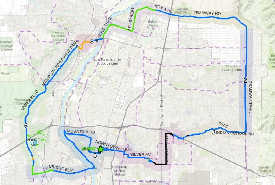
3: Connecting gap(s) on the I-40 Trail, west and/or east of the Big-I: I can’t find it this morning, but somewhere there’s a CABQ promotional webpage announcing that cyclists can ride trail along I-40 all the way from the far West Mesa to Tramway. Umm..no you can’t. A page from CABQ outlines how one can ride this distance, but it, of course, includes many places where riders must leave I-40 and meander through various detours. What if we fixed at least one of these gaps?
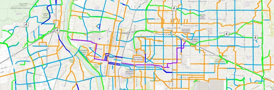
With so many gaps, picking one to spend a million on is hard, but let’s go with making it possible to go from the Bosque Path to, say, Edith Blvd. without having to drop down to Aspen around Rio Grande Blvd., get killed crossing Rio Grande Blvd. (a daunting prospect) and safely make it through the numbered streets to Edith at the western base of the Big-I.
Okay, maybe we should pick an easier gap.
How about connecting the current gap between Jerry Cline/Winrock and Los Altos Golf Course. Yeah, we’ll start with that easier one.
4: Taylor Ranch/La Orilla at Golf Course: Picking a Top One Worst spot on the City’s 50-Mile Activity Loop is tough…
Is it crossing I-40 on Unser? Is it the very-soon-to-be-mentioned-here crossing of Coors on Eagle Ranch? A very tough question, but the scene below is certainly one of the worst:
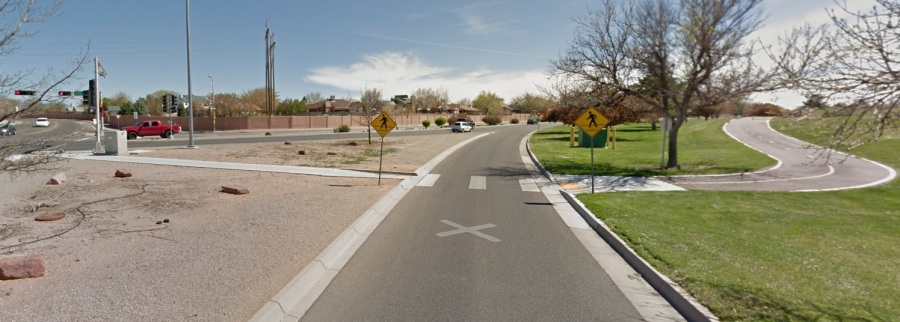
It’s tough to take in all the awful at this intersection, but via Google Streetview, we’re standing in the above photo directly in the middle of the “slip lane” (not advised, by the way) as the multi-use path at Mariposa Basin Park enters the conflict-point-filled hell that is Taylor Ranch/Golf Course/La Orilla. Fixing this intersection for all users, particularly walkers and cyclists, will involve many improvements, including elimination of this “slip lane” we’re virtually standing in above.
The best spending of our million dollars here would be to first buy a bunch of dynamite and blow the whole thing up. We can call that the “traffic calming” interim before we reconstruct this danger spot sans “slip lanes” and other dangers. Let’s also be sure to take plenty of photographs here as reminder as to what NOT to do when originally constructing complex multi-modal intersections (and they should all be multi-modal).
5. That Bike/Ped Bridge over Coors at Eagle Ranch That Didn’t Get Built: A bit further north and east of #4 along the 50-Mile Activity Loop we come to the intersection of Eagle Ranch and Coors.
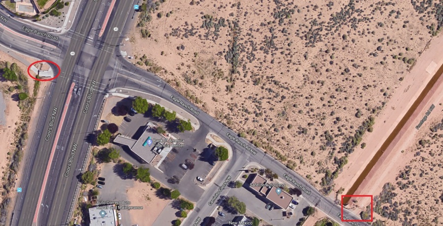
This section of the 50-Mile Loop is a great example of a short, but huge, cycling infrastructure gap. In the above satellite view, to the left we see the end of the multi-use path as it approaches Coors Blvd (red circle) and to the right/east a red box where a brand-spanking-new paved multi-use path now extends from Eagle Ranch north to SIPI road. That multi-use path is so new it’s not on this Google satellite shot.
So, cyclists/walkers have this multi-use path to the west and fabulous new way to avoid Coors Blvd. to the east, and then there’s getting between the two. It’s great, until it’s not.
It has been repeatedly proposed that the only/best way to solve this gap is through a cycle/walk-only bridge over Coors Boulevard. Such a proposal now makes more sense than ever, given the new path. Will it cost more than a million bucks to do this? Let’s worry about that when the time comes. Speaking of time, I wonder how much we would have saved by building it back when the idea was first proposed…
_______
These five ideas put us halfway through our Top Ten List of ways to burn through a million bucks. We’ll finish our Top Ten in an upcoming post. In the meantime, what do you think would be the best use of a million dollars for Burque cycling improvements? Readers will note a comment box below. You can use that, in case you didn’t know. To send, like, comments.
Looking forward to reading those million dollar ideas.

There is a 2000 ft stretch on El Pueblo Road from the North Diversion Channel Trail to Lorraine Ct. NE that is such an annoying gap. There are several parts with no shoulder at all, a rough railroad tracks crossing and where there is shoulder it is messy and uneven. So you have to take the one and only lane with no passing.
It is unfortunate because it leave a gap in the multi-use trail along paseo and disconnects the east side and Journal Center area from the Journal Center rail runner station and diversion channel.
LikeLike
Another idea is to take the north diversion channel trail from the balloon fiesta park all the way to Edith. It would be nice to connect it to Roy or 4th street, but that would require county/pueblo work. I think connecting it to Edit though is all city land.
LikeLike
Chris: Thanks for the input. Solving the “El Pueblo Question” is probablyl the single-most requested fix in town, and, as you may already know, almost definitely the single-most maddening overlap of jurisdictions and buck-passing (NMDOT/City/Different City Departments/etc.) Given the bureaucratic mess there, ideas on alternatives such as paving N. Pino Arroyo a bit south on the north side to Tiburon have been raised (okay, that idea has been mainly raised by me).
As for extending the NDC to Edith, that’s another great idea, and would be City throughout (and AMAFCA). I’ve not yet heard the reason why it wasn’t extended thus in the first place. Good question to ask until we find the actual answer. Last time I rode Roy I seem to recall seeing new fencing trying to make it harder to access Roy from Edith below. Reversing that to make it easier instead would NOT be City, but just connecting NDC to Edith would have advantages. – Scot
P.S.: Anyone wishing to get clearer info on City Limits and some other details can find it at: http://coagisweb.cabq.gov/Html5ViewerGeo482/Index.html?configBase=http://coagisweb.cabq.gov/Geocortex/Essentials/geo482/REST/sites/Public_Zoning_Viewer/viewers/Backup_of_Public_Zoning_Viewer-Advanced_Map_Viewer_20/virtualdirectory/Resources/Config/Default
LikeLike
[…] look at a Top Ten list of Burque cycling infrastructure gaps, an exercise based on the fact the City will shortly have roughly one fed/local match million dollars to spend toward addressing at least one such […]
LikeLike