Question: What’s the longest continuous stretch of ABQ cycling roadway infrastructure that is truly LTS 1 or 2?
I raise the question after recently posting this photo of the brand-spanking new Woodward Blvd. eastbound as it rises to meet I-25
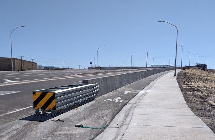
That wide, solid (apparently) concrete “Jersey Barrier” separating cyclist from driver (along with cushioning metal contraption to save Driver X when they head for the Jersey Barrier head-on) is the first such, very real, physical separation in the entire area, as pointed out by an alert BB reader (they are ALL very alert). Said reader also pointed out that it’s a darn shame that cylists safely toodling up the hill eastbound along this Jersey Barrier eventually get to I-25 as Woodward turns into Sunport Blvd. where they run into this:
Yes folks, that is a crosswalk terminating in a little concrete box next to a cactus. No more Jersey Barrier. No more separation of any kind. Welcome to the Albuquerque Sunport. Oh, and, just for added flavor crystals in this delicious breakfast of cycling hell, there’s also that slip lane with Guy in Black Sedan above desperate to make their plane on time exiting I-25.
In other words, one does not need to look anywhere else to find ABQ’s nexus of the absolute best cycling roadway infrastructure in town and worst cycling roadway infrastructure in town. It’s right there at Woodward/Sunport eastbound over I-25.
Which gets me back to the question: What’s the longest continuous stretch of ABQ cycling roadway infrastructure that is truly LTS 1 or 2?
We’re talking roadway, so Bosque Path, North Diversion Channel, etc. don’t count. And while we all have our own personal idea of what constitutes LTS 1/2 versus LTS 3, I’ll throw out my own interpretation which is to add that you, alert BB reader, would suggest said continuous stretch to any new/relatively new cyclist, whether they were a friend, colleague, family member, or just a reader of your blog.
In answering the question, I went to the ABQ Bike Map looking for blue bike lane designations. Having ridden pretty much all of these roads/bike lanes (because I’m weird that way), particulary those not on the West Side north of I-40, I just start rattling them off with a quick yes/no in terms of whether these are:
A. LTS 1 or 2 bike lane roadways in the first place
B. If/where the major road crossings along these bike lane roadways stay LTS 1 or 2
As you are an alert BB reader, you’re probably thinking that achievement of criteria “A” above is hard, but not impossible. Achieving criteria “B” in this town IS damn close to impossible.
So, just to pick a starting place, let’s first go south/north east of the River running for roads going east/west:
Gibson: No
Zuni: No
Constitution: Yes, but not at major crossings
Indian School: No (this one is closer, but not at the major crossings, and I’d argue it’s a No all the way)
Candelaria: Closer, but No
Comanche: No
Montano: Hard No
Osuna: Arguably yes (35 mph), and the major crossing are pretty far apart (San Mateo – Wyoming)…let’s remember this one
Spain: No (the bike lanes are too narrow)
Academy: Hell No
Alameda: No
Being the good teacher that I am, I’ve got us started and it’s now your job to finish evaluating all the other bike lane roadways in town. Or you can be lazier and just attack my Yes/No determinations above. My overriding contention through this process is we’re gonna find damn few, if any, truly LTS 1/2 stretches that extend beyond the limitation of major crossings. For instance, I’d certainly tell New Rider X they should feel comfortable riding Constitution between Girard and Carlisle, heck they can even start off at UNM North and should feel safe east until Carlisle. Then there’s Constitution at Carlisle.
So:
- Look the bike map over
- Find what you consider the longest stretch of LTS 1/2 in town
- Use tools to measure the length of that stretch in miles
- Present your findings
Will we get a stretch that longer than 2 miles? I’ll put that out as an early Over/Under for wagering purposes. I’d think I’d take the Under.
Thanks for playing!

Does the bike path along Paseo not count since it’s not on the roadway? What about the “multi-use trail” instead of a sidewalk on Alameda from Edith to Jefferson?
LikeLike
Constitution has a significant gap west of San Mateo plus, of course, the fact that it’s every rider for herself and cars above all at every major intersection w our car culture’s beloved right turn on red without even slowing down practice
LikeLike
Keep the clarifying questions and comments coming, folks. Zach: Those MUPs/faux MUPs are a tough category (I’d say “No” on the Alameda and “Yes” on Paseo) but are similar in that safety ends at the crossings. So let’s say “Yes” to both and you calculate the mileage between those crossings. I don’t think we’re up to two miles yet.
S. Hering: Can definitely see your point about Constitution west of San Mateo. These are all judgment calls, even when invoking “science” like posted speed, daily traffic, etc. That bike lane drop-off west of San Mateo is truly weird, is it not?
LikeLike
By the linked definition of LTS 1: “LTS 1 also applies to multi-use paths that are separated from motorized traffic.” I would say the “roadway” MUP (if that is not roadway infrastructure, then what is it?) running along the east side of Tramway for 8 miles from just north of I40 to the County Line Barbeque is pretty lengthy. But then, does “continuous” mean “unbroken by controlled crossings?”
LikeLike
Good point, Roger. I’d say continuous does not mean crossing Montgomery on that Tramway MUP. From the crowd of faster folks riding the shoulder instead of the MUP, I’d say I’m not alone in that thinking. I know the slow folks/dogs getting walked are an issue, but those crossing are a big/bigger one.
LikeLike
And of course the new Sunport bridge is a county project. My guess? There’s a plan to connect the Bosque Trail to the Sunport with protected infrastructure all the way. I’ll see what I can find out. Did you see that the Sunport is looking into installing more & better bike parking? Of course they have to “study it” first. But maybe a miracle will happen and we’ll get some bike lockers within the next year.
LikeLike