Due to safety shortcomings in ABQ’s/BernCo’s cycling network, such as it is, many of us drive to the Bosque Path or other area multi-use path, take the bike out of the vehicle, and ride that path.
Over and over and over and over.
This is nothing wrong with this, other than the safety shortcomings in our cycling network, but perhaps you have been driving out and riding the same path over and over and over and wanna try something new. Maybe something a bit less crowded than the Bosque Path. Maybe something extremely off the beaten path.
Boy howdy, do I have an idea for you.
What if you saddled up the bike(s) in/on the car/behemoth and made the scenic drive south towards…

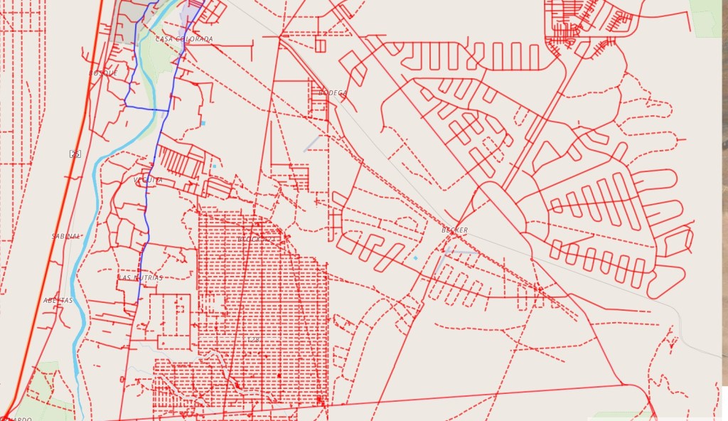
“What the Hell is that and where the Hell is it?” you’re probably asking. Realizing the tech situation between viewing the above on a phone, sizing in general, your possibly deteriorating eyesight, and other factors, I’d suggest those interested blow up the image above as much as possible and scan for almost-petrogylphic looking “roads” etched in strange patterns throughout this veritable middle of nowhere.
We’re gonna ride these roads.
Before we get to the question of “Why the Hell would we ride these ‘roads’?,” our brief answer to the questions of what/where the Hell starts with this:

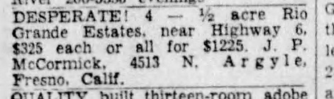
Back in 1960, the “Horizon Land Corporation” bought 100,000 acres of pretty much everything immediately south of Isleta Pueblo and east of Los Lunas/Belen south down to U.S. 60 and further east out to the Manzanos from Gen. Tom Campbell, “famed Montana Wheat King.” Horizon then flooded newspapers throughout the country with ads such as above for “Rio Grande Estates.” And advertising being what it is, people from all over the country bought thousands of half-acre, acre, and multi-acres lots, sight unseen, not quite realizing that being “32 miles from booming Albuquerque” could seem much, much longer.
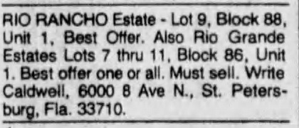
Very long story deserving of several blog posts short, while some houses were built on Rio Grande Estates and other “Rio Communities,” the sorta-kinda municipal term we use today for the northern reaches of Gen. Campbell’s 100,000 acres, many more lots turned into transparently frenzied ads over time in Albuquerque newspapers from folks all over the country.

Nevertheless, Horizon did construct many, many “roads” throughout Rio Grande Estates and its even more remote sister adjacent south, “Tierra Grande.” One big reason for this was that Valencia County ruled they wouldn’t plat the lots UNLESS Horizon constructed these roads. Funny sidenote: Valencia County had to buy a $10,000 computer (one can only imagine how large this computer must have been in those days) to handle the spike in plat requests and related matters.
So today there’s acres and acres and acres of arid scrubland criss-crossed with these “roads.” Full Disclosure: I have not ridden these “roads.” Yet. And a look at the Strava Global Heatmap, which tracks routes of all public rides by Strava users, indicates that zero Strava users have ridden these “roads.” But if you’re looking for a low-stress, less cycling-crowded alternative to the Bosque Path, this makes it a feature, not a bug.
Right?
For added incentive, some of us play silly GPS games where you get “credit” for riding places for the first time. One of these games is “Wandrer.” In Wandrer parlance, roads and “roads” you haven’t ridden show up in red (roads you ride show in blue). Solid red lines are, supposed to be, paved; dashed red lines are dirt roads/paths/cattle tracks. Here’s what the same stretch of Rio Grande Estates/Tierra Grande looks like in Wandrer.
Well shit we gotta ride that!
If you squint you can see the only blue, for me, in the entire map above, a stretch of NM-109 through Jarales and NM-304 up back to near Belen that I wrote about a while back. In the parlance, there’s miles and MILES of Wandrer to be had, much of it allegedly paved.
Disclaimer: I do not know if these designated paved roads are actually paved. Also, there is not tree one for shade ANYWHERE in 99.9% of the red outlined above. Very, very few people, it turned out, wanted to live in this area. Just about nobody has ever cycled this area. I also imagine that if the wind is blowing, say 5 mph along the Rio Grande, it is blowing approximately 95 mph through Rio Grande Estates and Tierra Grande. Be advised.
So while this is a stupid idea that nobody, including me, has ever tried, my suggestion is that you load up the bike, drive to the parking lot of Valencia HS at the northern end of this sea of Wandrer red and ride south through as much of the solid red line segments as possible before you die from dehydration and heat stroke and/or are blown off the bike by the wind.
Seems fun, right? Definitely a change of pace from another slog up and down the Bosque Path.
