
Here’s a visual trivia contest question that pretty much every cyclist in town and many, many walkers would get right in a nanosecond while 99.8% of the “normal” (i.e., not walkers/rollers) population would be stumped.
The Question: Where is this and why is it a hugely important transportation spot?

Okay, the title of the blog post might have been too strong of a clue. That admitted, pretty much any cyclist in ABQ wouldn’t need the blog post title. Which is saying something because there’s no sign, arrow, or anything noting this spot beyond the nice blue, yellow, green circle thing on the left, which I’ve always thought was graffiti.
Yes, we are approaching Yale Blvd. at the edge of the parking lot for where UNM employees get their office keys and a branch of NUSENDA Credit Union. More to the walker/roller point, we’re leaving the relative safety of the North Diversion Channel multi-use path and UNM/NUSENDA parking lot to brave the maelstrom that is Yale and Lomas Blvd just ahead to the south.
We don’t know how many walking and rolling folks use the little concrete ramp next to the blue/yellow/green circles each day, because we don’t count stuff like that. But it is a lot. Ask just about any cyclist in town and the many walkers/rollers who get to/from UNM after parking in the lots up toward KNME on University Blvd. They’d all probably say “a lot.” Followed by, “I don’t know. We don’t count that stuff.”
A perhaps more compelling piece of evidence comes from taking a look at the Yale/Lomas intersection on Google Streetview.

Just as is the case with the latest “view” in February of this year, pretty much every prior view (e.g., December 2018) has someone waiting for that light to change on Lomas so they can walk or roll across. And most folks do try to cross on the left side of the intersection, as shown above, for a bunch of reasons very much including that little concrete ramp by the blue/yellow/green circle thing.
Of course, on the right side of the intersection across Lomas is the corner of the newly expanded University of New Mexico Hospital. Natalie Robbins at the Albuquerque Journal tells us that this expansion cost $842 million.
That’s a lot. That damn close to a billion, and “billion” is a word almost never used together with “New Mexico.” In fact, the UNMH expansion was the extremely rare case of a New Mexico “multi-crane job.” And here we don’t mean of the Sandhill variety.
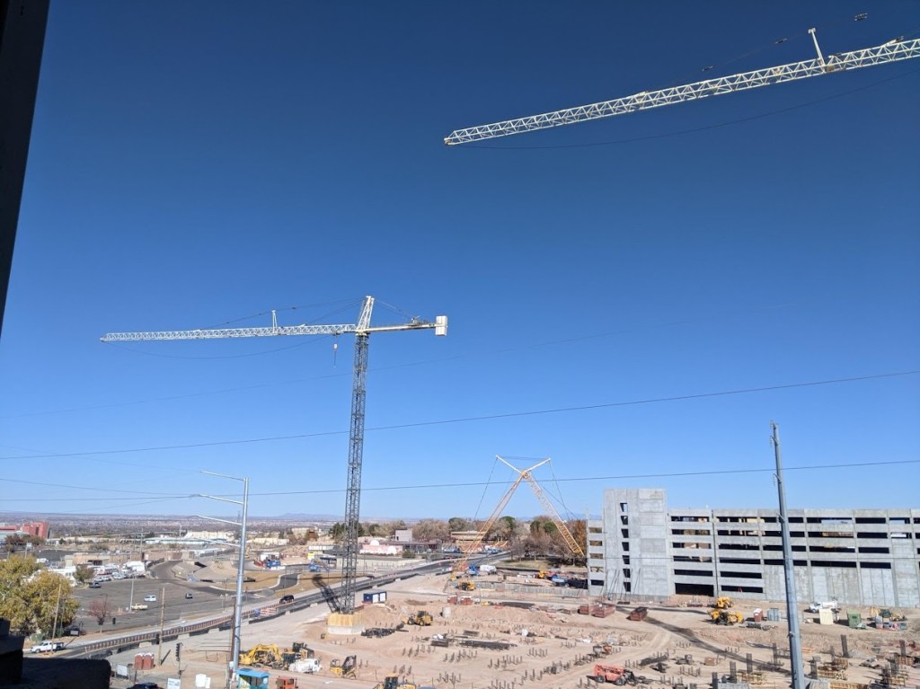
The above photo was taken four years ago on 11.21.21. from the parking garage (one of them) across Lomas from the Hospital. That’s four years of construction and four years of walkers/rollers living through an ever-changing, oft-confusing, and often downright dangerous series of what the federal Manual on Uniform Traffic Control Devices (MUTCD) calls “Temporary Traffic Control Plans.”
In layperson’s speak, we’re talking signs and other means put up during construction to get people safely around the construction. Maybe we should put the word “safely” in scare quotes, because these Plans often, in practice, don’t offer much in the way of safety. Here’s an example of what one such “Plan” (maybe that word should be in scare quotes, too) looked like (in this case May of 2021):

and let’s zoom a bit to get a better idea of what’s going on here…

Yeah, that’s a person forced to walk on Lomas Blvd. because construction fencing is up along with barricades and a boatload of signs including “Detour” all across Yale, sidewalk included. Raise your hand if you ever had to walk/roll where the person above is during this “Plan” of Temporary Traffic Control.
Which gets us to an even more obscure visual trivia question: Where is this and why was it hugely important in May of 2021?

I’m really making you think on this one. Even you hard-core walkers/rollers. Take a minute to think. I can wait.
Time’s up!
This haphazard mass of jersey barrier, crime scene tape, orange cones, and signage is located between the parking lot mentioned above and the NUSENDA Lomas branch drive-through exit. It was THE place for walkers/rollers to access the stupidly dangerous “Plan” concocted in which the person (and perhaps you) walked/rolled in the right westbound lane of Lomas Blvd, feeling incredibly dumb and unsafe in the process.
This “Plan” was in place for a while, and I can’t remember/count high enough to list all the “Plans” instituted through the four years of construction. The upshot was/is that walkers/rollers using Yale/Lomas have gone through a lot of dicey experiences over the past four years. And as we’ve already proven, there are a lot of walkers/rollers at Yale/Lomas.
So, $842 million and four years of inconvenience/danger later, what safety improvements have walkers/rollers trying to cross Lomas at Yale Blvd. been rewarded with via a new intersection?
We’ll dive into those improvements in our next post, although the title of this post already gives too much away. Still, the next post will have more photos and everybody loves photos.
