
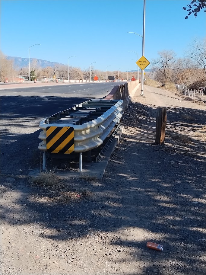
Residing in the far South Valley hinterlands beyond Rio Bravo Blvd, we locals go “to town” quite a bit, as the far South Valley doesn’t have much in the way of “town.” Myself a cycling local, the photo above shows an extremely important bit of active transportation routing that I take two or three, sometimes four times a week.
No, I’m not referring to eastbound Rio Bravo Blvd., empty of vehicles in the photo above but usually chock-full of drivers treating the Boulevard as a highway or raceway. A Paseo del Norte of the Sur, so to speak. Instead, I’m talking about the small gap you see between that Rio Bravo Blvd barricade and the little wooden post/bollard to the barricade’s right, leading to the faint trail you might spot running east along the stroad toward the Rio Grande River.
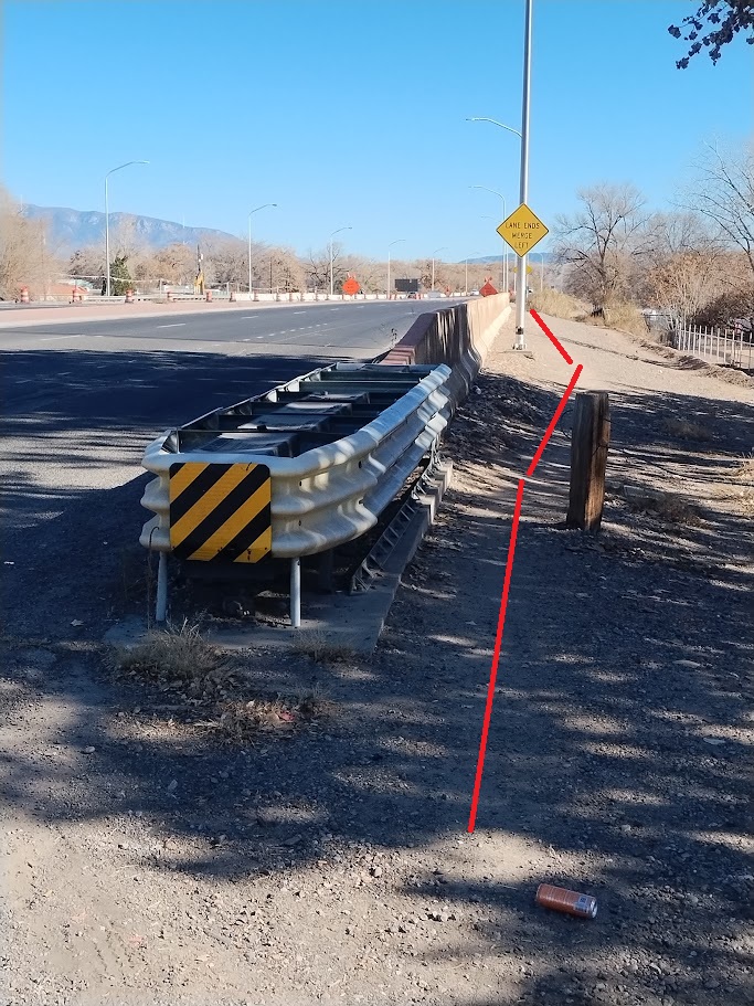
In case it’s too small for whatever reason, here’s that route in red.
I’d guess this narrow dirt path hosts at least 100 walkers/rollers a day (probably more), many of them many walking to and from Joy Junction shelter on 2nd St. a bit south of Rio Bravo to the gas station, fast-food, and grocery store at Rio Bravo and Isleta Blvd. I come across one or more folks on the trail pretty much every time I’m on it, each of us courteous to make room for each other.
The path as de facto “protected multi-use path” seems to me a very good example of active transportation users coming together to further self-preservation among its members without, and despite, government action, public meetings, etc. This path is NOT on the City’s 2025 Bike Map. You WON’T find it when constructing a route in the very excellent RidewithGPS.
It’s an underground route.
For quite a number of years, your humble blogger has been all about urging government and the larger community to elevate walker/roller status and safety on the roads. E.g., if we have driving lanes we MUST have bike lanes! Any new road construction MUST integrate walker/roller infrasructure in its newest/safest iteration! Why MUST those not driving be treated as outsiders and freaks!
While I still think so, and will still do things like attend this upcoming Lomas Blvd public meeting and pester consultants and City folks in attendance that they MUST do more for walkers/rollers on/adjacent to Lomas, it is also true that my personal interest and cycling love for underground routes has grown tremendously in recent years.
Thus, my heart was positively a flutter, and a tiny bit conflicted, when my riding buddy and I first came into contact with this about a fortnight ago:
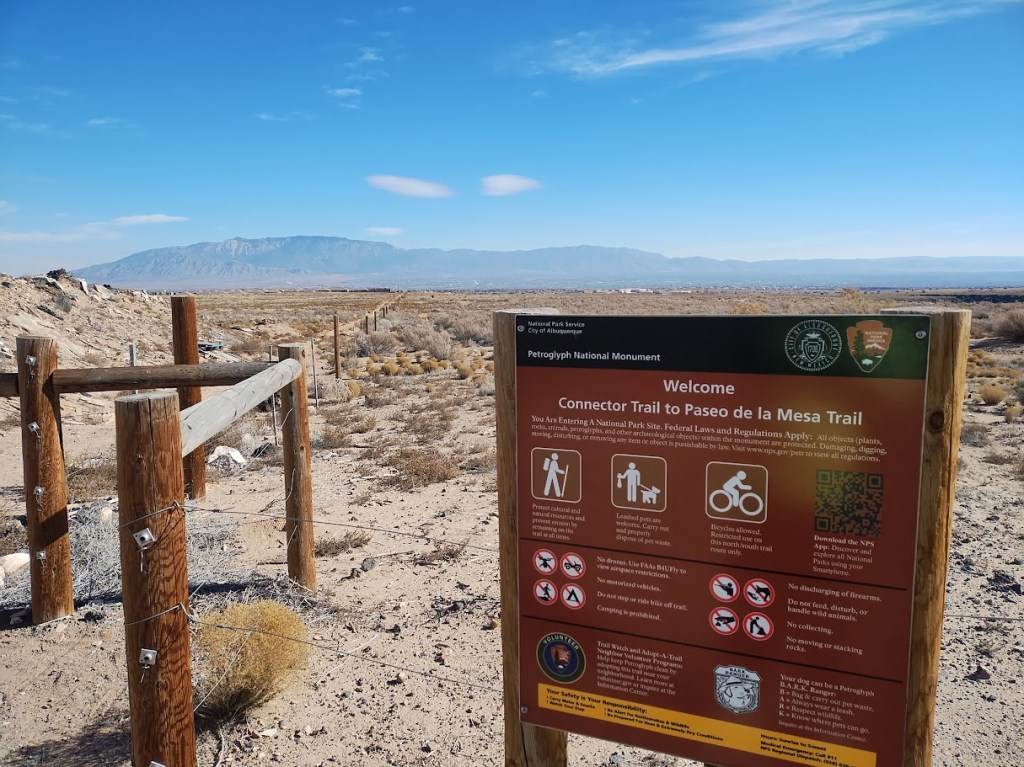
To answer the trivia contest question brought up last time I shared the photo, the sign and entry point shown above can be experienced roughly where the crude red dot is on this doctored screengrab:

I know for most of you the bird’s-eye above is well nigh useless, but, to simplify, you can probably spot the green and dark blobby parts that are the River and civilization near the river and then a ton of brown, and that the crude red dot is way off in the middle of the ton of brown. We’re talking way out there, in this case to the north and west of Volcano Vista HS/Tony Hillerman MS and just south of both Paseo del Norte (as it heads west toward its southern bend and name change to Arroyo Vista) and a bit south of Ventana Ranch.
More to the crude point, the crude red dot is at one of the many boundaries between the old Black Ranch and Petroglyph National Monument. The City’s paved Paseo de la Mesa Trail zig-zags west and north from the neighborhood next to Boca Negra horse facility and George J. Maloof Bothersome, Noisy Model Airplane and Drone Flying “Field.”

This Connector runs straight north from the Paseo de la Mesa Trail as a dirt path strikingly similar in appearance to that underground path along Rio Bravo Blvd. A tiny bit of research done by somebody other than me seems to indicate that this Connector Trail has been a very informal underground trail for quite some time, before being formalized with the sign and the fancy gate/fence and all of that more recently.
The Connector is very important, as it allows walkers/rollers to avoid unfriendly Unser/Rainbow Blvd and adjacent civilization as extension from the relative safety of the multi-use path running up Boca Negra Canyon from Unser Blvd. It’s SO important that a bunch of locals created it, from nothing but sand and scrub, as an underground route.
That is a beautiful thing.
I applaud those early underground trail “developers” who started riding through the sand and scrub, maybe following a route carved by Black Ranch sheep and cows decades ago, maybe not, just as I admire the first adopters on the dirt alongside Rio Bravo Blvd. The only difference between the two paths is that the “Connector Trail to Paseo de la Mesa Trail” has a title (with the word Trail in it twice), an impressive sign in federal government brown with U.S Government and City of Albuquerque official seals, and one of those go this way and then go this way fence gates to thwart ATV drivers.
“My” underground trail along Rio Bravo has no such title, sign, or gate.
While I absolutely love the “Connector Trail to Paseo de la Mesa Trail” and plan to ride it many, many times now that I’ve found it, and am in simple awe of the evident perseverance and patience exhibited by folks willing to advocate for the Connector’s formal status despite the huge bureaucratic barricades of both federal and city government, I find myself preferring the untitled, unsigned, ungated dirt path alongside Rio Bravo.
And not because it’s the one I use two or three, sometimes four times a week.
Happy active transportation weekend, everybody. Hope you find an underground trail or two along the way.
