Editor’s Note: Today’s post was written by Charlie Otto, the co-founder and former owner of Grand Teton Brewing in Wilson, Wyoming, and Victor, Idaho. Charlie began bicycle touring in 1979. Since then, he says, “I have taken more than 25 trips of a month or longer across the United States, Canada, Europe, South America, Cuba, New Zealand, and Thailand with conditions varying from separated, paved bike trails, to off-pavement wilderness dirt routes.”
A lot of non-cyclists we talk with in Albuquerque have lots of reasons why they don’t cycle, but the one we hear most often is “the streets are just too busy, people just drive too fast.” I can hardly disagree. But we try to explain to these folks that the streets and pathways WE bike on are usually not the ones YOU are driving on.
There is a whole network of pathways and quiet bike routes here in Albuquerque for the cyclists. It’s just a matter of finding them. The propose of this article is to give you more tools to be able to make better choices about the routes you cycle so you are safer and have a less stressful, more enjoyable adventure on your bike.
The ABQ Bike Map – online and on paper.
Once a year the city of Albuquerque updates and prints its paper bike map showing all of the bike trails, lanes and routes in the city. It is a great resource that every ABQ cyclist should have whether riding for recreation, commuting or running errands. You can view it on your computer here.
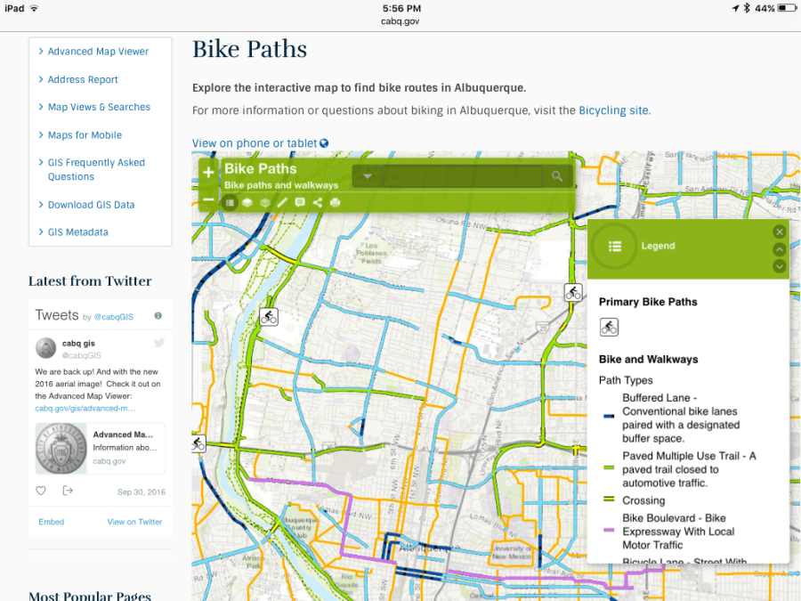
Most area bike shops have the hard-copy map (they are free) or you can get one by calling 505-768-2680.
Digital Maps – online and on your smart phone
With so many new bike routes being developed all the time, it is becoming difficult for traditional paper maps to stay current. And though traditional paper map users might think diving into the digital mapping world is daunting, the advantages are many and it is well worth the plunge.

Google Maps is familiar to most of us, being easy but only somewhat useful. It is an interactive map, and, with the built-in GPS, shows you a map of where you are as well as bike paths, lanes and routes as thin green lines. If you choose a location you would like to travel to by bike, it uses an algorithm to map out a route for you. In theory this is good, and it is getting better all the time; however, sometimes its choice of cycle routes has more traffic than I like. Also, Google Maps little green lines do not give me enough information about what type of bike infrastructure is actually on the ground. For these reasons I prefer mapping my own routes using the bike path network and quiet streets.
OpenCycleMap
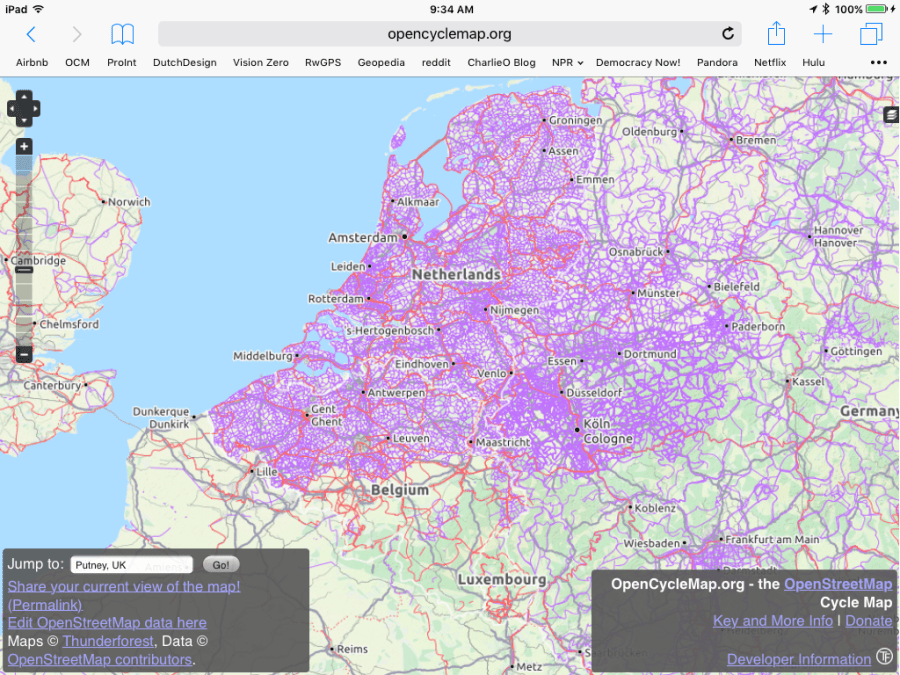
What if there was an interactive, digital map of almost every official bicycle route that has ever been established…in the world? That is the goal of OpenCycleMap, an OpenStreetMap rendering layer just for cyclists. OpenCycleMap is a volunteer-run, wiki-based mapping project to map all of the designated bike routes in the world for several years now and now has an enormous database of information.
OpenCycleMap displays the major national bicycle route networks like the U.S. Bicycle Route System and EuroVelo Routes (Editor’s Note: Be patient, the EuroVelo website is perhaps the slowest in the entire Internet) and OCM partners with cities and states to display regional and local routes. Volunteers help fill in the rest. This is why OpenCycleMap is currently the premier site for finding bicycle routes worldwide.
Navigating OpenCycleMap
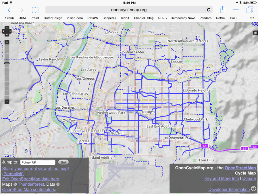
View OpenCycleMap on line and find an area that you are familiar with. Zoom in to see the different bike routes in your area. Red lines are national bike routes, violet lines regional bike routes, and blue lines the local bike routes. In Albuquerque they are mostly blue because it is a local bike route system.
In Albuquerque our local bike route network will be mostly blue lines and as you zoom in closer you will see those blue lines come in a few different types.
- Blue highlighted streets are bike routes, generally chosen because they are quieter streets.
- Blue highlighted streets with darker dashed lines on the sides are streets with painted bike lanes on the side of the street.
- Single blue dashed lines are physically-separated bike paths usually not on the street at all, but rather follow arroyos, cross within parks, or as “multi-use paths” alongside and protected from streets.
Different people have different levels of comfort cycling in traffic. So when planning your route, pick a route based on your level of comfort. If you don’t like being on the street with cars going by you at 35 or 40 mph (and I don’t blame you) don’t pick those routes. There is usually another way to get where you want to go on quieter streets nearby, even though those alternatives might not be designated bike routes. This requires looking at the map closely and some additional planning on your part.
Taking your digital map with you
How do you take digital maps like OpenCycleMap with you on your tour and follow your route in real-time as you ride? First you need a digital device that has GPS capabilities like a smart phone. Then you need a navigation app for your mobile device that uses OpenCycleMap as the base map.
Ride with GPS is one good option. They offer free, excellent, online mapping software that you can use with your computer or tablet to create custom routes. Their free app (for both Apple and Android platforms) allows you to follow your route while riding. The app allows you to access routes you have created on the on-line software on your computer. Ride with GPS is all you need for shorter, less complicated bike tours. You’ll need to set-up a user name and password to get your free account going but with all their video tutorials it will be well worth it.
On the Bike
But now you need a way to carry your mobile device on your bike so you can follow your routes! You can put it in your pocket (not ideal) or mount it on your handlebars (much better!) so you can see it and keep your hand on your handlebars where they belong.
Don’t be a distracted cyclist! As with any digital device, do not use while operating a moving bicycle. Stop in the shade somewhere if you need to take a closer look at the screen.

One of the concerns with digital devices is battery life. This can be solved with a battery pack that you charge overnight and plug into your device on the road for extended travel.
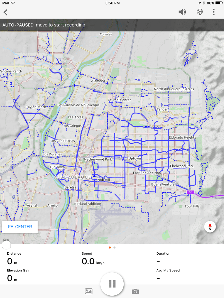
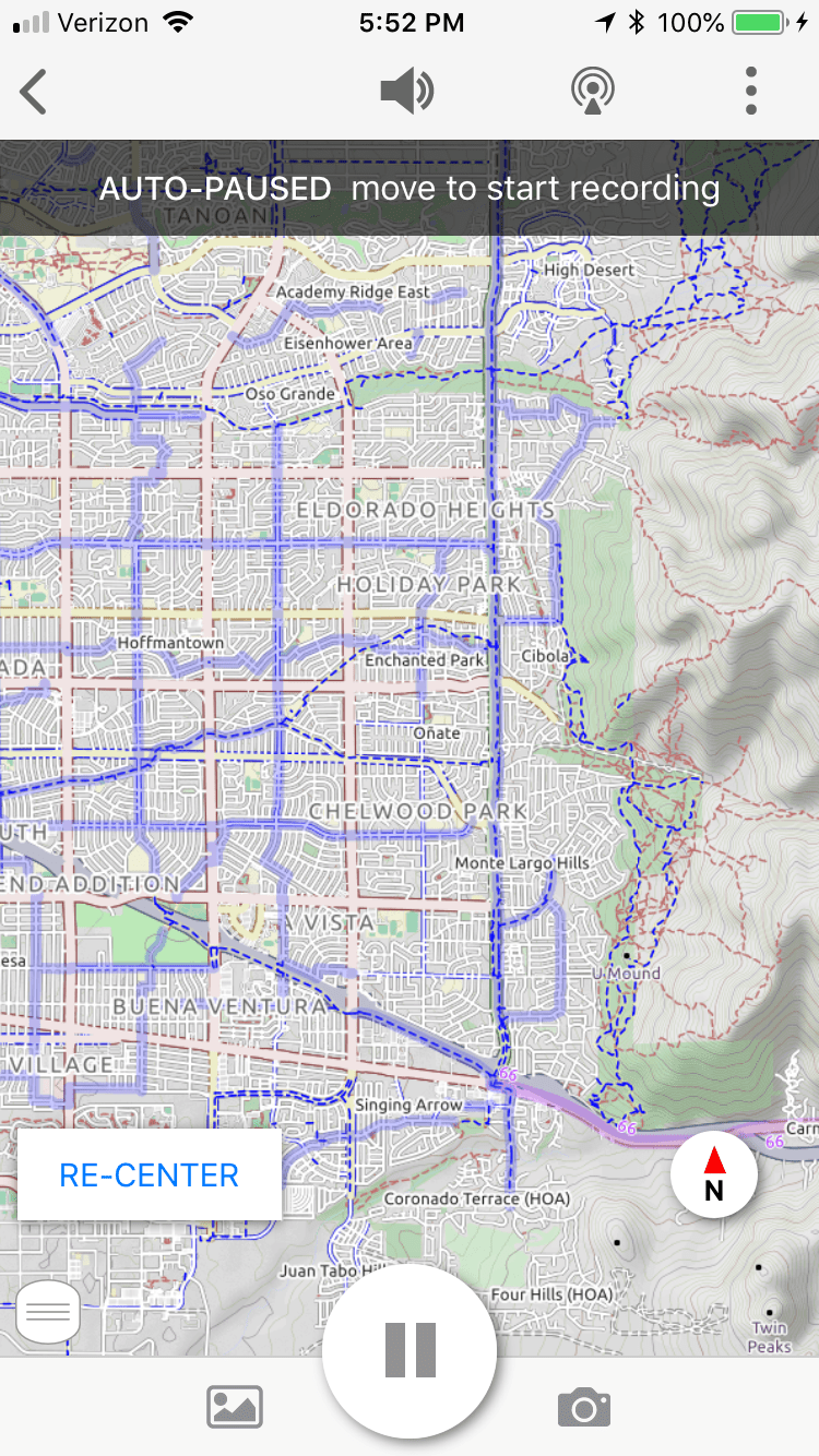
Now that you’ve downloaded the Ride with GPS app and mounted your device on your bike, it’s time to practice with this new technology. Start with a ride in your own neighborhood on bike routes you know appear on OpenCycleMap. When your Ride with GPS navigation app is turned on, and the base map set to OpenCycleMap, hit “go ride” in the upper right corner of the screen. Doing so finds your location and puts you right in the center of your map.
Then, as you ride the map will move under your position. Zoom in to find the right scale so you can easily see when you’re on a bicycle route … and when you aren’t! This is how you “stay found” while bike touring. Another feature: you can record your ride, if you want to.
Creating your own custom tracks
For longer rides into parts of town you don’t know as well, I recommend that you take a few minutes before leaving home to plan your ride with Ride with GPS on the computer and creating a custom track of your route. On a paper map, you might use a yellow highlighter to draw out all the different turns you want to make. In the digital world, “tracks” are your highlighter. The custom track you create will then be available on your Ride with GPS app map on your phone, enabling you to see all of your turns along with the icon indicating where you are on the map. You can even set Ride with GPS to verbally tell you when a turn is coming up, and if you’ve missed it.
OpenCycleMap shows all the small back streets and low traffic options to connect bike trails or to get to specific locations. By taking a few minutes to create your own custom track at home you before you ride, you will be able to plan a safe route. You will also know how long the route is and how much elevation gain to expect. This way you can be sure to make it home by nightfall or to your meeting on time.
Remember that just because a road is marked as a designated bike route, you don’t have to use it if there is too much traffic for you. There are many side streets that are not official bike routes which may be perfectly suitable.

Follow the directions on Ride with GPS to learn the basics of making your own tracks.
Other Tips and tricks
- Safe bike routes may not be as direct as the routes you drive.
- Switch to “satellite view” to see areas in question when mapping.
- Jot down locations of areas to check out when you’re driving if you’re not sure about biking there.
- I don’t recommend riding on bike lanes along roads with speeds over 35 mph for safety reasons.
- Dress in high viz or bright colored clothing and use blinky lights so drivers can more easily see you.
- Obey the rules of the road and be courteous to drivers so that you are a good ambassador of the sport.
- It you find yourself in a bad spot with too much traffic and no place for bikes, don’t just tough it out, become a pedestrian for a bit and use the sidewalk to get out of there.
- When crossing streets and intersections make sure you have enough time to cross before you start to cross. Don’t blindly trust that drivers see you or will slow down for you.
If you have any other helpful tips or tricks please leave them in the comments below. We can all learn from each other. Take your time, explore the city, have lots of fun, and, most important be safe out there!
