
“LHF” in our blogpost “headline” combines two horrid, horrid tendencies: trite expressions & making everything an acronym. Yes, “LHF” stands for “low-hanging fruit.” How many times have you been at a public meeting or dive bar, BSTWP (Brainstorming Solutions to World Problems), at which somebody will take a global problem, let’s hypothetically call it “bikeways network connectivity” and announce the presence of some “low-hanging fruit,” a solution that does little to perhaps nothing to solve the global problem, but is easy, cheap, and especially easy.
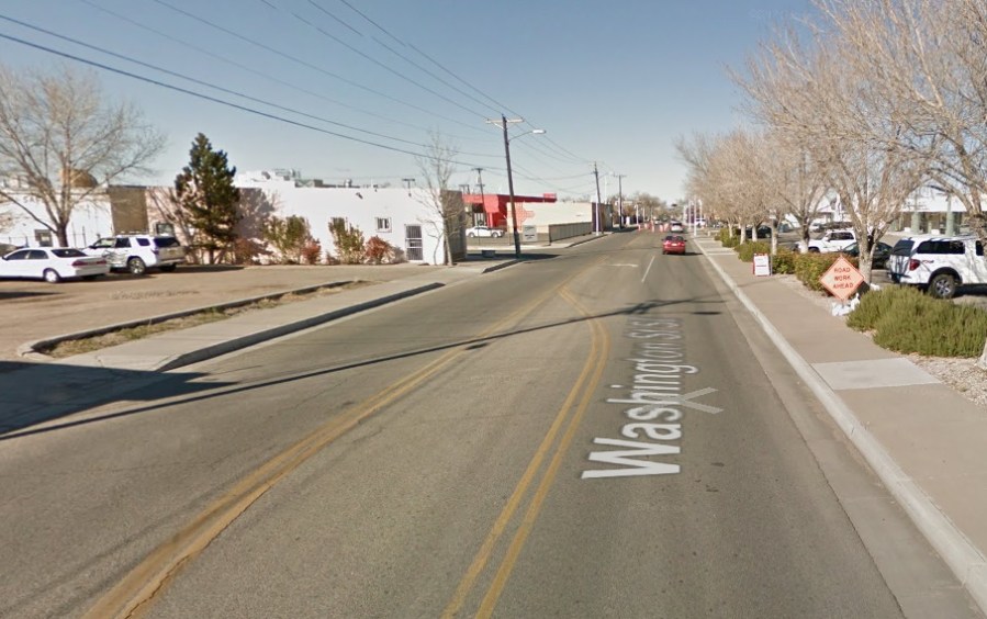
Well sit down at the dive bar that is Better Burque, and let’s leisurely, thoroughly pick some fruit. Namely, let’s finish that little stretch of Washington SE between Central Ave. and Zuni/Lead/Coal that currently doesn’t have bike lanes:

This is the very definition of LHF; in fact, Washington between Central and Zuni might be called “watermelon,” for it’s basically lying on the ground, ready for picking. It’s 1306.65 feet (trust me, I measured on Google Maps) of 35 foot-wide roadway (again, trust is important, people!) that everybody agrees needs to be converted from bike route to bike lanes.
And, by “everybody,” we, of course, mean everybody we talk to/hear from at public meetings and dive bars. You know…everybody.
The big reason why this little stretch is so important to bike network connectivity is Zuni SE. Only a few years ago, the idea of cyclists safely riding Zuni west from Washington SE was inconceivable. NOBODY in their right mind would ride Zuni! Then came what might be the single most important roadway reconstruction project in Burque’s last 25 years (no, it’s not the Big-I reconstruction or Paseo “flyover): the Zuni Road Diet.
Illustrating just how unthinkable riding Zuni was up to the Diet in 2016, let’s again look at the current bike map:

Still, two years later, Zuni still has no north/south crossing bike facilities all the way from Alvarado SE to Utah SE. That 1.52 miles (trust me). Before Zuni Road Diet (ZRD), you were supposed to either: 1. Ride parallel Bell SE; or, 2. Not ride across the International District at all, what are you crazy?
ZRD changed many things, none more so than cycling, but the bike map has yet to catch up to the new reality (BTW, your humble blogposter apologizes for all the acronyms, but they used to be in K-12 education. That profession simply hard-wires it into one’s DNA, which is, of course, another acronym).
Today’s LHF is really just one of many north-south changes that need to happen along Zuni. Perhaps most important of all would be extending the bike lanes on San Pedro from Bell SE to Lomas NE, fixing that currently disconnected bikeway. But that “fruit” is metaphorically way up there toward the top of the tree. Short answer is “we’re working on it” (WWOI).
So let’s finish our thought on the watermelon that is Washington SE instead.
We mentioned that Washington between Central and Zuni is roughly 35 feet across. Given the current thinking that driving lanes need only be 10.5 feet wide, and given this stretch has single driving lanes in both directions, we have OODLES of space to put bike lanes, right!?! Not just bike lanes, but buffered! Something like 2 x 10.5 = 21 feet of driving lane, 2 feet of buffer (4 total) and 5 feet of bike lane (10 total) = 35. Yeah, but…
Yup, it’s plenty wide along this stretch and that width is filled in with a bunch of median and designated left-turn lanes. Including left-turns enabling drivers to go into parking spaces in front of the aged strip malls and stray businesses along this stretch, as well as little off-set streets like Mesa Grande/Silver.
So the upshot is that Washington SE is “watermelon,” but we’re gonna have to tap on the melon a bit, so to speak, before picking this LHF. Namely, we’ve gotta get the idea across that these businesses will see zero negative impact from turning continuous opportunities for left-turns into left-turns that stop the traffic behind the turning driver. And, we have to point out that significant queuing will not occur behind this driver as s/he waits to turn left.
Why do we have to point all this out? Do you really have to ask that question? Does BB really need to point out the straw that stirs the roadway engineering drink in this town/country? I didn’t think so. And you thought this was LHF…
To answer the above, MRCOG traffic counts for this stretch of Washington SE are right around 6,000 Average Weekday Traffic (AWDT). What, you don’t believe me? Trust is so important, people. I am hurt by your lack of trust.

Thus, the concluding question is “Can we reasonably get rid of continuous/contiguous left-turn lanes with daily traffic counts of 6,000?” Astute readers will note the most important, and persnickety, word in our question is “reasonably.” What constitutes “reasonable” includes a veritable Long Island Ice Tea of politics, opinion, and changing attitudes over time. One can easily get a hangover just contemplating “reasonably.”
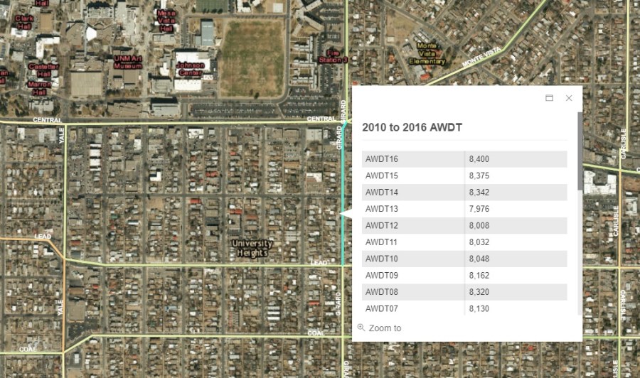
Nevertheless, let’s plunge forth and try to answer our question. Most helpful in this regard might be to look at nearby north/south streets, looking for precedent. Unfortunately, it’s a mixed bag. Yale between Central Ave.and Coal SE has such a lane, as does Carlisle. On the other hand, Girard SE does not, even before its “Complete Streets” makeover of 2016/2017. Girard also has historically higher traffic counts than Washington SE (~8,000 v. ~6,000):
Armed with all this info, those hungry for watermelon might be ready to finally pick our LHF and either formally petition Washington SE lose the turn-lanes and add buffered bike lanes, or simply undertake 1,306.65 feet of tactical urbanism and achieve the needed transformation with a few toilet plungers and chalk. Why did this very LHF turn out to be so hard?
The answer to that question, as it is for almost all supposedly low-hanging fruit, is that such things are never easy. For instance, we haven’t answered those who notice Washington has far more businesses along this stretch than Girard, or those who recall that Washington between Central Ave. and Copper NE has both turn-lanes and horribly skinny bike lanes. “Why can’t we just do that?” some might ask, seeking not just watermelon but LHF compromise so low it’s underground. Potatoes, we might call it such a compromise.
No, we’re not after vegetables here. We’re sticking with actual fruit.
Washington SE between Central and Zuni SE must lose its left-turn lanes, to be replaced by Complete Streets, Development Process Manual-compliant bike lanes (CSDPMSBL). Not to mention flexposts and other accoutrement at the Central and Zuni/Lead/Coal intersections. Oh, and that Suddenly Ending Bike Lane (SEBL) on Coal just west of Washington needs to be corrected, and we need to make the left-turn from southbound Washington to westbound Zuni safer, too.
Eating fruit, even watermelon, is harder than you think.
