
If you, like me, live “down here” in the far South Valley, you know all about the in-progress three-week closure of eastbound Rio Bravo Blvd. at Isleta Blvd. as work is done on supports for its Rio Grande River Bridge.
From what I hear, the situation crossing the River at Bridge/Cesar Chavez up north is gridlock during Rush Hour due to this closure, and much strategizing goes into what we call “driving into Town.” Many also bicycle or walk across the River on Rio Bravo on a bike/ped bridge you’ll see below, including a steady stream of folks who walk to/from Joy Junction on 2nd Street east of the River to the grocery store and other amenities west of it.
I am one of the many cyclists who use this bridge several times a week, as it connects me to the Bosque Path so I don’t have to ride: A: Isleta Blvd. and its three-foot bike lanes into town; B. on Rio Bravo itself. Both of these far less desirable, far more dangerous options are obviated by this bike/ped bridge.
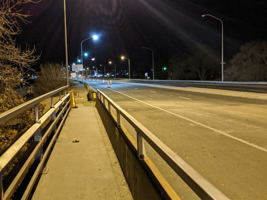
So it was with some consternation that I came across this view yesterday and yesterday evening:

Road closures are always an interesting area of wildly varying value to cyclists and walkers. Having a busy dangerous road closed can either be: A. The greatest thing ever, e.g., one can now cycle in car-free wonderfulness on the closed eastbound stretch of Rio Bravo, or, B. The worst thing ever because it is deemed, through some mysterious bureaucratic process, that the road should also be closed to cyclists/walkers.
Roadway construction decisions regarding non-motorized travelers are almost always an afterthought by construction planners, managers and workers, and on the first day of the closure there wasn’t an orangesicle blocking the bike/ped bridge’s west end. Yesterday, there was. It is also almost always true that not much thought, afterthought or otherwise, goes into decisions on whether to allow walkers and cyclists to use roadways under construction.
I mean, they’re cyclists and walkers. Who cares about them?
At the same time, it’s a pretty defensible position to close roads/bridges to walkers and cyclists, if one has the mindset that Closure = Safety. But there is nothing safer than a walkable/ridable road with ZERO drivers on it (see Rio Bravo eastbound above). It is a veritable Shangri-La. It is a “consummation devoutly to be wished.” It is way fucking cool.
One complication here is that the bike/ped bridge is on the south/eastbound side of the overall bridge. It is very likely that if the bridge were on the north/westbound traffic side it would not be “closed,” as the westbound lanes are open. It is also true, however, that the bike/ped bridge is truly a east AND westbound bridge, as few in their right mind would choose to walk/ride the shoulder of Rio Bravo instead of having the physical protection the bike/ped bridge provides.
Hence, deciding whether to close the bike/ped bridge is interesting, but closure ultimately results in a far more dangerous journey for those walking and cycling. So, this:

Became this:
One aspect of such lo-fi Tactical Urbanism is that one could just talk to the “right person” and convince them to move/remove the sign. Of course, there are several huge impediments to this “talking cure”:
- Who is the “right person,” in this case at NMDOT?
- How does one successfully contact this person and get a response while one is actually at the site in question?
- If one chooses to ask those actually on-site, the answer is very often going to be “no” because: A. They didn’t make the decision, and B. Closure = Safety, right?
- In this case, it’s night, so there’s nobody there to ask.
In a truly perfect world, NMDOT would have something along the lines of an “Active Transportation Coordinator” who would consult on all roadway construction jobs and make sure that safe, legal detours and signs were in place for non-motorized roadway users. This person would look at things from the currently afterthought perspective of those walking and cycling, and hold the managerial heft to be able to make decisions AND ensure those decisions are followed in toto.
Until that truly perfect world comes around, I just moved the orangesicle.
I have another ride into town this afternoon. I’ll let you know if the sign is moved back to the middle of the bridge path. If I see anyone in a hard-hat and safety vest nearby, I might ask them about it. But probably not.
Stay safe out there, everybody!

Subscribe
LikeLike