New Mexico Department of Transportation held a virtual public meeting earlier this week to kick off the eventual scheduled 2023 replacement of the current Rio Bravo (NM-500) bridge across the Rio Grande. So this seems as good a time as any to tell you how I, a frequent cyclist who lives west of the River and south of Rio Bravo Blvd., cycles home from town via the Bosque Path.
When I first moved way down to the Deep South Valley (DSV) back in 2000, I rode home by just taking Rio Bravo westbound across the bridge, then snuggling in (somehow) to the double left-turn lane at Isleta, and left southbound on Isleta.
Then around 2003 I had “an incident” at that double left-turn lane, one that resulted in my lying on the pavement with my head uncomfortably close to a tire on an 18-wheeler.
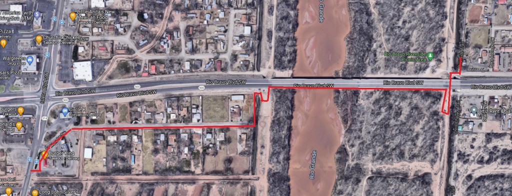
Thus ended my riding to/from town for a year or so, until an acquaintance hipped me to the route you see above. Let’s take it step-by-step:
- Ride south on the Bosque Path (aka: Riverside Trail) to Rio Bravo;
- Go under Rio Bravo;
- Head into a dirt parking lot often slightly to completely filled with vehicles of those fishing in the adjacent Albuquerque Drain, hiking the high levee, and/or taking part in conversations/transactions one wishes to ride away from as quietly and quickly as possible;
- Shimmy up a little steep hill and around to the utterly non-ADA eastern entrance to the current Rio Bravo bridge “pedestrian access,” a barely four foot wide stretch of concrete separating from the speeding melee by concrete and a rail;
- Exit the western similarly non-ADA entrance to said “pedestrian access”;
- Bounce down a short stretch of dirt along the River’s west side levee;
- Walk the bike around the adjacent ditch, and down its western bank;
- Get the bike under a Conservancy gate at the eastern end of La Mora SW;
- Ride down quiet, pleasant La Mora SW;
- Turn left through the Burger King parking lot (the angle to enter Isleta is much better from its driveway); and,
- Turn left onto Isleta Blvd.
I’ve been doing this now for over 15 years, averaging about 100 rides to/from town annually on the Bosque Path. That’s roughly 1,500 convoluted excursions.
That’s how dangerous it is to ride Rio Bravo Blvd at the River in its current configuration. In fact, it’s gotten much more dangerous over the years, as traffic numbers have dramatically increased with new housing/schools/Walmart further west at Las Estancias and points west.
It is true that a number of cyclists, particularly your hard-core lycra-festooned road warriors (e.g., “MAMILs“), ride Rio Bravo in its current configuration. God bless ’em. Still, for a huge number of current and potential cyclists (not to mention walkers and those rolling on wheelchairs), Rio Bravo at the Rio Grande is a veritable brick wall or Bridge of Death.
None shall pass (unless one is willing to undertake the 11-step excursion outlined above).
If you happen to be a South Valley person interested in making it far more sane to ride/walk/roll across this bridge, or are merely one who generally favors such sanity, perhaps you’ll take a few minutes to visit a fairly thorough, yet quick and easy to complete, survey from NMDOT on the project. As I understand it, a recording of this week’s public meeting is also scheduled to be available on the project website in the next few days.
Full disclosure, I haven’t been riding the Bosque Path as much these days due to the pandemic. But some day…some day, this pandemic will be over and it would sure be nice to ride home from the Path without the 11-step excursion and without having one’s head dangerously close to the tire of an 18-wheeler.
Have a great weekend, everybody.
