

They and Rod Stewart say every picture tells….you know the rest.
And the screengrab above very much tells a story, one with many twists, turns, and what-have-you’s (to quote the immortal bard) in terms of many things, including current and future non-motorized transportation in the SW Mesa.
But like The Dude, I’m struggling to tie all the loose ends of this story together into some form of digestible narrative. And nothing says “indigestible narrative” like a blog post. So here goes…
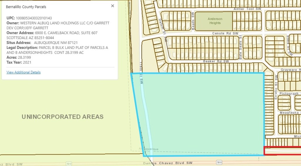
The above is a screengrab from the City’s “Advanced Map Viewer,” CABQ’s vaguely Orwellian name for its online GIS of area zoning and property ownership (among other things). You can use it to find out who owns your property, and, perhaps more interestingly, who owns any parcel in town/county.
As you can see from the above, the owner of this parcel in blue is “Western Albuq Land Holdings LLC…” If you’ve followed area news fairly closely over the past many years, that name might/probably/definitely rings a bell.
And that loud ringing sound in your head is: Santolina.
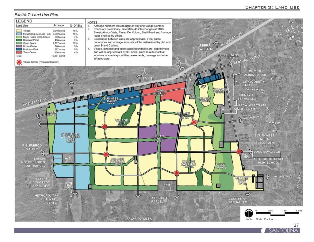
And to help make a long indigestible narrative shorter, the parcel above is at the far eastern edge of the proposed Santolina; in fact, it’s not precisely included in the Santolina Master Plan map:
NE corner of 118th St. S.W. and NM-500, Dennis Chavez Blvd.
So Santolina owns this parcel that’s technically not in Santolina. So what?
Well, let’s take another look at the “story” screengrab, adding a highlight:
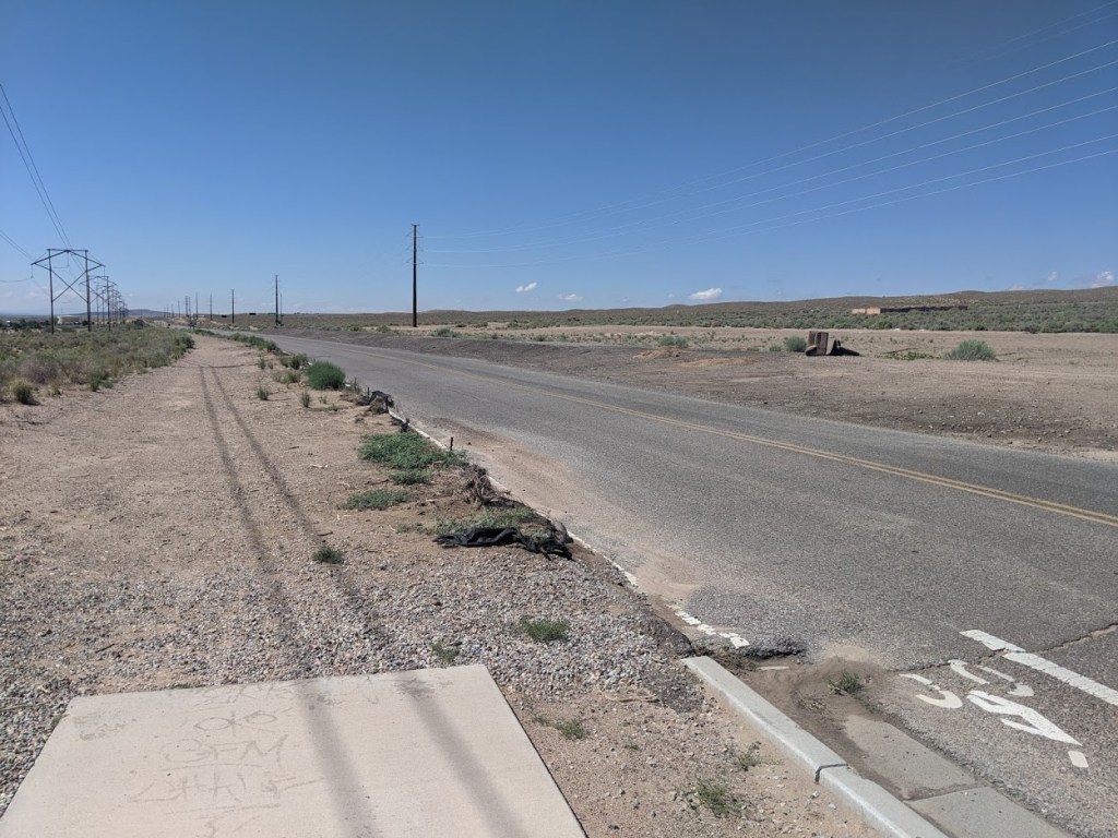
In the above, that little curvy white line segment in that little red rectangle is a multi-use path, one that runs between the housing development north and east of Santolina’s parcel for about 1.5 miles, all the way to just west of Coors Blvd. It’s a really nice multi-use path running along what is a very un-nice (from the non-motorized traveler perspective) stretch of highway.
And currently the very nice multi-user path suddenly ends at the eastern edge of the parcel in question and does NOT extend to 118th St.. Instead, it currently looks like this:

It’s worth noting that the popularity of this paved path is such that many users continue on its unpaved portion, but that number is not 100% of overall users, obviously. Example, anybody rolling via wheelchair. Think how much more non-motorized traffic this path would get if it was paved all the way to 118th St., instead of suddenly ending in the middle of nowhere.
So why does it end in the middle of nowhere? And why does the sidewalk also suddenly end on the east side of 118th St?
Answer: Santolina
If you’ve been following the news the last few years, you know that Santolina has been pilloried for everything from water usage to dandruff (okay, I made this latter one up, but do we absolutely know that Santolina does not cause dandruff?) And it’s perhaps unfair to singularly blame Santolina for the non-existent non-motorized infrastructure through this Santolina-owned parcel. How many million other undeveloped parcels exist in this town/county with zero non-motorized travel infrastructure? Nobody can count that high, but that’s not true, because such a count is actually required as part of any American with Disabilities Act (ADA) transition plan, including the CABQ one that has been in draft form, never finalized, for years and years.
But that’s another story.
Getting back to this particular story/parcel, there’s one more wrinkle that makes this story harder to write and seemingly impossible to construct into anything approaching an “elevator speech.” Hence, it’s in a blog post.
There’s this thing called the “Long Range Bicycle System” (LRBS) map. It’s put together via an intergovernmental decision-making process, with public input, and illustrated/curated by the Mid-Region Council of Governments (MRCOG). The map identifies where all existing bike/multi-use paths, lanes, boulevards, etc. are AND where bike infrastructure will should be included in the future. Right now, the general idea is that the LRBS includes such proposed infrastructure out to the year 2040.
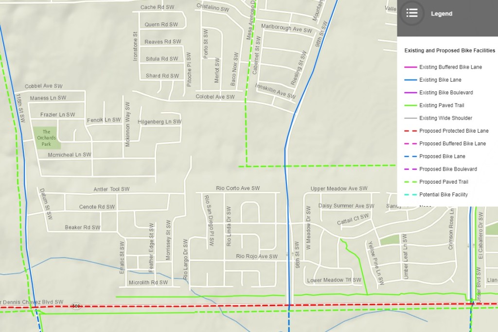
Looking at the LRBS excerpt above, what do you notice about “our” parcel at the NE corner of 118th St. and Dennis Chavez? Hmmm…the little green line segment correctly ends now at the eastern edge of the parcel BUT THERE’S NO DASHED GREEN LINE EXTENDED TO 118TH STREET! Thus, the “plan” is to never extend the “existing paved trail” from its current end in the middle of nowhere to 118th St.
Not by 2040. Not ever, really. Unless…
Santolina develops the parcel.
And that almost certainly won’t happen until Santolina develops ALL the parcels that make up the much-reviled Santolina Master Plan.
In other words, non-motorized travel at the edges of this parcel will always suck until we get stuck with Santolina. Some “Sophie’s Choice” there, huh?
From a story perspective, this “Sophie’s Choice” is nowhere near as compelling as Styron’s novel or Meryl Streep and Kevin Kline’s performances in the film. Granted. But there’s a story here somewhere.
If only I could figure out how to tell it.

wow, thank goodness for the internet, and sleuths like you Scott!
LikeLiked by 1 person