It’s been a while since we updated on our effort to measure the width of all the bike lanes in Albuquerque. Reasons for this are many, including slothfulness on the part of your current chronicler. The hot Summer weather also played a role, most prominently in my often using it as an excuse to be slothful.
That said, putting a tape measure on Gibson Blvd. in 95 degree heat while cars redefining the word “zoom” past is not nearly as much fun as it was yesterday riding in the Fall coolness through much of the SW part of Albuquerque. I’d neglected to “knock out” this part of town principally because:
- I don’t have many personal business/shopping/entertainment/errand reasons to be at the corner of 86th St. and Bridge, for example.
- I was kinda dreading it, really, as my mind just turns it all into one giant strip mall, awful subdivision hell.
The weather helped make yesterday’s measuring effort fun, but I also can report the ride wasn’t nearly as death-defying and visually horrific as I feared (with a few exceptions). Moreover, many of the bike lanes in the quadrant south of I-40 and west of Isleta are of high quality. As is true everywhere, this is not always the case, but much of these newer parts of town have solid bike infrastructure. I’ll save specifics on the bike lane highs and lows in SW ABQ for future posts, but can’t wait to show you our leading candidate for “Burque’s Widest Bike Lane/Buffer Contest.” Gaze upon ye works below in wonder, folks:
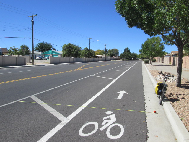
That is a full 15 feet o’ bike lane and buffer, ladies and gentleman! This is De Vargas SW and Timarron Dr. heading westbound up the hill/Mesa. While there is a small section of the new Zuni restriping near Highland HS with a bike lane/buffer combo of approximately 5 million feet in width (I haven’t measured it yet), that’s a much shorter stretch than the one on De Vargas. One wanted to run over to Home Depot, buy a bunch of plant boxes, come back and plop those babies on the inside of the buffer, put up some “De Vargas Bikeway” signs and contact the League of American Bicyclists pronto for that “Platinum” designation.
It’s that kind of bike lane.
While De Vargas SW is extreme, pleasant biking and five foot or better bike lanes were found in many places yesterday. Also, at least one danger spot, Bridge Boulevard, is due for a major reconstruction that will improve what is now a bumpy, debris-filled ride on less than 3-foot bike lanes with cars going at least 40 mph only inches away. I wish the same could be said for Central at 86th, but the A.R.T. Project isn’t going that far West. I know this section of Central gets bike riders, but a three-foot bike lane in a 55 mph zone just ain’t a bike lane, or much of a place to ride a bike at all. More about that to come in a snarkier post.
But this is not that snarky post. Instead, let’s focus on the 36 data points knocked out yesterday, making our AABLE total now 260. Is that a faint, very faint, light I see at the end of the bike lane width measuring tunnel? We’re really getting somewhere now, and, with your help, we can get there faster. Below is a copy/paste from Excel identifying the streets/sections we still need to measure.
Looking over the list, the North Valley between river and I-25 is in real need of measuring, although there are still spots left open all over town (including the SW quadrant, as I didn’t make it north of Central yesterday). Drop BB a line if you’d like to see all 260 data points so far, or if you have some data to share.
Thanks and happy riding/measuring!
| 2nd St. (North Valley) | |||
| 72nd NW near Susie Reyes Marmon Elem. | |||
| Alameda (Both sides of I-25) | |||
| Atrisco (I-40 to Central) | |||
| Atrisco Vista (see Volcano Vista) | |||
| Barstow (Harper to Paseo del Norte Far NE) | |||
| Bluewater NW | |||
| Broadway (Downtown and around I-40) | |||
| Candelaria (west of I-25) | |||
| Carlisle (south of Coal) | |||
| Central (west of downtown) | |||
| Chelwood Park (north of I-40) | |||
| Cherry Hills (Barstow to Cherry Blossom Far NE) | |||
| Coors (North Valley) | |||
| Copper (near UNM) | |||
| Copper (North of I-40) | |||
| Dorado/Wenonah (FAR East west of Tramway in Four Hills) | |||
| Eubank (Paseo) | |||
| Fortuna (West Mesa HS) | |||
| Griegos | |||
| Harper (Almost I-25 to Burlinson NE) | |||
| High Desert (all) | |||
| Indian School (East of I-25) | |||
| Jefferson (west of I-25 roughly Osuna to past San Antonio) | |||
| Kirtland AFB (all) | |||
| Layton (Academy to Eubank) | |||
| Los Volcanoes NW | |||
| Matthew (near Rio Grande North Valley) | |||
| MLK (once restriping is completely done) | |||
| Montano | |||
| Monte Vista | |||
| Osuna (post-restriping and further NE) | |||
| Rainbow (Volcano Vista H.S.) | |||
| Rio Grande (Griegos to Mountain) | |||
| Rosewood (Harper to Cherry Hills Far NE) | |||
| Roy/Tramway (at Sandia Casino) | |||
| San Francisco (Ventura to Holbrook far NE) | |||
| San Pedro (S of Zuni) | |||
| Tiburon NE (south of Paseo) | |||
| Unser | |||
| Volcano Vista (shows as bike lane on CABQ Map, but is in fact just shoulder) | |||
| Western Skies (off Singing Arrow between JT and Tramway FAR East) | |||

Dibs on Roy, Indian sch, Monte vista and Rio grande.
LikeLike
Biliruben: Just to clarify, Rio Grande Blvd. has been measured from Paseo to Griegos. We still need measurements south of Griegos. Btw, my plans are to knock out quite a bit of the North Valley tomorrow (up to Alameda). I could get the southern part of Rio Grande, as it’s a bit out of the way from your other “dibs,” and that would leave you Roy, Indian School and Monte Vista.
– Scot
LikeLike
They’re all yours, Bilruben! Just FYI, we’ve already done Indian School west of I-25 (and that little stub of Mountain west of the highway as well). Thanks!
LikeLike
Sounds good. I’ll do my best to get to them this weekend.
LikeLike
I’ll sub-in Copper/Campus Parkway for Rio Grande.
OT: Are there any regulations against garbage cans and parked cars in bike lanes? Clearly if there are, they aren’t enforced, but just curious how bristly I should allow my “Hackles of Righteousness(TM)” to become.
LikeLike
Biliruben: Copper/Campus works great as replacement. Regarding your OT point, which isn’t OT, it was trash day in the North Valley, Rio Grande Blvd. included. I have some unlovely photos of garbage containers (and parked cars) swallowing up bike lanes (Matthew…as always, Candelaria, Rio Grande, etc.). It’s a big problem; concerning cars, there’s been talking of firming up regulations, but enforcement is another matter.
LikeLike