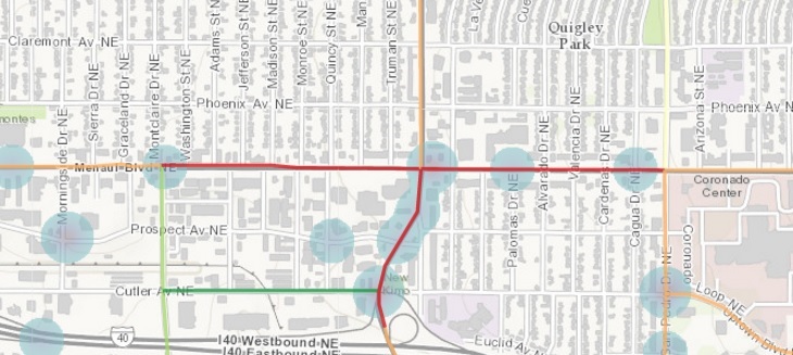
PCI color-coding for area around Menaul/Alvarado (subject of future post) via ArcGIS platform mentioned below
We might not have much in New Mexico when it comes to some things (e.g., manufacturing jobs, Malaysian restaurants, ethical House leadership in the Legislature), but one thing we do have, I’ve found, is a number of local government folks patiently ready to help us better understand the sort of issues we tend toward here at Better Burque.
While we’d love to write essay after essay about Malaysian restaurants, we tend toward issues surrounding transportation more here, particularly those transporting themselves via bicycles and as pedestrians. In researching/writing more specifically on these issues the past nine months, BB has been helped a great deal by several staffers at City of Albuquerque, Bernalillo County, “MRCOG” and even the New Mexico Department of Transportation.
When yours truly has had a question about some arcane aspect of getting around Albuquerque and environs, these staff folks have responded and their input has helped shape the “facts” behind the rantings and ramblings here. BB thanks all who have helped and continue to do so.
Here’s an example: In researching/writing a series of stories this year regarding the pedestrian injury/death epidemic, much information has come my way via these folks. This includes pointing me to the Pedestrian Composite Index (PCI), a statistical look at area roads and their level of pedestrian “deterrence” and “generation” when it comes to walking these streets. While PCI is online, I must admit I didn’t find/look at it until directed by these staffers.
They’ve also been kind enough to explain the methodology involved in calculating, for instance, that the stretch of Lomas between San Mateo and San Pedro (a stretch which includes the site of the recently discussed HAWK signal) is 124.59, while Isleta between Blake and McEwen (where one finds the HAWK at Isleta/McEwen is 77.27. Generally, the higher the number, the greater the need for high-quality pedestrian infrastructure. FYI, the single highest PCI in town is Central between Louisiana and Pennsylvania at 199.99. Unsurprisingly, stretches of Central take six of the nine highest PCIs in town.
All specific numbers listed above are from the aforementioned kind staffers. I don’t want to inundate them with requests, but anyone interested in delving a bit more deeply in these issues (and, seriously, if you weren’t, why would you be here?) is encouraged to seek out information. Starting online at places like MRCOG, the City, or County can get you to helpful folks much easier than it might seem.
I know, I know, you’re quizzically stammering: “But Scot, helpful customer service from the government?” Understood. Still, this is not like calling the IRS office 800 number about your revised return. These folks are passionate about what they do and eager to “talk shop.” Admittedly, IRS customer support does not seem to share this level of passion, or humanity.
Personally, finding out about PCI really evolved from conversations about how to best visually present findings of our bike lane measuring effort “AABLE.” As an aside, I knocked out a pretty big chunk of the North Valley yesterday, and have to say NV generally has the weakest bike infrastructure in town. 2nd St., Jefferson, Griegos…shudder. More about that in another post. Getting back to the point of this essay, I’ve had several suggestions from readers, including City/County/MRCOG on how we can use the same ArcGIS platform used to visually depict PCI, bike/ped crashes, and traffic flow.
Better Burque is, of course, very much looking forward to seeing the bike lane info added on to the ArcGIS layers. Always looking for more help, as we’re getting closer to finishing the measuring effort now (we’re down to about 33 streets/segments, shown below), BB would love to hear more from readers/staffers on how we can get this done.
Based on the very helpful previous interactions mentioned above, not to mention the help from others in measuring the lanes, I’m 100% confident this next visual step will happen. Thanks in advance to those who help make that happen.
Have a great weekend, everybody! Now that list of remaining AABLE streets I promised:
| 72nd NW near Susie Reyes Marmon Elem. | ||
| Alameda (East of I-25) | ||
| Atrisco (I-40 to Central) | ||
| Atrisco Vista (see Volcano Vista) | ||
| Barstow (Harper to Paseo del Norte Far NE) | ||
| Bluewater NW | ||
| Broadway (Downtown and around I-40) | ||
| Carlisle (south of Coal) | ||
| Central (west of downtown) | ||
| Chelwood Park (north of I-40) | ||
| Cherry Hills (Barstow to Cherry Blossom Far NE) | ||
| Coors (North Valley) | ||
| Copper (near UNM) | ||
| Copper (North of I-40) | ||
| Dorado/Wenonah (FAR East west of Tramway in Four Hills) | ||
| Eubank (Paseo) | ||
| Fortuna (West Mesa HS) | ||
| Harper (Almost I-25 to Burlinson NE) | ||
| High Desert (all) | ||
| Indian School (East of I-25) | ||
| Kirtland AFB (all) | ||
| Layton (Academy to Eubank) | ||
| Los Volcanoes NW | ||
| MLK (once restriping is completely done) | ||
| Monte Vista | ||
| Osuna (post-restriping and further NE) | ||
| Rainbow (Volcano Vista H.S.) | ||
| Rosewood (Harper to Cherry Hills Far NE) | ||
| Roy/Tramway (at Sandia Casino) | ||
| San Francisco (Ventura to Holbrook far NE) | ||
| San Pedro (S of Zuni) | ||
| Unser | ||
| Volcano Vista (shows as bike lane on CABQ Map, but is in fact just shoulder) | ||
| Western Skies (off Singing Arrow between JT and Tramway FAR East) | ||

MRCOG rocks. No doubt.
I wish DOT would actually prioritize those little red lines for wider, better sidewalks and bike lanes. In my neighborhood right now, they are busy spray-painting all sorts of lines on green streets and ones so residential, almost everyone just walks in the street. The workers told me these are the first step repairing the sidewalks. This is nice, but should be a really low priority. Seriously dangerous 3-foot sidewalks on nearby Lomas, (PCI= 112) are ignored, even though hundreds of school kids are forced to use them daily.
Research into practice. How do we get them to do it?
LikeLike