The ongoing work being done at Carlisle and Silver to install a cycle track treatment connecting off-set portions of Silver as part of the new iteration of the Bike Boulevard is an interesting study. After taking a close look a few days back, BB had another chance to take some photos last Friday evening, 10.28.16, at 5:30 p.m. (timestamps seem pertinent in a process as it evolves), and here’s what was found:
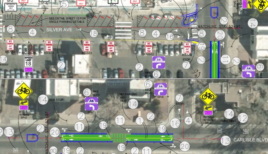
Illustration 1. Revisiting the Silver Bike Boulevard Plan (at 90%, in other words, not absolutely final)
Just to refresh memories and/or get readers up to speed, above is what was planned at “90%,” meaning tweaks were still possible to the implemented project, but this is the most up-to-date version available at the City of Albuquerque website. The plan calls for an 8 foot two-way cycle track in the median of Carlisle. Worth noting is that the original study from Parametrix, the engineering firm employed by the City to first study and then design the new iteration, called for a 10 foot cycle track. Why that’s worth noting will be discussed further down this overly long blogpost.
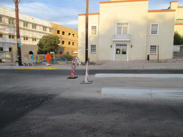
Photo 1. Northern entrance to cycle track.
It’s hard to capture the entire treatment in one photo (at least for a lousy photographer), so let’s start at this northern entrance. Unlike our last look at the work in progress, there is now a flashing warning “cone” dividing the cycle track and preventing motorists from mistakenly entering the cycle track. There is also a curious “no left turn” sign that we’ll talk more about after this next photo.

Photo 2. Looking north at northern entrance to cycle track.
And now we’re “in” the cycle track, looking more closely at the curious “no left turn” sign. The curiosity is: Who is being told they can’t turn left here? Motorists? Cyclists? Both? BB can report that, unsurprisingly, the sign did not stop motorists (or cyclists for that matter) from turning left. I caught a “cheating motorist” on camera doing so, but posting such a photo seems a bit unfair in such a confusing signage environment.

Photo 3. Looking south “up” the cycle track.
Looking up at the remainder of the cycle track, we note the flashing warning cones continue all the way to the southern terminus of the track, with dividing cones sprinkled along. We also see a human and canine pedestrian, using the curb gap in the cycle track to cross Carlisle. In the interest of privacy, we’ve sophomorically “airbrushed” the faces of both human and canine. In addition to privacy, this was done because we’re not interested in “busting” anybody here, we’re just noting that this is Carlisle and Silver near the Co-op. This is how people move in the area, and the cycle track treatment needs to keep this fact in mind.
In a positive sense, the end result of the track will be to serve as a pedestrian refuge, with the caveats that: A. cars will be turning into that gap (see below) and cyclists will be wanting to share the gap, too.
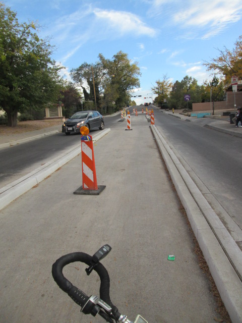
Photo 4. Motorist turning left/south from Nob Hill Shopping Center parking lot.
Of course, the reason there exists a curb gap mid-point in the cycle track is for folks to enter/exit this parking lot. The car here is not doing any illegal. You’re supposed to exit the parking lot by driving across a cycle track. BB will just let that sit with the reader for a moment or two.

Photo 5. The curb gap extended due to extenuating circumstances.
Now we get to perhaps the most interesting aspect of the treatment installation so far. You see the darker strip of asphalt in this photo? Look at the strip, and look at the condo driveway. Strip of asphalt; condo driveway. You see what happened? Yeah, person(s) in condo wanted to be able to turn left through the cycle track. Voila! This is not to criticize the condo residents; it’s just what happened.
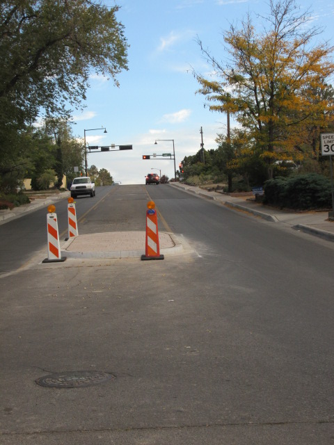
Photo 6. Raised curbed median just south of southern terminus of cycle track.
This median serves primarily to protect cyclists as they wait to turn left back onto Silver. There’s another such median at the northern terminus of the track. A couple of slightly interesting points about this median are: 1. This median wasn’t in the 90% plan; 2. There’s only three lighted orange cones here. BB has no idea what happened to the fourth one. Well, maybe a slight idea.
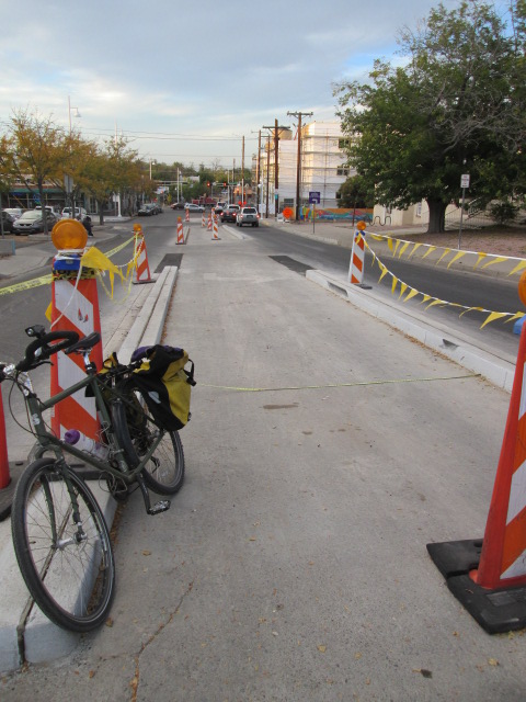
Photo 7. Measuring the cycle track.
One noticeable skill learned from measuring a ton of bike lanes around town is that you get pretty good at “eyeballing” the width of lanes. Having seen the 90% plans calling for an eight-foot cycle track, BB’s first impression was that the reality was wider than eight feet. In our measuring photographed above, we got 115 inches, or almost ten feet. You’ll recall that was the original width proposed by Parametrix in their study. Just a factoid, really, but if you recall our earlier concern that motorists would confuse the cycle track-to-be as just a turn lane, ten feet certainly makes such confusion more likely than eight.
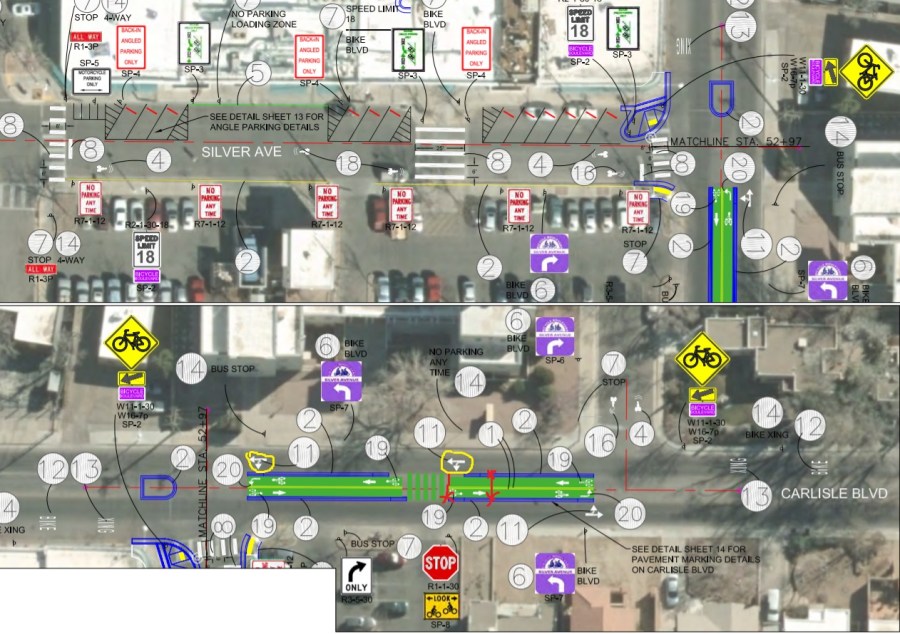
Illustration 2. Noted tweaks/points of the plan to this point.
Returning to those 90% plans, the above crudely notes the extension of the curb gap for the condo in red, and has yellow circles around the proposed left-turn option at both the Shopping Center parking lot and Silver. The result of both these new and originally intended aspects is that this is a HIGHLY problematic cycle track. To the point that we should perhaps reconsider other options.
There are just too many places to get hit here, and educating cyclists, pedestrians and motorists into how to use this treatment in a way that folks don’t get hit seems far too difficult.
As mentioned previously, yours truly preferred an earlier proposed option that had cyclists/pedestrians simply “escape” Carlisle by crossing straight across the southern Carlisle/Silver intersection, then riding/walking up the hill on an widened sidewalk turned into a cycle track (with pedestrian lane) on the east side of Carlisle to its northern intersection with Silver.
The “dealbreaker” for the median cycle track option occurred when it was decided motorists could still use the Shopping Center access along Carlisle. The new addition of curb space to the condo residents is merely illustration of how a slippery slope in safety reduction snowballs.
As with any treatment in this troublesome set of intersections, the “simple” crossing of Carlisle idea has dangers, but at FAR fewer points and with the option of a solution including some sort of flasher/HAWK bike/ped signal to stop traffic in order to make that crossing safer. Yes, such a solution would be an additional expense, but one wonders how much is being spent on the less safe alternative being implemented.
Another question raised by the treatment installation here is that of technical expertise. This is Burque’s first cycle track, and it’s being installed in a very complicated intersection. What level and depth of technical advice occurs between engineering firm, Parametrix in this case, and actual installers, the City’s Department of Municipal Development? More specifically, what instructions are given on detour signage, etc. while the treatment is being installed?
A few up-close looks at the installation process so far has resulted in a cringe-worthy level of observable near misses, “cheating” and lack of information. All users are pretty much “playing it by ear” at this point (it was even worse about a week ago), and the thought of such winging it involving two-ton automobiles going down steep hills at 30 mph is a bit disconcerting.
Closing on a semi-positive note, the lesson that needs to be learned from this Carlisle/Silver experience is that providing clear instruction to road users DURING construction is very, very important, particularly in cases in which radical new, to ABQ, road engineering treatments are being installed.
Yeah, one would think that a “duh” sort of conclusion, but, looking at the evolution of Carlisle/Silver so far, it’s a lesson we’re still very, very far from having fully learned.
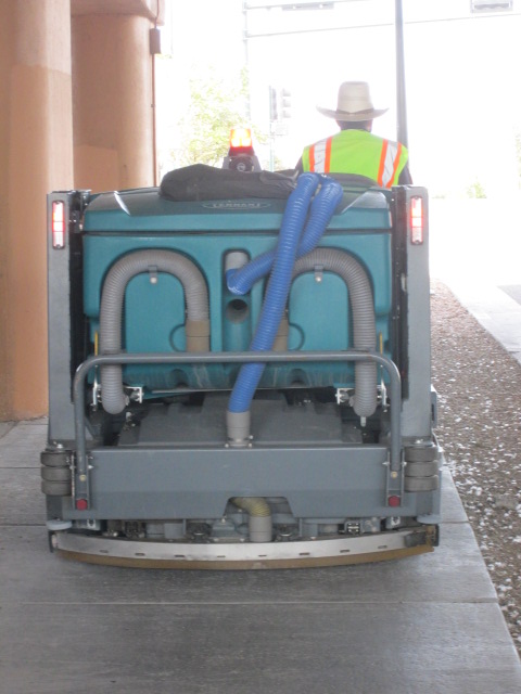
P.S.: See the cute-as-a-button device below? It’s a “mini-street sweeper,” shown below cleaning the bird poop and vodka bottles off the sidewalk at the MLK/I-25 underpass. And the City of Albuquerque has one!
Well, we now have a new job for that mini-sweeper, for, if you look closely at the photos throughout this post, you’ll notice it’s already time to sweep the Carlisle cycle track. The things you have to think about when you do something for the first time…

Wow. I hadn’t even heard about this. And I attended the Silver bike-boulevard open house in the church right next to this a few months ago.
I think the lesson learned by this horrible implementation among the vast majority of our fellow travelers will end up being:
“Cycle-tracks are stupid and dangerous.”
And that’s ashame, because they aren’t, when done well at appropriate locations. But this is likely to set back state-of-the-art bike infrastructure in Albuquerque 20 years. Pretty soon they’ll start installing sharrows. Oh. Wait.
Having ridden this Silver jog a few times, I do think they needed to do something. But a median cycle track wasn’t it. A turn lane and a refuge would have probably been just as safe or safer, and wouldn’t have prematurely doomed cycle tracks as a concept to the dustbin of history in this town before they even started.
The difficultly with cycle-tracks IS the intersections. You don’t create them JUST AT the intersections. They work best with long stretches of road with few curb cuts. Something like Indian School from Carlisle to Broadway over I-25 would have been absolutely ideal. This Carlisle/Silver choice was just incredibly bad. There was no way they could have done it well.
LikeLike
Okay. Riding it yesterday, it isn’t as bad as I thought. It covers a bigger stretch of road than I had remembered; not just a jog. That said, when about quarter of the track is gap, it’s not much of a track. I think it’s more just misnamed than useless. I’d rather call it an extended refuge and turn-lane than a cycle-track, unless there are plans to actually extend it.
There was evidence I was right about people’s opinions that it’s stupid and dangerous, however. Glass was scattered all over it.
LikeLike
“Extended refuge.” I like that designation much better. Still, it would fit the term “refuge” better if the many left turns in the gap were reduced/eliminated.
LikeLike