About a month ago, BB and readers held a brainstorm of sorts regarding bicycle infrastructure gaps. To provide context and contrast with our identified gaps, below is a list from the City’s 2015 Bikeways and Trails Facility Plan (BTFP). If you’re not familiar with the BTFP, it’s both an important planning document and something of a look “behind the curtain” into how planners view the always tough job of prioritizing goals and projects.
A close reading of the BTFP will also define what is meant by terms such as “lineal gap closure.” And now your homework.
- Read the list below;
- Refer to and read the BTFP; and,
- Compare with the gaps identified in our October BB brainstorm.
Yes, this is on the Final Exam. Show your work.
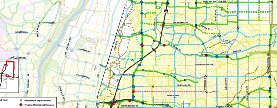
Bikeway Gap Closure Engineering Study Locations
Spot Gaps – Intersection Improvements (2 locations)
1. Central Avenue and Yale Boulevard
2. Alameda Drain at 12th Street
Lineal Gap Closure Engineering Evaluations (7 locations)
3. Paseo del Norte/Paradise Boulevard – A portion of this gap will be addressed as part of the 50-
Mile Loop project, which anticipates a paved trail along the Corrales Main Canal connecting the
existing Paseo del Norte trail down to Eagle Ranch. A paved trail will be provided along Eagle
Ranch Rd. to connect to the intersection with Coors Blvd. Some intersection enhancements are
anticipated, which will help travelers access the existing trail along Eagle Ranch that is west of
Coors Blvd.
4. Wyoming Boulevard/Utah Street
5. Montano Road/Montgomery Boulevard Corridor
6. Girard Boulevard Corridor
7. Lomas Boulevard/Easterday Drive
8. Lomas Boulevard/San Pedro Drive
9. Rio Grande Boulevard – City Council is in the process of evaluating options to close this gap.
Corridor Gap Closure Engineering Evaluations (16 locations)
10. East Central Avenue
11. Paseo del Norte (North Diversion Channel to I-25) – In conjunction with the I-25/Paseo del Norte
Interchange reconstruction, trail and bikeway improvements are in process to address the gap
between the east side of I-25 and the west side of Jefferson. They consist of a grade-separated
bridge crossing I-25, with paved trail connections on either side. Future work will extend the trail
along Headline, across Jefferson Blvd. at a lighted intersection, and north along Tiburon to
connect to El Pueblo. Improvements along El Pueblo will occur as a future project.
12. Bridge Boulevard (Coors to Broadway) – Bernalillo County recently completed the Bridge
Boulevard Corridor Plan, and is in the process of making multi-modal upgrades to close this gap.
13. Candelaria Road (12th Street to University)
14. San Pedro Drive (Zuni to Claremont) – A portion of this gap will be addressed as part of the
current San Pedro Road Diet project, which will add bicycle lanes between Mountain Rd. and
Haines Ave. Additional improvements to the parallel route, Alvarado Dr., as part of the 50-Mile
Loop project. It is anticipated that there will be a HAWK signal to assist with crossing Lomas
Blvd.
15. San Mateo (Gibson to Ridgecrest)
16. Sequoia Road (Coors to Ladera Drive)
17. Indian School Road (Rio Grande to 12th Street) – This is a current DMD project.
18. Cutler Avenue (Washington to San Mateo)
19. Claremont Avenue as a Bicycle Boulevard (Richmond to Chelwood)
20. Alexander Boulevard (Comanche to Mission)
21. Montano Road (4th Street to 2nd Street)
22. Irving Boulevard (Universe to La Paz) – This is a current DMD project.
23. Washington Street (Lomas to Zuni)
24. Carlisle Boulevard (Garfield to Silver)
25. Second Street (Stover to Marquette)
