It’s just about March, which means it’s time to get back on the bicycle and time to finish up measuring bike lanes.
I admit I’ve become quite a bit more of a fair-weather rider in the last few years, mileage per week dropping below 50 and sometimes closer to 25 in these chillier months. But it’s just about March now, and, besides, I’ve got a 3,000 km bike tour lined up beginning in June. More about that as it gets closer.
Yesterday’s ride took me to fairly far-flung spots, for me, including this stretch of Morris from Candelaria to Montgomery:
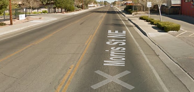
The AABLE bike lane measuring project has already collected data on this stretch of Morris, and an ugly set of numbers it is. Note the 35 mph speed limit and, even just eyeballing it, you can tell this is a substandard bike lane, running as narrow as 25 inches as one approaches *Montgomery (where, of course, there isn’t a lane at all, just as with crossings at Comanche and Candelaria).
Folks have rightly asked me “What are you going to do with data collected in the bike lane measuring project?” Morris, an important north/south bike “facility” in the Heights, is a good example of what the data might be used to accomplish.
See the cracks in the road above? See the wide continuous turn lane? Morris should be up for a repaving/restriping job soon, and when it’s done, according to the Complete Streets Ordinance, the current striping widths should certainly be changed to fit the all-user intention of the Ordinance.
But what if Morris isn’t scheduled to be restriping/repaving for years? That’s where AABLE seeks to come in and demand that priority be given to substandard bike lanes on important facilities such as this one. That is to say: Why can’t we prioritize bike lane standards as high, if not higher, than road surface or a simple timetable to renovate our streets?
Older generation bike lanes, several of them running north/south in the Heights, were created with 13-14 ft. driving lanes, wide continuous turn lanes, such as on Morris, and tiny, itsy-bitsy bike lanes. That obviously needs to change and we really can’t wait to change them according to a timetable based only on motorist’s priorities.
Complete Streets needs to pervade ALL our thinking about transportation in this city/county, including things like detours during construction and road resurfacing project priorities.
And yes, we still have some streets to measure in our AABLE project. Now that the weather has warmed, maybe you, too, are interested in helping out to finish up the 28 or so streets still left un-measured. Comment below or contact Scot in some manner if interested in finding out more.
*By the way, isn’t it interesting that one of the lousiest place to ride a bicycle in all of Albuquerque is the area immediately surrounding a huge public high school, Eldorado HS? Says something, doesn’t it?
