Note: Below is this week’s Better Burque goes Duke City Fix piece. While you’re more than welcome, eagerly so, to join the proceedings here at BB by becoming a contributor, you might also inquire over at DCF. There’s a day or two “open” there as well. So many Burque blogging options…
Today’s bike ride originated as one of those intentionally grim ones, planning to observe traffic and measure bike lanes and such on Broadway Blvd. near the site of a serious vehicle/bicycle crash a few weeks back. It ended up being one of hope, as I found a personal cycling “Yellow Brick Road” that I’m excited to tell you about.
Two apologies to start:
- Fellow experienced cyclists: Maybe you’ve ridden this route a thousand times and will just roll your eyes and say “duh” over and over while skimming the info below. Sorry.
- The cycling route described below travels through several fabulous lower income neighborhoods of our fine city. In the view of some, mixing recreational/commuter bicycle riding (particularly through improvements such as bike lanes) and fabulous lower income neighborhoods is “gentrification.” And that’s bad. And I have to admit I’m not sorry for suggesting more folks, yes even those with dorky mirrors on their bike helmets, ride this route through these fabulous neighborhoods. Still, I apologize if such a suggestion is irritating, although I most definitely think a deeper conversation and planning toward improving neighborhoods the “right way,” while also improving bike riding safety is not only possible, but a really damn good idea.
Now back to a grim ride which transformed into a hopeful one.
So I’m riding down Broadway near Coal downtown, specifically at Iron, the site of the recent crash. I don’t make it out to this area much on the bicycle, because frankly it’s never looked too inviting on a bike map. My initial view is this:

This is where the bike lane starts up southbound at Iron. Strangely, there’s a bike lane with no buffer (the little horizontal stripe section), but a buffer from the curb. Gotta protect cyclists from those aggressive inanimate curbs. This leads eventually to what may or may not be a parking lane stripe (with no cars parked along it and with plenty of bus stops). Traffic was light being a Monday late morning, but cars were definitely going over the posted 35 mph speed, all resulting in exactly the grim sort of cycling environment I had expected. On top of that, of course, the bike lane goes away here northbound up to Lead and Coal, even though the roadway widens significantly. I don’t know how/why this stretch of Broadway was engineered this way, but I thinking there’s a better way all around.
Further south the bike lane again ends at Santa Fe Ave., which is bad news because that’s just north of a school zone and South Broadway Cultural Center. So far the ride is living down to all my expectations, culminating in this view along the sidewalk (yeah, I’m riding this for a bit because riding Broadway doesn’t look like fun) at Pacific:

It’s hard to make out in the 2nd dimension above, but the nearside curb does NOT have a ramp to road level, while one exists on the other side. Across Broadway, the other two corners have ramps. Did I mention this is a school crossing intersection for kids to get to nearby Eugene Field ES (as well as the big St. Francis Xavier church right across Broadway)?
So far, so grim, so ADA non-compliant.
Then while walking the bike past one of my favorite places in town, South Broadway Cultural Center, I decide to take a detour to check out the adjacent park. A ride past that leads to one thing, which leads to another, and pretty soon I’m on Commercial St., right at the train tracks and I am presented with the following view:

Not everyone’s idea of beauty, but I find the Railyards endlessly fascinating, particularly in their current state (although fixing them up would be a smashing idea, so to speak). Things are picking up, and traffic is almost non-existent. From Commercial, I wander over to William St. and FINALLY get to the “yellow brick road” ride I’m so excited to tell you about.
Here’s a representative, at least on a late Monday morning, view of William Street:

This street, running directly parallel to Broadway, has almost zero moving cars. Why does it have almost zero cars? Because William has speed bumps. And drivers hate speed bumps. I love speed bumps. I live on a street with speed bumps and I still salute the speed bump installation gods every time my car bounces its way over one, even though I’ve been bouncing over seven of them, one way, for 17 years now.
Given the wide open nature of William St., who knows how fast people would be driving up and down this airport runway. There aren’t even stop signs for almost a mile on William. But there are speed bumps.
In addition to the speed bumps and low traffic, William has three incredible cycling route things going for it:
- It goes under Bridge Boulevard;
- Gibson doesn’t continue past Broadway; hence, no Gibson to worry about; and,
- It runs all the way south to Woodward. Here’s a Google map with little red dots and such:

Pacific/William is the red dot at the top. Now comes the mind-blowing part. See the little red line segment I’ve crudely drawn from 2nd St. (NM-303) to the ditch along the Bosque? A couple of years ago some County staff put in a little multi-use path spur from the Bosque Path to 2nd St. At the time, and until about Noon today, I thought putting this spur there was simply asking unsuspecting Bosque Path cyclists to commit suicide. 2nd Street is tough.
But now I’d like to kiss these County staffers, although I don’t think they would like that. I’d like to do so because now it all makes sense to me. William stops at Woodward. A cyclist willing to tackle the short little stretch of Woodward over the train tracks to 2nd can pop across the street, catch this little spur and then they’re on the Bosque Path.
It’s a grand unification theory put into cycling practice. We’ve ridden from near downtown without having to deal with downtown. We don’t even have to ride up the trestles over the train tracks at Coal, Lead or Marquette. Wow.
But let’s unify this even more. If we take William to Pacific, then cross Broadway to Edith, we have an acknowledged bike route (which really should be a bike boulevard) in Edith all the way past I-40 to Menaul. And, of course, Edith goes under I-40. Here’s the entire route from my little dorky guy with mirror on his bike helmet Strava map:
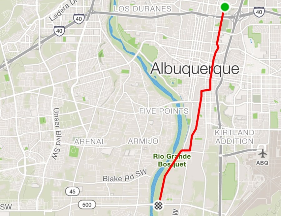
That’s Menaul to Rio Bravo inclusive in 6.5 miles, pleasantly riding through several fabulous neighborhoods in a straight shot that I think is even quicker/shorter than riding through downtown. Give it a shot, fellow recreational/commuter cyclist, if you haven’t already 10,000 times and have permanently stuck eyeballs from rolling them so often while reading this overly lengthy travelogue. To give final incentive, I’ll close (FINALLY) by showing you the Bridge Boulevard “crossing” on William. It’s so nice the City is even painting the overpass for you to pleasantly ride beneath.

Enjoy!

[…] This one doesn’t involve a call to 311/SeeClickFix. We at BB now ride Edith Boulevard east of downtown just about once a week because it is so wonderful, goes through so many cool neighborhoods, and connects with William Street, a great way to get to the South Valley that you might be tired of hearing the author gush about. […]
LikeLike
[…] the new Woodward will include multi-use path access from newly designated bike route William Street (immediately east of the train tracks illustrated below) to 2nd Street and a currently little-used […]
LikeLike
[…] I’ve written about how loverly this stretch is going back to something called “Duke City Fix.” Yes, I miss it, too. Well, despite its loverliness, there’s been a glitch at the intersection […]
LikeLike
[…] Overly long preface aside, when talking Edith Blvd. as a “bike boulevard” I can report that BB has been hyping this idea for years, long enough back that I wrote a little something about it for the long-defunct Duke City Fix seven years ago. […]
LikeLike