
To finish up our look at the 50-Mile Activity Loop, after having ridden it on New Year’s Day and having posted about it here and here, let’s toss around a few tentative ideas that address an overarching Loop question:
Is this anything close to the best possible 50-mile Loop in/around Albuquerque?
Our rules are pretty simple:
- It still needs to be 50 miles.
- Loop shape needs to be as close to a loop/circle as possible, keeping in mind the existing Loop isn’t perfect in that regard, either.
- Today’s post is just a starting point; there’s still plenty of mileage calibration, debate and other details to be worked out.
In today’s tentative re-design, let’s start with what we’re keeping:
- Start/Finish is still downtown
- Moving east first, we keep Silver Bike Boulevard and much of the Alvarado stretch, before a slight revision in Fair Heights
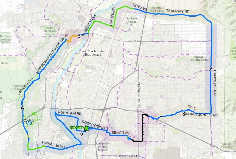
- And, most importantly, the existing Loop segments from the Zimmerman/Dakota (the Tom Bolack Urban Forest Park) at I-40 up to Tramway, and around Tramway all the way north and back west to Alameda and the Bosque Trail stay intact)
Hence our proposed changes are principally on the Loop’s west and south sides. Before getting to those, let’s start with a slight change made possible by….
Proposal Number One: Fair Heights Bike Boulevard

Here’s the existing Loop, taking folks east to Morningside, then to Coal/Zuni to Alvarado. This made sense before the Fair Height Bike Boulevard, but doesn’t any more:

Here’s a graphic made by a kind Better Burque reader which shows the new Fair Heights Bike Boulevard route. So our proposal is to revise the Loop eastward to Silver/Monroe, catching Fair Heights BB at its southern terminus, taking Fair Heights to Zimmerman/Dakota at the park.
If you get a chance to ride both, I think you’ll agree this is a safer and saner route. Although I love the idea and execution of buffered bike lanes on Zuni, as well as the idea of taking the Loop through a neighborhood that needs to be seen and experienced by folks from all parts of town, Fair Heights is by far the better option.
I haven’t done the geography/math, but know this new route shaves a mile or so off the Loop total. Fortunately, we’re going to add about two miles in our next two recommendations.
Proposal Number Two: Bridge to Atrisco to I-40 Trail to Ladera
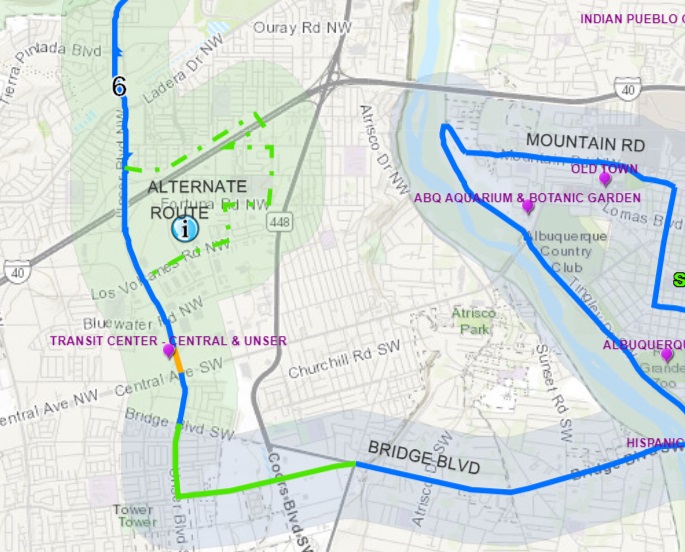
Here’s the existing Loop route west on Bridge over the River to first Tower, then taking Unser beyond this graphic to just past Ladera. And here’s our proposal, using the beautiful (and yes, hilly) Atrisco section between Central and I-40, which overlooks the City, as well as the bike/ped bridge at Atrisco/I-40, and the I-40 trail to get us from Coors to Unser/Ladera:

Working out the distances, I get 8.3 miles, as shown above, on this new route, while the original Bridge to Tower to Unser to Ladera works out at 6.9 miles. Actually, it would be closer to 8.1 miles, as I’m using 8th Street as a starting point, which is a tad east of where one would take the Bosque Trail/Bridge intersection instead.
So we’re talking about 1.2 miles extra, which is roughly how much we save by using Fair Heights Bike Boulevard. Admittedly, I haven’t worked distances out precisely, and we do want to be precise, but, as we work towards that, consider how much safer, saner and (no offense to folks living near Tower and Unser) more beautiful riding this proposed route would be, in either direction, than the existing southwest Loop segment.
What some may see as the biggest obstacle here, is actually the biggest attraction. Namely, the steep hill up Atrisco north of Central. Why is this actually the single biggest reason to change the existing route?
- Atrisco now has buffered bike lanes that we cyclists love;
- The view from atop this hill looking over the city (insert beautiful photo here..sorry I don’t have one at present) is one of the finest in all the land;
- Atrisco connects directly to a bike/ped bridge over I-40, instead of the extremely uncomfortable current crossing of I-40 at Unser; and,
- Atrisco is one of Albuquerque most important historic neighborhoods, and right now the 50-Mile totally bypasses it.
Proposal Number Three: Undefined Way to Get From Unser/Vulcan to Bosque Trail
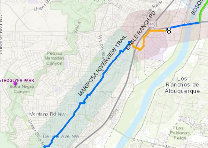
The upshot of Proposal Number Three is that we don’t, yet, have a proposal. All Better Burque, and everybody who has yet tried the northwest section of the Loop, can tell you is that getting from Mariposa Trail across Coors to the Bosque Trail is a bit of a nightmare. It’s pretty undeniably the most dangerous stretch, particularly when the long-awaited Bridge Boulevard project is complete (and we switch to our proposed Atrisco segment).
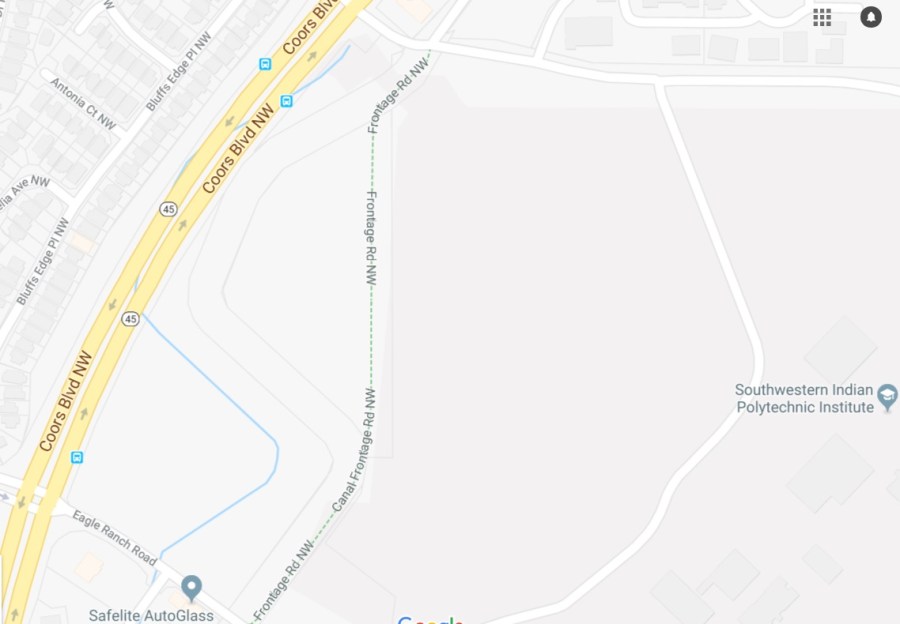
There’s also the fact the Loop isn’t done here, with a currently unpaved section at “Canal Frontage Road” near SIPI (although I guess the idea might have been that there would be a perpetually unpaved section of the Loop):
Any ideas on how to best chart a route through all this are deeply appreciated. I don’t live up in that part of town, and because it’s so unfriendly at present, only ride it on days where I make stupid declarations to ride the entire 50-mile Loop. Something definitely needs to happen, but we at Better Burque don’t have the foggiest what that might best be.
On the other hand, Proposals Number One and Two above are pretty exciting, at least to Scot/me. If you’ve ridden the Loop and proposed alternatives, I’d love to hear what you think about it. If you haven’t, I very much invite you to do so, particularly the Atrisco segment. Yes, there’s a hill, and yes, there’s a need to improve the “bike route” at present from Bridge/Atrisco to Atrisco/Central, but that buffered bike lane and City view are pretty fantastic.
One advantage of the Loop signage being inconsistent and/or bad at present is that it offers us a chance to revise the Loop. Any input and help you can offer toward that end, even if you prefer the current Loop, is much appreciated.
