
This past Sunday John and I rode out to Arenal Road Southwest, site of an upcoming City of Albuquerque road project. For those who don’t make it out there much, here’s Arenal Road (look for the red) in context:
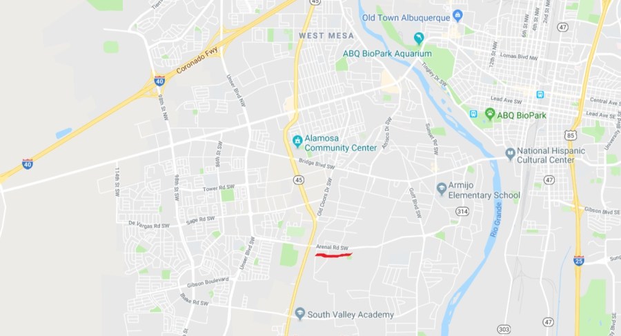
Yeah, we’re talking way down South to most Burqueans’ way of thinking. Arenal Rd. is in a unevenly growing part of town, transitioning from centuries-old farms around Rio Grande High School in the Valley, to myriad subdivisions coming up from the South Valley floor to the Southest Mesa to Unser Boulevard and beyond.
Arenal Road is like many streets/stroads the SV, a place that sensible long-term road engineering and urban planning seems to either kinda forgot or at least constantly kept changing its mind. Arenal widens and narrows more than once as it goes west from Isleta Blvd., and, by the time it peters out west of Unser Blvd., goes from skinny bumpy two-lane road, to wide bumpy four lane with massive curb-raised median, back to bumpy two-lane road.
 Arenal Road in its wide bumpy with increasingly massive curb-raised median guise across from Tom Tenorio park between Coors Blvd. and Unser Blvd.
Arenal’s primary connecting feature is its bumpiness (see cracks above), hence parts of it are to receive City “heater scarification” and “micro-surfacing” in 2018, or at least 2019. Conversations are ongoing to find out more regarding an actual start/finish date.
The short explanation of what the heck “heater scarification” and “micro-surfacing” mean would be to simply say that these bits of Arenal are getting resurfaced. For those wishing to delve into the world of road construction treatments, here’s a You Tube video (that rather inexplicably has 3,122 views) about heater scarification and micro-surfacing, and here’s a 22-page document, with twenty-seven eight-by-ten colored glossy photographs with circles and arrows and a paragraph on the back of each one, so to speak, from the City of Nashville explaining road construction perhaps more fully than you might have time for, at least in this lifetime.
So good, Arenal is getting fixed! It won’t be nearly as bumpy, both in its wide and narrow spots. All will soon be well down here in the deep South Valley and Southwest Mesa.
Uh…not exactly.
You see, the pending job on Arenal Road is a City project, and Arenal is one of many roads around the area that wind through both County and City sections; in fact, Arenal is like several roads is that the street itself becomes the dividing line between County and City.

Here’s Arenal Road on that really cool ArcGIS map from City of Albuquerque. I’ve put little crude red circles at its termini (Goff/Isleta to the east; just past Unser to the west, where it actually changes name to “Sapphire St. S.W.”).
The light green area to the east is “Unincorporated Areas” (i.e., Bernalillo County). This includes, as you note, Arenal at Tom Tenorio Park. West of the light green is City of Albuquerque.
So….
If City of Albuquerque wishes to finally “Heater/Micro” Arenal, it’s only going to do so, obviously, within its jurisdiction. So the pending Heater/Micro (which would make an excellent band name in the “Sleater/Kinney” vein, by the way) is only going to address the stretch starting somewhere around Tom Tenorio Park (it’s confusing, because it’s the dividing line) west.
To further complicate things, I’ve chosen to add a GIS layer on the map above identifying, through dashed black and blue continuous lines, streets that are scheduled/planned/proposed to have bike lanes in the 2040 Long Range Bicycle Roadway Map. As it’s been a few hundred words, let’s show that GIS map again:
Hmmm…You might notice that both the County and City parts of Arenal between Coors Blvd. and Unser Blvd. are supposed to have bike lanes in the “2040,” so to speak. This gets us back to another previous photo, our shot taken precisely where we go from County to City westbound at Tom Tenorio Park:
See? See where the line appears to be between County and City? It appears to be precisely where that bike lane unceremoniously, one might say “unincorporatedly-meets-incorporatedly” ends.
One thing that would help garner a better overall understanding of Arenal would be to find out what year the County did the striping job above, terminating bike lane included. Research on that is ongoing.
Moreover, work and research is also going into how we might better generally coordinate road improvement jobs on streets that exist in both City and County, e.g., Bridge Boulevard, Sage Road, and Blake Road. While more of the history needs to be understood, it looks pretty clear that infrastructure in the southwest part of town has suffered in past decades due to a lack of such coordination.
Older timers to ABQ remember efforts over the years to “unify” City and County, including an unsuccessful (58% No; 42% Yes) public vote on unification back in 2004. Hearing of zero energy toward giving formal unification another go, we’re going to need to work more broadly and more informally to overcome resultant government structural deficits that have led, through no real fault of any person or entity, to streets like Arenal Road in 2018.
Meanwhile, when John and I rode Arenal westbound Sunday and got to the abruptly terminating bike lane, we made a rare decision to just ride the sidewalk. It was that uncomfortable on the road itself, even on a Sunday morning. We’re looking forward to tackling Arenal again, post-Heater/Micro, strongly hoping that bike lane still doesn’t just suddenly end when we do.
