
An interesting KRQE story by Chris McKee on Kirtland AFB’s idea to use some of its unused land to provide a “Gibson Flyover,” changing the route of Gibson Blvd. at Louisiana northeast to Eubank in a route haphazardly shown in red below:
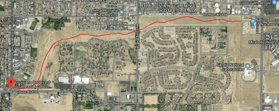
No, if built, the road will probably not be quite this meandering (blog poster mouse skills ain’t what they used to be), but you get the general idea.
Speaking of ideas, as Mr. McKee notes in the story, thoughts around extending Gibson Blvd. have been around a very long time. Taking advantage of a rare chance to quote myself, here’s an excerpt of a BB piece cross-posted at ye olde Duke City Fix about a year ago. We start with a look at a snippet of a 1960 USGS map of Albuquerque:

Miles Road (now Gibson Blvd.) does extend into East San Jose in 1960, stopping at Broadway as it does today. You may or may not know that serious plans were proposed to extend Miles/Gibson west across the tracks and River all the way to Coors Boulevard. In fact, a bit south plans called, at one point, for an intriguing SE loop segment of Rio Bravo all the way around (now it would be through) Kirtland AFB to Tramway. Here’s a look at both proposals from the “Long Range Major Street Plan” in 1983:
How would ABQ be different, both good and bad, if either/both those two projects had happened? Anyway, going back to 1960, South Broadway neighborhoods don’t even have Stadium Blvd. (now Avenida Cesar Chavez) yet. East/West connectivity between these neighborhoods and the rest of town just doesn’t exist between Coal and Gibson, in either direction, and westerly all the way south to Rio Bravo.

Neither the far south Rio Bravo extension through KAFB (think stored nuclear weapons) or Gibson extension over the River to Unser (think strong opposition to bridge over railroad tracks & River, and other factors) have happened over the years, and you can also see the dashed line running SE in the “Long Range…” map above, from what looks like San Mateo & Gibson, that would have somehow met up with the proposed Rio Bravo loop. Of course, the “new” proposal from KAFB focuses on land north of Gibson instead.
This new variation includes a “Wyoming Flyover.” One’s faith in the plan is somewhat dented, however, by the spelling of “Louisianna” in the illustration:

One also notes the 2016 date on the mock-up; again, these plans have been around in various guises for decades. Who knows if this latest idea will “fly” (get it, Air Force Base, “flyover,” I’ll stop now), but it does remind us of the view at the current, and currently obscure, western terminus of the on-again/off-again road known as Gibson Boulevard, way out in far SW Albuquerque:

Here’s a birds’ eye look:

Yeah, right now Gibson stops at what will/might be/probably should never be…:

Planners gotta plan; developers gotta develop…
