by Scot (My Duke City Fix piece for this Monday cross-posted)
DCF readers who have glanced over at my other bloglette, Better Burque, know I’ve been obsessing researching lately how Interstate 25 served to further isolate Barelas, San Jose and nearby neighborhoods already bisected years earlier by the railyards/train tracks.
The arrival of steam trains through Barelas had significant, and mostly positive, economic impact on the area, but the switch from steam to diesel trains meant far less need for repair, and the Railyards we see today are stark reminders of the result.
 Looking west at the Railyards from Commercial Street as it winds around a Water Authority catch basin

Of course, many nearby residents worked for the railroad, as repairing machinists, boilermakers, porters and in the retail shops lining the facility. The economic impact of the closure continues, even today, to affect the neighborhoods.
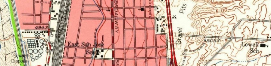
One reason for that continued effect is that neighborhoods such as San Jose have been split from north to south, repeatedly. The banner atop this post is a snippet from the 1960 USGS map, found at this really cool place for historical maps. Did you know Burque’s sewage treatment plant used to be between what is now the Bueno plant just south of the National Hispanic Cultural Center and the ball fields along the Bosque Trail? More about that in a bit. First, let’s take a bigger look at that 1960 map:

Doing a bit of what we might call “sociological cartography,” there’s a lot going on in this map, and most of it ain’t good. In addition to “sewage disposal,” the neighborhood is being split, again, by the under-construction I-25 (that construction noted by the dashed red line segments), a series of “gravel pits” further separating what were then known as the Sand Hills, as well as the remote Kirtland Addition and Lowell School (now ES) forlornly stuck out on the edge of this map. A look at the East Map for 1960 shows that Lowell School really was in the middle of nowhere.
Miles Road (now Gibson Blvd.) does extend into East San Jose in 1960, stopping at Broadway as it does today. You may or may not know that serious plans were proposed to extend Miles/Gibson west across the tracks and River all the way to Coors Boulevard. In fact, a bit south plans called, at one point, for an intriguing SE loop segment of Rio Bravo all the way around (now it would be through) Kirtland AFB to Tramway. Here’s a look at both proposals from the “Long Range Major Street Plan” in 1983:

How would ABQ be different, both good and bad, if either/both those two projects had happened? Anyway, going back to 1960, South Broadway neighborhoods don’t even have Stadium Blvd. (now Avenida Cesar Chavez) yet. East/West connectivity between these neighborhoods and the rest of town just doesn’t exist between Coal and Gibson, in either direction, and westerly all the way south to Rio Bravo.
And there’s also the sewage treatment plant. As described by Rudolfo Anaya in Heart of Aztlan, we’ll close this preliminary background piece toward solutions with what it was like to live in Barelas in the time period, both the very good and the very smelly:
Smiles were in the soft air, and so was the fragrance of roasting chile verde and hot tortillas, supper for the hungry workers. The air was heavy with the damp smell of just-watered gardens, dirty with the bad smell of sewage that drifted up from the sewage plant in South Barelas, and acrid with the salty sweat-smell of the grimy workers from the railroad yard.

[…] has been much whining, history and more whining here and elsewhere about the fact that Interstate 25 between Coal and Rio Bravo […]
LikeLike
[…] Gibson Blvd. have been around a very long time. Taking advantage of a rare chance to quote myself, here’s an excerpt of a BB piece cross-posted at ye olde Duke City Fix about a year ago. We start with a look at a snippet of a 1960 USGS map of […]
LikeLike
[…] at BB than anything other than pedestrian fatalities. Namely, you can read about it here, here, here, here, here and […]
LikeLike