Emailed comments on the draft “Connections 2040 MTP” long-range transportation plan update mentioned frequently here at BB in recent weeks are due by 5:00 PM today, Thursday, February 6th. Here’s that email address.
For those interested, and there might not be very many, below are the comments passed along by your humble blogger earlier this morning. One of those “I’ve suffered for my verbosity, not it’s your turn” things. If the tome below is deemed very much TL:DR, the hyper-short version is: This thing needs work. Lots of it.
- There were a record 103 traffic fatalities in Bernalillo County last year up from around 60 or 70 as recently as 2012. This fatality rate growth is much higher than has been our growth in vehicle miles traveled or our population during this time period.
- The Target Scenario, Chapter 3, is core to this entire update, yet that Target Scenario doesn’t include safety/reducing traffic deaths/injuries as a regional challenge or guiding principle. This is an oversight that definitely needs to be corrected.
- Aside from Chapter 5 on Active Transportation, little to no mention of how dangerous our roadways are can be found anywhere else in the draft. Cases of traffic death/injury are happening to all roadways users, drivers included, in record numbers, not just those cycling, walking, or taking the bus, the modes of travel emphasized in Chapter 5.
- Chapter 4 on Optimized Mobility essentially defines “optimal” solely as getting from Point A to Point B as fast as possible with optimally minimal congestion. Getting to Point B alive or uninjured is evidently not considered an aspect of “Optimized Mobility.” This would be humorous if the issue were not so serious.
- It is worth noting that Albuquerque ranks as 44th most congested city in the United States, with commute times lower than other cities, even those of similar size such as Tucson.
- So, to sum these first few points up, the draft currently reads very much like separate documents written by at least two separate groups of folks with differing agendas and foci. The focus on safety and traffic fatalities/injuries in Chapter 5 needs to be a focus throughout the plan, very much including the Target Scenario. The pronounced focus on congestion throughout the rest of the draft is unwarranted to its current extent. All of us hate to be stuck in traffic, but we are currently stuck with a roadway system leading to record numbers of dying/injured roadway users, not record levels of congestion. Finalizing a long-range plan than relatively ignores this fact may very well be another factor in extending this unfortunate reality.
- Finally, as a draft, many sections are understandably still incomplete, including specific performance measures and quantified goals to be crafted after these public meetings. Unfortunately, I don’t think there will be any chance for public feedback on those to-be-determined crucial measures/goals, and it’s hard to fully assist in this process without seeing those measures and goals. I understand that there is a bit of a time-crunch to meet a June 2020 federal deadline. This is quite unfortunate, and we need to realign future draft processes to better meet deadlines while providing sufficient time for public comment and involvement in development of specific performance measures and goals.
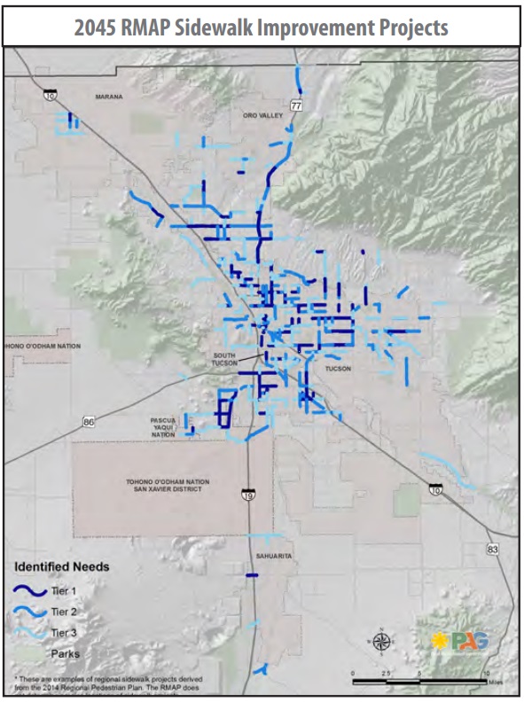

The following table of sidewalk segments and maps represents the highest scored sidewalk segments resulting from the use of the GIS-based pedestrian demand model developed for this Plan. Segments are limited to major roadways in the region. Other pedestrian-need locations have been included as high-need segments at the request of PAG member jurisdictions. The following tables are not an exhaustive list of all segments lacking accessible sidewalks, rather they represent only the top scoring segments in each of the region’s jurisdictions. Sidewalk status and accessibility data come from the 2012 ADA Sidewalk Inventory, which is current as of October 2011.
The data are presented at the segment level, not at spot locations; therefore if any spot location (such as a single curb ramp) along a segment is not accessible, the entire segment will be treated as inaccessible for this Plan’s purpose. These tables of identified needs are the result of an effort to provide a regionally-standardized method for proactively identifying needed pedestrian improvements. They are to serve as guidance and support to PAG member agencies in developing their own plans, Capital Improvement Programs, and as they submit for regional funding for pedestrian improvements. Tables and supporting maps are presented for each of the region’s jurisdictions. These do not represent a list of projects. The table also does not consider additional improvements, such as street furniture, shade, traffic calming, safety projects, or other elements that contribute to making public rights-of-way safe and enjoyable for all users. This Plan encourages incorporating those pedestrian safety and comfort concepts presented in the toolkit into individual pedestrian and roadway projects where appropriate.
- Identifying needs in each jurisdiction throughout our MPO;
- Prioritizing those needs;
- Including results of this process in our long-range plan update; and,
- Using those results to guide decision-makers throughout our MPO in funding desperately needed, highest-priority improvements.

[…] the driver. Roadway fatalities are painful for so many, and are happening in our City/State in record numbers. We’re not going to truly address this public health crisis until we stop blaming victims, […]
LikeLike
[…] right around the time K-12 schools in New Mexico are currently scheduled to re-open. If interested, here are a some comments BB made regarding the earlier […]
LikeLike