
Given the astronomical increase in cycling interest these days (have you visited your local bike shop lately? It’s “kray-kray” to use the parlance.), I’m thinking I have a billion dollar idea: A 30-minute deeply investigative documentary series in which just regular folks who bike to work engross millions of cycling-mad viewers with turn-by-turn analysis of their well-curated commuting route.
There will be many graphs/maps and a basic recreation of that meme, you know the one:
But instead of a wide-striped tie, Charlie Kelly would be wearing a bike helmet.
Ah, okay, I’m kidding. I know bike commuting isn’t quite that popular, complete current inability to get tires/tubes in any size other than 26 inches by 8.25 inches notwithstanding. Maybe the show would just be a podcast instead of on HGTV or other “on-air” network.
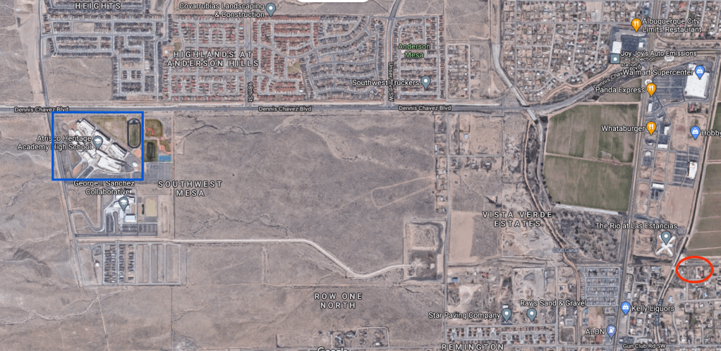
But as I’m guessing there’s at least one BB reader not named Scot who IS interested to an obsessive degree with how cyclists figure out the best, absolutely best, monster-genius route to/from their workplace, let’s unravel a riddle: Using the birds’ eye screen grab below (and any other resources you wish), determine how Scot gets to/from his new workplace.
Does BB take (you’ll need to click the image above to play):
- Coors to Rio Bravo/Dennis Chavez?
- Gun Club (look closely)?
- Some route way north and around the horrible Coors/Rio/Bravo/Dennis Chavez cluster?
Well, obviously, the answer is none of those, and I’ll stop listing them to give you more room to manically plot routes, or, if you’re really interested, head out to the far South Valley and experience Coors and Rio Bravo on a bike for yourself.
For there’s a huge amount of “local knowledge” involved here, as there is with all such routing. Every serious bike commute route has at least one squiggy, turn or portage that nobody in their right mind who hasn’t experienced the area would ever consider. That’s one of the million reasons a nerdy captivating show about the topic would make a great 30-minute show (or podcast, if absolutely necessary, but where are you gonna put the maps with squiggies on a podcast?).
Feel free to put answers/suggestions in the comments here or anywhere else they might be found.
Enjoy and good luck!

Are there any buses that go part of the way?
LikeLike
Michelle: Looking at the 198 Bus Route schedule: http://data.cabq.gov/transit/Maps/198-wkend.pdf/view
It appears that the stop at Atrisco Heritage HS has resumed with APS re-entry. Unfortunately, it also appears that the stop at Rio Bravo/Coors (where I would be getting on/off) isn’t available on the single run/stop to Atrisco Heritage HS each morning and afternoon. Thanks for asking!
Scot
LikeLike
Google Maps suggests you ride up Coors and then take a left on Rio Bravo/Dennis Chavez. Have you tried that?
LikeLike
Jr: I wouldn’t, and don’t, DRIVE up Coors and take a left on Rio Bravo/Dennis Chavez. Maybe I would, if driving an Abrams Tank or the Batmobile (shields up…does the Batmobile have “shields” or is that only in “Star Trek”?).
LikeLike
I’m guessing you put knobby tires on your commuter bike and went all-in on gravel routes.
LikeLike
Many solutions were tried, including hauling the bike up from the street to the lined arroyo shown on the map. That route worked except for the hauling part and the goatheads. Ultimately, I ended up changing workplaces, in part because this commute never worked out.
LikeLiked by 1 person