
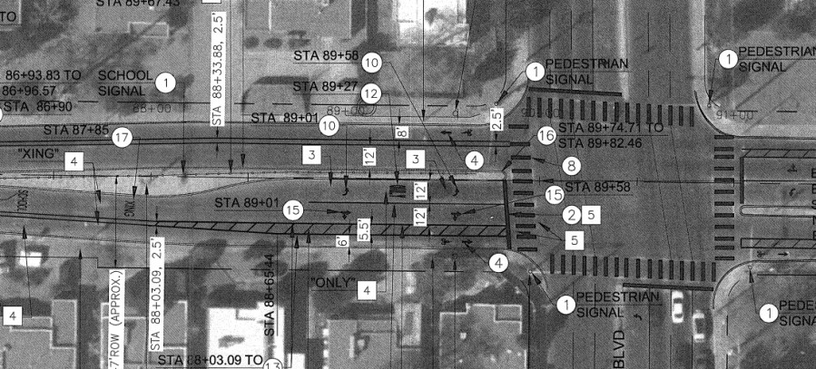
(Update, 2:52 p.m.: The Girard project plans are now available online. Here’s a blow-up screenshot of the Girard/Lomas intersection mentioned later in this post:)
On my way riding to last night’s Girard Blvd. “Complete Streets Master Plan” public meeting, I couldn’t stop smiling.
Why?
Because Girard is my absolute favorite street in town, both as cyclist and resident of our fair city/county, and the thought of it going back to its residential street roots is a very pleasant one. If you think about it, entities such as the Walgreen’s at Girard and Central are really interlopers in what is, fundamentally, a very residential corridor. For instance, you’ve got (going North to South):
- Residential areas throughout;
- Important east-west bike lanes at Indian School and, another personal favorite, Constitution;
- Summit Park just off the corner of Girard and Constitution;
- Adjacent access to UNMH and the Law School via Marble and other streets;
- Jefferson Middle School and its cross-street neighbor First Congregational United Church of Christ;
- A skip-and-a-hop to Monte Vista Elementary at Campus;
- UNM and its prime outdoor space, Johnson Field nearing Central;
- The nearly unbeatable residential combination of Ernie Pyle Library, Hyder Park and Bandelier Elementary near Santa Clara; and,
- Puerto Golf Course approaching Gibson, offering some greenery (and zero driving entrances/exits) for a solid stretch.
Truly a delightful road, right down to Girard’s relatively un-ABQ hilliness, offering a change-of-pace from the simple “going up, going down” Burque motif from Valley to West Mesa/Sandias.
All this said, I’m probably not alone in almost forgetting Girard really is a residential street.
I worked on Girard for about 12 years (Jefferson Middle School), bike commuting, on average, three times a week, and can report the only snippet of Girard I would EVER ride was the left turn from Lomas onto the street for the 64 feet until I hit the JMS teacher parking lot. Coming from the South Valley, I NEVER thought of taking Coal to Girard on a bike, yet this was precisely what I did driving.
Because Girard, in its current, a-residential guise, is for driving, not walking/cycling.
The off-again, on-again Girard “Complete Streets Master Plan” seeks to take the wolf’s clothing off and return Girard to a sheep-like multi-modal placidity. And that very much puts a smile on my face.
Here’s the obligatory photo from last night’s public meeting (I’d like to say it’s blurry to protect those participating, but I’m just a lousy photographer):

You can just barely, amid the blur, make out the project drawings. To be honest, the drawings were a bit hard to decipher, but plenty of CABQ staff was on-hand to guide one through the particulars. Speaking of those particulars, I was told the drawings will be up “today” on the Project webpage. Keep hitting refresh.
Improvement highlights include:
- Bike lanes in stretches wide enough for them (with buffers); sharrows in the narrow portions, particularly south of Central;
- The now-typical narrowing of driving lanes;
- Pedestrian crossing enhancements; and,
- Implementation of more advanced improvements (e.g., wider buffers) at currently dangerous intersections.
This last bullet gets me to another personal story/bête noire, the intersection of Girard and Lomas. I mentioned above I’ve pretty much NEVER ridden a bike on Girard, even though it was my jobsite for a dozen years. Instead, I drove Girard, including northbound across the Lomas intersection. Here’s a photo of that intersection taken from the bottom of the “hill” at Campus:

While teaching middle school can be scary, the absolute scariest part of my day was watching kids wobble their bike up this hill at four or five miles an hour, surrounded by impatient rush hour drivers, many of whom were parents desperate to drop their kid off at Jefferson. The worst was “trash day,” with residents often putting their trash bins on the gutter itself, further reducing any space to wobble up the hill.
A compound word starting with “cluster” comes to mind when describing this situation.
I often played “automobile as buffer” in such cases, driving as slow as possible behind the cycling kid (or even adult) to make sure they could make it up the hill and onto relative safety north of Lomas.
Plan drawings show the Girard project currently proffers a solution to this, via removal of a driving lane, a nice wide bike lane and increasingly-wide buffer (6 ft. lane; 5.5 ft. buffer as I recall). Such multi-modal care is present throughout the project, and while all users will want to take a look and chime in with comments/questions/concerns, the Girard Blvd. Complete Streets Master Plan might have an overly long title, but generates a smile in its promising ideas toward reverting Girard to rightful residential street status.
There’s still a ways to go in implementing the Plan, including, as always, budgetary concerns in these New Mexico wintry economic times, but I’m already day-dreaming of a ride up Girard all the way from Gibson, with stops at Ernie Pyle Library, Johnson Field, and even the formerly cycling-uninhabitable intersection of Girard and Lomas.
P.S.: Special Cycle Nerd Fun Time “Yellow Brick Road” Edition/Epilogue
Here’s how I avoided taking Girard to get to Jefferson MS for 12 years, bike commuting three times a week. Going to school, I rode up bumpy, very bumpy Campus to CIRT, then took this alley to Lomas.

Believe it or not, riding Lomas itself to Girard, even uphill, was far safer than taking Girard. In the afternoons, I crossed Lomas, rode the freakin’ sidewalk (yes, the sidewalk) on the south side of Lomas to the famed “Vassar Dinky Gap”:

As “The Boss” once never said: It’s hard to be a cycling saint in the city. While I was far too impressed with my guerrilla ingenuity in this “yellow brick road” avoidance of Girard, I would have much preferred using the street. And I would have VERY much preferred not watching those kids ride up that hill unprotected (especially on “trash day”).
