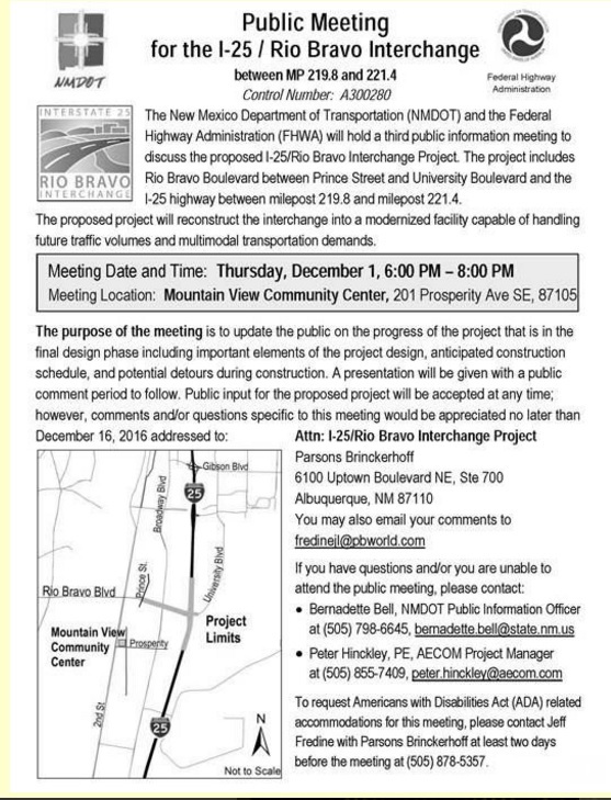
We here in the deep South Valley have a big traffic change coming. After much delay and some half-ass interventions, Rio Bravo at I-25 is finally getting a complete rebuild. There’s an open house and public meeting tonight (details on a flyer below) to outline the final plan and the road closures/rerouting involved in making this happen.
Meanwhile, a somewhat concomitant study has been commissioned by the New Mexico Department of Transportation (NMDOT) to look at the entire stretch of I-25 south of I-40 to Isleta, Rio Bravo, of course, included. This “South I–25 Highway Operations Study,” looking at how this stretch might evolve all the way out to 2040, has just come out with its final report and executive summary.
A deep South Valley resident myself, all this has me thinking about cycling gaps. Much of the discussion here at Better Burque over the past 11 months can be summed up as an examination of cycling gaps. Directly or indirectly, gaps are definitely a focus:
- We’ve brainstormed gaps
- Identified de facto gaps (and infrastructure strengths) through our look at bike lane widths around town
- Conducted mini-case studies of gap-level inadequacies such as 2nd St. between Bridge and Coal
- And presented a bit of a lecture on how a gap might be overcome via evidence and advocacy
Thinking back now, it’s funny and revealing that BB doesn’t really talk much about the absolutely biggest cycling gaps in town, namely: Crossing Our Interstate Highways.
There are exceptions. Indian School has an overpass of I-25 that is pretty pleasant, North Diversion Channel gets you across I-40 and I-25 nicely, the new MLK and Lead/Coal crossings of I-25 are big improvements, and bike/ped bridges are decently numerous and placed along I-40 east of I-25 . But then there’s the rest, particularly the quadrants of crossing I-40 west of I-25 and I-25 at and north of I-40. It’s a tough call, but a crossing-by-crossing look offers this stretch of I-25 as a formidable candidate in any “Oscars” of terrible:
- The Big-I: Obviously there wasn’t a cyclist within 50 miles of any meeting/planning that led to that. None.
- Menaul: Are you kidding me?
- Candelaria: This one is so bad your humble blogger felt it too unsafe to photograph/measure the “bike lane.”
- Comanche: It’s so bad that many cyclists “prefer” this awful one to others nearby.
- Montgomery: Everybody takes North Diversion Channel instead, then zig-zags back to Montgomery/Montano because the crossing itself is impossible.
- Jefferson: No way.
- The Informally Named “Cliff’s” or “Gentleman’s Club” Bike/Ped Bridge: Already falling apart, this new monstrosity is a particular embarrassment to everyone and leads cyclists on a confusing/winding route once they have successfully, finally escaped its dilapidated awfulness.
- Osuna: Not on your life.
- Paseo del Norte: Books could, and should, be written about this one. It’s new, yet already a legend of bike/ped user unfriendliness. It’s almost like the haste to make northern ABQ drivers/voters happy was done at the expense of cyclists and pedestrians here. Nah, that’s impossible, right? That couldn’t be the reason this crossing is so bad…
- Alameda: This one pisses your humble blogger off the most, for the cyclist coming from the Bosque Trail goes from totally wonderful from Rio Grande Blvd. to 4th St., to choosing to ride a little dirt single-track (because there’s no sidewalk) because it’s so bad as you get to I-25.
- Roy/Tramway: All things considered, this one isn’t bad. It’s a popular cycling option, leading to the even more popular alluvial fan that is the challenging grade up Tramway. Still, it’s higher quality is more due to lower traffic counts than any designed bike infrastructure.
This gets us back to tonight’s public meeting on Rio Bravo and the “South I–25 Highway Operations Study.” In sum, how can I-25 south of I-40 not end up as cycling horrible as I-25 at and north of I-40? The Rio Bravo re-do and creation of brand-new crossings at Sunport, Mesa del Sol and elsewhere offer great opportunities to not repeat the mistakes made further north.
Those interested in such things might check out the Study links above, as well as the Rio Bravo Interchange project documents webpage. As a teaser, here’s one view of the “preferred alternative” for Rio Bravo, looking east from, basically, the top of the hill near Mesa del Sol and such.

Maybe I’ll see you tonight and we can discuss whether the above is a significant improvement on those north of I-40 debacles. As you can see, the complexity of these crossings, the biggest reason many of them are poor from a cycling perspective, require quite a bit of staring and study. Still, the time taken now to eyeball, digest and take advantage of any chance for involvement in such plans might well be worth it in terms of avoiding repeats of the extreme gap horrors listed above.
Here’s the info on tonight’s meeting (thanks to BikeABQ for having this flyer in electronic form):