by Scot
Where was I? Oh yes, yesterday I promised a second part to our look at the 2016 I-25 South Corridor Study and how it applies to Lead Avenue. Apologies that yesterday became today, which certainly sounds like a Beatles album title, the one with the greatest cover ever, but all that would be digression and let’s instead continue our examination of the Study and the future of Lead Ave. immediately.
Let’s start with another look at the Study’s proposed crossing of I-25 at Lead:
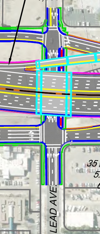
The Study denotes the dark red strip shown above as a “cycle track” (no mention of it being two-way) between the two frontage roads/off ramps on either side. There’s no mention of what sort of protection/separation will be offered in this tiny stretch, but the bigger point is one universal to all Interstate crossings: The problem isn’t under the Interstate, it’s the frontage roads and on/off-ramps.
In the case of Lead Avenue, the danger is particularly acute on the east side of I-25 at Oak Street. Just as is the case now, the Study graphic indicates a bike lane in-between driving lanes to go straight and the oft-used right-turn lane to get on I-25.
And between that red light at Oak and the proposed cycle track there’s nothing. No green paint, no dashed lines (particularly needed as the bike lane to cycle track is off-set). Nothing.
Not a damn thing.
Same for the off-ramp/Locust crossing on the east side of I-25. Nothing but a hearty “good luck” as the rider exits what will surely be a fabulous 40-foot cycle track to head further down the hill to downtown.
There is a certain honesty in proposing such a limited solution to the Lead Avenue I-25 crossing in a long-term Study such as this. That honesty is centered in:
A. We have no idea how to make such crossings safe; or,
B. We have no interest in doing the massive reconfiguration needed to make such crossings safe.
Meanwhile, Lead Avenue’s formal consideration as extension of the Silver Bike Boulevard on the 2040 Long Range Bikeways Plan is the only reason for the scant cycle track in the first place. Looking through the entire 200-page Corridor Study, one finds no similar treatment, however inadequate, like Lead proposed for any of the existing or new crossings all the way from I-40 to Broadway.
Lead is the “special one.” The rest, including future new crossings such as Sunport, get bike lanes, and pretty much leave frontage road crossings to more of that hearty “good luck” degree of engineering. Some clover-leaf danger points, such as at Gibson, are eliminated, but the most striking shortcoming in the Study’s look at the entire stretch is:
Nowhere is there a recommendation for a bike/pedestrian bridge across I-25.
Compare this with the existing I-40, which has a series of very important bike/ped crossings from residential streets and I-40 Trail paths. Heck, there’s even a newish such bridge on I-25 north of I-40 now. That a long-term study, one including highway projects that will not be completed until not only I’m dead, but quite a few folks in that group unfortunately called “millennials” are likewise gone, doesn’t call for any such bridges is on the road to scandalous.
It might have even reached that destination.
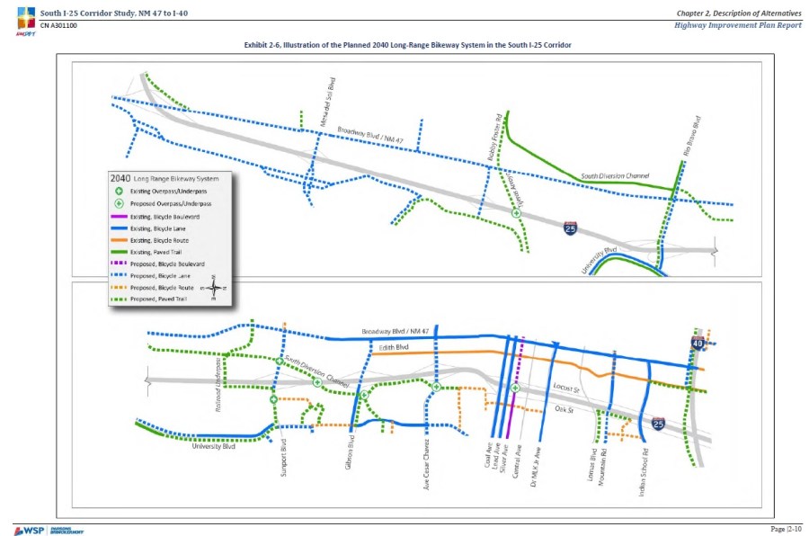
In the Study’s defense, it’s bicycle recommendations were made directly from the 2040 Long Range Bikeways Plan, and its map indicating plenty of improvements in the corridor, including a very much needed South Diversion Channel Trail, but no bike/ped bridges:
So, to make a long post end at least a tiny bit more quickly: What needs to be done?
- The upcoming 2045 edition of the Long Range Bikeways Plan needs to include bike/ped bridges, perhaps at Kathryn closer to downtown and San Jose Avenue a bit further south;
- In addition or instead, fully separated a bike facility could end in a fully separate bike/ped bridge at the new crossing at Woodward/Sunport;
- The I-25 South Corridor Study needs to be revised to reflect these changes; and, bringing us back to Lead Avenue.
- At least one, and preferably more, I-25 crossings along the south corridor must have no on/off-ramp access to I-25.
If Lead Avenue is really going to be part of Silver Bike Boulevard, that crossing needs to be disconnected from I-25, both southbound and, most pointedly, northbound.
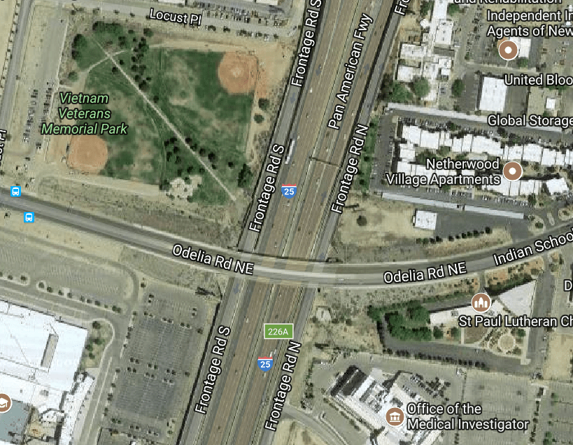
Otherwise, the safest Lead Ave. will ever get is equivalent to the situation at MLK and I-25 now, where we have a very nice bike lane facility torn asunder by a nasty I-25 crossing. The future of Lead at I-25 should not be MLK, but Indian School/Odelia, that rare crossing with no I-25 access.
And yes, I hear you saying/thinking: “But Scot, Lead is a vital downtown access road, while Odelia just dead-ends at Broadway.” True, but if the “fix” for Lead Avenue in the long-term future is to merely put a scrawny “cycle track” between frontage roads then it’s very, very clear we don’t know how to make such crossings safe.
So we shouldn’t have one involving cars exiting/entering the Interstate. At all.

[…] a vague graphic ICYMI from the Study illustrating, in red, this cycle […]
LikeLike