by Scot
So you’re cycling away on some of the wonderful bike infrastructure here in the Duke City, when, suddenly, you go from feeling all cozy and spice and everything nice, to staring immediate death in the face.
That is, you approach an intersection. Let’s say an intersection like this:
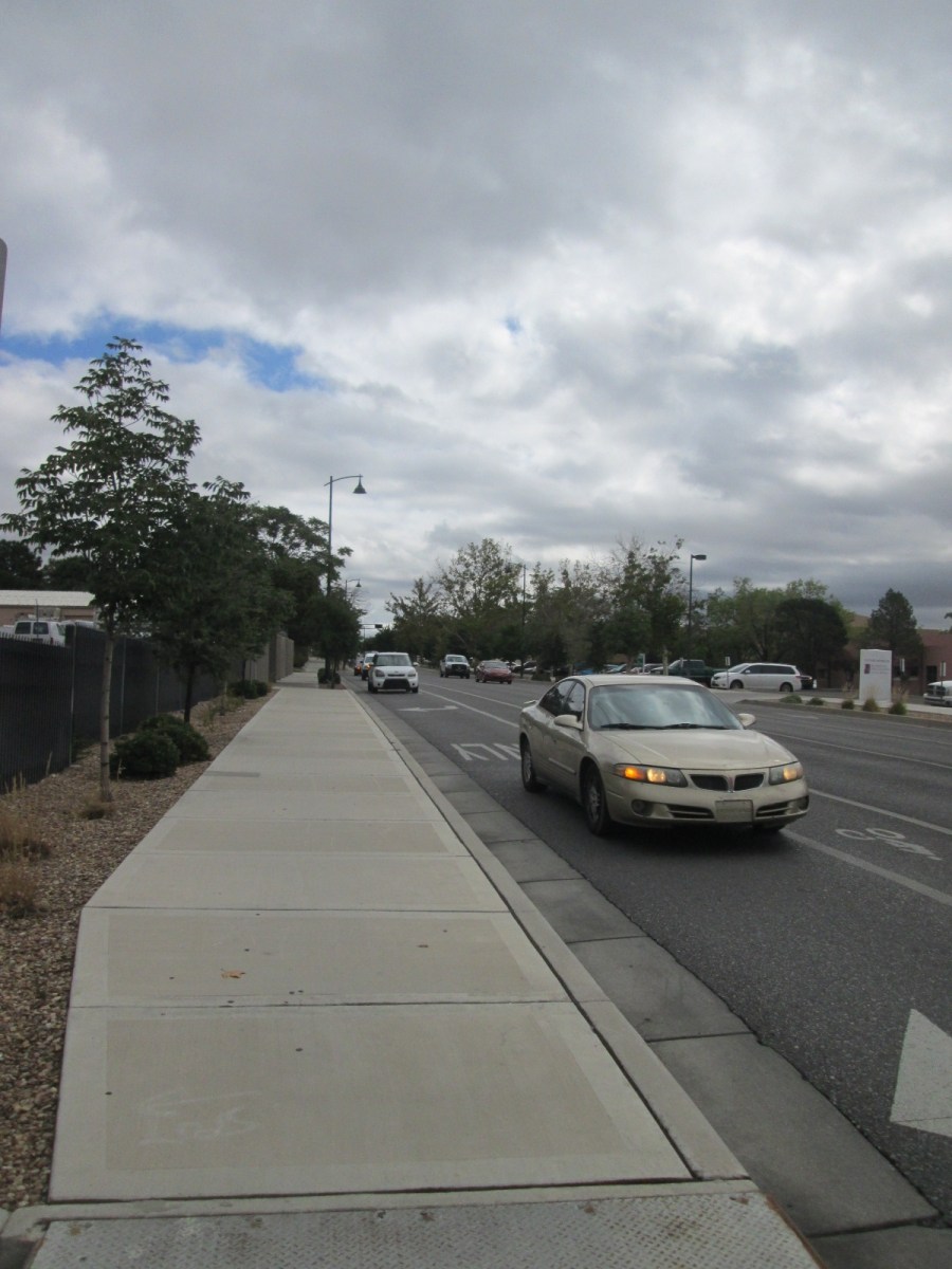
This is our good enemy, Lead Avenue at Oak (I-25) westbound. Whereas a few hundred feet up the road (it’s downhill, as you probably know) you were ensconced in relative safety, moving just about as fast as the cars, now you’re plunged into a ******* ************* mixing zone.
Drivers, deathly desperate to get on the Interstate to go home and play with their kids who they just got GI Joe’s “with the Kung Fu grip,” are hurtling across your, formerly precious, bike lane. In their haste, some drivers, like Pontiac driver guy here, unreasonably continue to use part of your bike lane. That’s so they can take the right turn at maximum speed (whatever that speed is for a kinda crappy looking Pontiac, no offense) and continue on their unsafe and merry way toward Kung Fu Grip experiences.
So how could we make this patently unsafe ******* mixing zone safe enough for cyclists, even, for lack of a less unfair term, “scaredy-cat cyclists”? I ask because we need to remember that not only is this stretch designated as bike “friendly” (i.e., bike map/bike lane), it’s part of the ******* Silver Bike Boulevard.
Lead and I-25, at present, ain’t no ******* bike boulevard.
Of course ******* mixing zones are everywhere, and civil engineers all over are trying to come up with meaningful and encompassing solutions to the problem. Here’s a recent attempt at Columbus and 70th Avenue in Manhattan, NYC:
 Photo: Streetsblog
Not identical to Lead/I-25, of course, but similarly forcing those turning from Lead to Oak to get on the Interstate would give more separation and sight time for drivers and cyclists. Yes, some drivers would probably end up flipping their car into what is the green light above, but, a bit of Darwinian driver behavior later, safer, slower, compliance might follow.
Meanwhile in Salt Lake City, engineers have crafted a protected intersection that may also have features useful at Lead & Oak. A modified version of the separation in NYC, SLC uses substantial curb in a modified “pork chop”:

Note as well above the use of curb-mounted flex posts leading to the intersection.
Would either of the two protected crossing designs above work at Lead & Oak? Well, that depends quite a bit on:
- What you mean by “work”
- How these design ideas are incorporated at a significantly dissimilar crossing.
Perhaps most important is the need for communication, an example being presentation of these and other examples as options to City of Albuquerque and New Mexico Department of Transportation (I-25) officials. Better Burque readers are encouraged, as always, to dream up (or in my case steal) improvement alternatives and contact City Councilors, ABQ Street Department (DMD) staff, NMDOT engineers (you might want to wait until we have a new governor for these contacts), etc.
While it might seem meaningless, and the current configuration would appear to prove this, the bike boulevard designation at Lead and I-25 can actually be quite powerful in moving toward a safer intersection at Lead & Oak.
I believe we’ve previously mentioned the 2016 I-25 South Corridor Study which, over 200 pages, outlines recommendations for a revamped I-25 all the way from I-40 to the Broadway/NM47 south of town. In those ~200 pages, the Study recommends ZERO, absolutely ZERO, improvements beyond bike lanes for any intersection crossing of I-25, EXCEPT for:
The Lead Avenue interchange will be improved to provide a westbound on-street bicycle lane, 10-foot sidewalks buffered on the south side by a landscape strip and by a cycle track on the north side. The cycle track provides connectivity of the Silver Avenue Bike Boulevard across I-25.
Here’s a vague graphic ICYMI from the Study illustrating, in red, this cycle track:
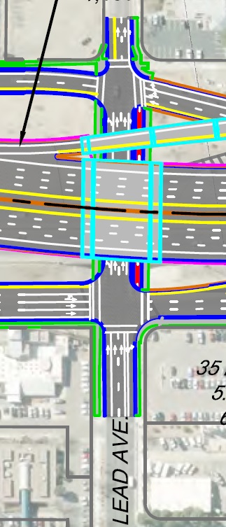
And this cycle track is recommended solely due to bike boulevard designation.
Now (said understanding that we’re years and years away from maybe getting the cycle track above) we just need to figure out how cyclists can get from Lead to that cycle track without getting killed in the ******* ************ mixing zone.
Ideas?
