
A long-time Albuquerque complaint made by myself and other non-motorized roadway users is that each and every quadrant in town has at least one bike/ped bridge over the Interstate, except the stretch of I-25 south of the Big-I.
But there was a time…
For years, I’ve had a personal fascination with Burque’s Lincoln Junior High, built in 1923 and closed in the early 1970s in a controversial swirl of race, busing, dilapidated conditions, pointed arguments over who let the conditions become so dilapidated, and de facto segregation. With an overwhelmingly black and brown student body from neighboring East Barelas, Martineztown/Santa Barbara, and east to Buena Vista SE north/south down to Kirtland Addition, Lincoln was a place of internal pride and external discrimination for decades.
Along with fascinating stories I’ve read, offline, over the years involving public protest by students and families at “White” Jefferson Junior High (now Jefferson Middle School) when former Lincoln students began matriculating there (protests which included lining up around Jefferson to threaten/block these students), I’ve also been interested in the story and outcome of Lincoln from a transportation angle.
Here’s an excerpt of a 1954 map of “West Albuquerque.”

And here’s pretty much the same excerpt from the 1960 map:

Notice any differences?
Yeah that “Under Constr.” thing is I-25. Most kids who attended East Barelas (aka South Broadway/East San Jose) schools (Eugene Field, John Marshall, and East San Jose) walked/rode bikes to Lincoln Jr. High up to 1960 because:
- The bus rules have always generally been that you had to walk/cycle or get your folks to take you to school if you lived less than 1.5 miles from the school; and,
- No Interstate Highway was in the way.
What was in the way was a pretty steep, sandy walk/ride route up part of the way from the Valley to “the Heights.” Here’s a description of that experience from a Albuquerque Tribune story of April, 1970:

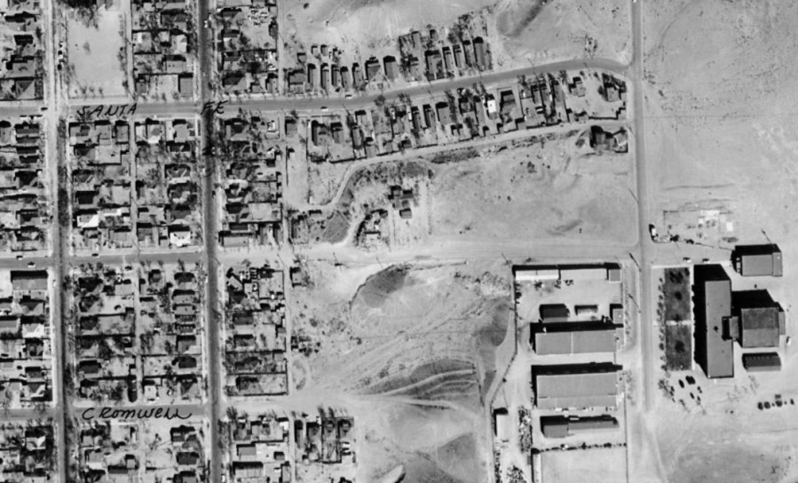
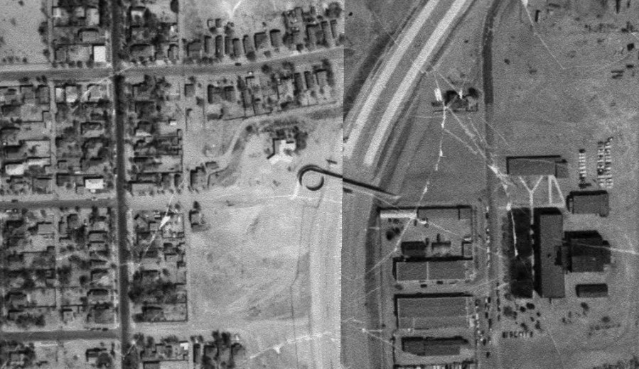
We’ve written a few BB pieces over the years about the “Border Wall” outcome of I-25 bifurcating neighborhoods and killing non-motorized connection for miles south from Lomas Blvd. Keeping Lincoln Junior High in mind, here is a 1959 aerial look just prior to construction:
And here’s the same look two years later:
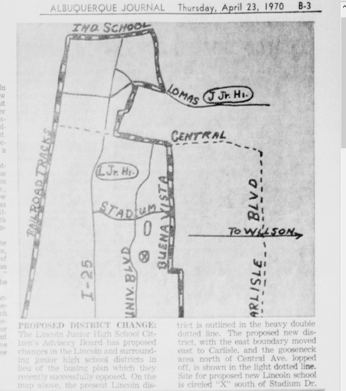
Which finally gets me to the mystery. In the course of newspaper research, I came across this singular reference in one of the many Journal/Tribune stories written during the 1970 closure brouhaha:

“…kids can only reach it by crossing the catwalk over the freeway…”
WHAT “CATWALK”!?!
Maybe you noticed a little something in that 1961 during I-25 construction aerial above. Let’s look at it again.

And let’s blow that up a bit:

What’s that horn instrument looking thing just south of where the two white lines o’ I-25 end?
I think it’s a “catwalk,” perhaps temporary at this time, running from the sand at the end of Pacific Ave. (one block south of Santa Fe Ave.) up and across the leveled to-be-I-25 over to Lincoln. Let’s look at the wider photo one more time:
I don’t know when this or any following semi-permanent “catwalk” was removed. And no, I’m not 100% sure that’s the catwalk. Long, long story, but maps and aerial photos have a strange gap between about 1960 and 1990, at least via my online sources (linked above). USGS maps during this gap use the 1960 map, putting anything new (roads, subdivisions, etc.) in reddish-purple through a series of updates extending to 1985. Available aerial maps through the handy-dandy CABQ Historical Aerial Viewer cut off in 1961 until 1996.
Hence the only map verification that such a catwalk existed is an extremely faint line segment with end flares (I’m sure that’s not the name for such things) crossing I-25 in later updates of the 1960 USGS (here 1974):

That’s it. That’s the “proof” there was once a bike/ped bridge, of sorts, in the Interstate quadrant of I-25 south of the Big-I.
Integral to my “Catwalk Mystery” has been a lack of complete data. Which, to be honest, makes such mysteries more fun. It would also be GREAT fun to hear from anyone still around who walked that catwalk to/from Lincoln Junior High and/or remembers it hanging, precariously in my imagining, above and across the roaring Interstate. My guess is there are plenty of folks who remember.
If you’re one of them, drop me a line in some manner circa-2020. Much appreciated.

Well done! Thanks. These details put flesh on the Skeleton story of Albuquerque. Reference to Model Cities should attract some attention.
LikeLike
[…] wrote last week about the closure of Albuquerque Lincoln Junior High back in the 1970s. It’s so very tempting to post about 73 follow-ups to that closure, and I’m serious when […]
LikeLike
Yep! I attended Lincoln from 69 to 72 and walked that catwalk twice a day every school day. I remember it well! Some kids would drop pebbles onto the freeway below. I remember one day, I think it was a Monday, someone had written something in the concrete sidewalk of the catwalk that was derogatory to blacks. There was a big ‘ol stink over that! Lincoln was about 50% black, 40% hispanic, and 10% white.
LikeLiked by 1 person
I remember the catwalk well
My brother went to that school and the rest of us kids went to Eugene elementary school
My family lived at the of Santa Fe street
We played on that catwalk all the time.
LikeLike
It’s crazy the line house that was separated from the rest of the neighborhood is still there. It has been remodeled and built onto. It’s some sort of plumbing company live/work deal by the appearance.
LikeLike
The lone house*
LikeLike
I still remain true to my home on Santa Fe Ave SE! Built in 1938 and my family moved here in the 1940’s. Me and all of my brothers and sisters went to Lincoln Jr. High, home of the Dusters! The beautiful Catwalk was demolished in the early 90’s I believe. All the others in town were upgraded and ours never got rebuilt because they said that Lincoln was no longer a school. No access to Roosevelt Park, Milne Stadium, APS Complex jobs 😡
LikeLike
I attended Lincoln Junior High from 1959 to 1962 and remember crossing the overpass. Before it as open we walked under the Interstate through the arroyo tube the went under the Interstate. Many memories of walks home the East San Jose Elementary School area.
LikeLike
By the way, the Lincoln Junior High School Mascot was the “Dusters” named after the Sand Dusters that cropped up during windy days.
LikeLike