
Almost nobody these days asks me for suggestions on where to safely ride bicycles, which is a shame, as I’m more than happy to share way too much information on the subject. It’s also a bit of a shame nobody blogs or reads blogs anymore, as I have a bit of research/homework that could use your help, if you, Albuquerque bicycle rider who reads this blog, existed.
Perhaps you do exist. Is there anybody out there?
Now that you’re here and are asking (thanks for asking), I do have a long set of streets, not roads, not “stroads,” not “arterials” in our fair city that are (to wit: The Four Criteria for a Real Bike Route (FCRBR):
- Nearly devoid of car, big-ass truck traffic at all times.
- Close to your house or somebody’s house (look ma, no need to drive the bike long distances to get to the “safe” bits).
- Actually useful for getting from Point A to B.
- Safe enough for all riders, ages 8-80 (and beyond).
In perhaps sensing your presence reading the above, I also sense a “no way” or “are you kidding..in ABQ?” reaction to the above. It’s understandable. Both the perception and reality is that cycling ABQ streets is so dangerous folks drive their bike miles and miles to get to the bosque. I see them unloading those bikes at, for instance, where Marquez turns to Tingley Dr. often, especially on a nice day.
But these safe (or at least massively safer than the norm here) streets ARE out there, and you’re gonna help me identify them as we, together, put together a map that kinda looks like this (but is way better):

Yeah, the above (and link) is the interactive, ABQ Bike Map from the City. Brown is “Bike Route,” blue is “Bike Lane,” etc. Maybe you’re used this map in the past. I kinda wonder if you’ve used it. I don’t think many folks actually do, but I could be wrong, because, in large part, we don’t collect data on how many folks use this map or pretty much anything else related to cycling ’round these parts.
We’re gonna change that, you and me.
Let’s focus on the dirty brown line segments above, the dirty, lowly, and often ridiculed Albuquerque “Bike Route.” The “system” (in perhaps the single worst application of that word, ever) of Burque bike route designation has haphazardly developed over decades, with some more recent decades largely missing. If you “interact” with the link, or even stare at the image above, you’ll notice some parts of town with truly robust dirty brown and others with almost nothing (e.g., the NE Heights). Adding the fact that there are many dirty brown line segments that in absolutely no way should be considered “bike routes,” such as 2nd N.W. from Downtown north past I-40, we’re left with the common knowledge that use of bike route (and bike route signs) is a worthless, perhaps even deadly dangerous endeavor.
We’re gonna change that, you and me.
So here’s the actual three-part homework assignment:
- Identify and map safer streets meeting the criteria outlined above;
- Dive into the existing “system” of bike routes and cull the dangerous ones
- Put together a new map combining the safer old and new streets and show/tell everybody about it.
To get the ball rolling, here’s a candidate set of safer streets connected on the far West Side currently not designated bike routes (many of these will be on the West Side..it’s a bike route desert):
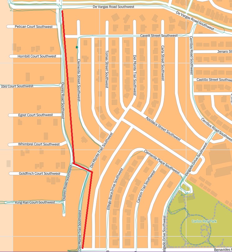
Where the hell is Osprey SW? I know, I know, you’ve never been there, but, believe it or not, a bunch of folks (a ton) actually LIVE on/near Osprey SW, and Del Monte Trail SW, and Rio Puerco Trail SW, and Delgado SW, stretching all the way north/south from DeVargas SW (where’s that?) to Gibson Blvd. (there’s a Gibson Blvd. on the West Side?).
No, really these streets exist and the people living on/near them exist and they currently live in a bike route desert, despite the fact this is the fastest-growing part of town (again) and many of them are moving from out-of-town and might like to know where’s it’s safer to ride a bike near their house:

In the case of this set of streets, your humble blogger has ridden them numerous times (note little squiggly green lines on the brown map with red line segments above) and found them fitting all Four Criteria for a Real Bike Route (again, FCRBR, learn the acronyms, people). Don’t believe me, go out there and ride them yourself. You might say in response that: A. Those streets are 94 miles from my house, and/or B. There’s no safe cycling connectivity from where I live to that place 94 miles from my house.
And you’ve identified two big reasons why we’re doing this homework project. For one thing, we need to stop being so self-centered. There ARE other parts of town beyond where we live/ride. And for another thing, these folks living on/near Osprey SW need better bicycle infrastructure like bike route signs connecting them through their neighborhood, even if many/almost all of them don’t seem to currently need or want it.
Because bike routes and bike route signage do matter. That’s a/the major assumption of this homework project. We, if you exist, are not only making this assumption but undertaking a bunch of bike rides, map staring, and thinking based on this assumption. Pass along your candidates through the usual channels, including an email to betterburque@gmail.com (because the comment system on WordPress sucks). Hint: Look on the West Side, west of Coors. Also, pass along your candidates for “Deadly Existing Bike Routes that Should Never Have Been Designated Bike Routes” (okay, that would make too long an acronym). Your humble blogger will compile and put together a map combining the good and eliminating the Deadly.
C’mon…it’ll be fun. Hell, there are bike rides involved.

Arrived in Albuquerque this weekend. Count me in! ________________________________
LikeLiked by 1 person
Does Rio Grande count? It’s got dedicated bike lanes both sides of the street for long stretches. The Rio Grande and Central intersection is a bit of a disaster, so I guess have people cut through old town or something? The main problem with it is the actual bosque trail isn’t that much further west, so why wouldn’t you just choose to ride there instead. Maybe try emailing this post to Peter at Downtown Albuquerque news and he might link to it, or have ideas himself!
LikeLiked by 1 person
Rashad: On one level, Rio Grande Blvd. counts if you think it counts. It also brings up a good case of a popular bike roadway that some feel almost perfectly safe riding and others avoid (taking Bosque Path/Riverside Trail/Paseo del Bosque/whatever you call it, instead). I guess that’s true for so many roads. Maybe it would be useful to require something like a 90/10 rule, namely 90% of those who ride a bike at least once a year must think it’s safe/comfortable before it “counts.”
With that criteria, Rio Grande Blvd. probably doesn’t make the cut, does it? Not even the slow curvy part past Dietz Farm. I could be wrong, though. Who’s up for some rider, potential rider surveys?
LikeLike