
The City is putting together its next iteration of the “Bikeways & Trails Facilities Plan,” which was a 312-page behemoth in its last edition back in 2015, copies of which are now standing, never read and almost never referred to, on bookshelves of scattered bureaucrats and cycling nerds (your humble blogger raises hand sheepishly).
Planning to write a plan meetings are currently underway and the conceptual frame of this iteration centers on study and establishing of a “low-stress network.” I’ll skip most details of what is meant by “low-stress network” in this post because, well, because most of you reading this already know about it and also have that 2015 312-page behemoth stuck somewhere on your bookshelf. So let’s skip ahead and talk “LTS 1/2” or roads/trails considered safe/comfortable enough for “Interested, But Concerned” (IBC) riders to use with traffic volumes, say, <10,000 daily and with wide and/or paint-“buffered” bike lanes.
Yeah, definitely writing for an audience of about five this morning…
Anyway, to further speed things up, let’s just jump to an example: Rio Grande Blvd. north of I-40 extending to Alameda Blvd. Rio Grande is currently mapped out in these planning to write plan meetings (your humble blogger attends) as LTS 2 from a bit north of Indian School to its northern terminus just north of Alameda. You know, the stretch with the wider bike lanes, “buffered” for quite a stretch, and the 25 mph speed limit through Los Ranchos.
Sure, you know about it because you ride it. You being one of the five people reading this blogpost. Question is (actually brought up indirectly by a reader recently): Is Rio Grande between Indian School and Alameda safe/comfortable enough for IBC cyclists? Of course, “we” ride this stretch, some of us regularly, but do “they” ride it? I’m honestly asking, as my sense, but only my sense, is that a few in the large group of IBC do, but not many.
I could be wrong about that, particularly on weekends, and I’d like to get feedback from all five of you on the issue. But more to today’s “point” as it were, let’s talk about connectivity and what is most definitley NOT a LTS 2 stretch of Rio Grande Blvd. Specifically, the anything but safe/comfortable stretch of Rio Grande from a bit north of Indian School south to Central Ave.
To further consideration of this stretch beyond our own, sometime/often/always hair-raising experiences attempting to ride it, let’s look at some Strava Heatmap.
You, like many of us, live south of I-40. You want to get to the “good” part of Rio Grande Blvd. north of Indian School but not die before you get there. What do you do?
Interesting aside: This and similar routing/logistics questions/discussions always never, EVER come up in ANY meeting or formal discussion of “bikeways.” Like NEVER.
I’m very truly interested in your answer to this question, yet I think I kinda already have the answer, thanks and illustrated by the Strava Heatmap.

Guessing all five of you have already spent time staring at the Heatmap for one reason or another over the years, and bouncing between the easy to spot street names in the “without heat” image and the “with heat” image, can you spot the popular route (among only Strava subscribers and only their “for everyone/public” rides, admittedly) that avoids Rio Grande from Mountain north to just north of Indian School?
I further guess that most/all of you don’t even look at the maps, because you know. You just know.
Interesting aside 2: Discussions about how cyclists come to know about such routes and how that information is passed from one cyclist to another NEVER comes up at ANY such meeting.
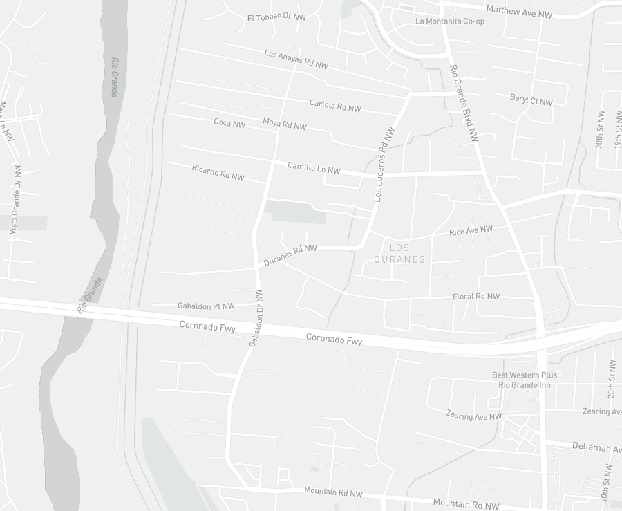
But just to get us all on the same page, so to speak, your humble blogger and evidently at least a few other cyclists:
- Head west down Mountain (specifically only after making a squiggy north west of Rio Grande because Mountain just west of Rio Grande sucks)
- Go north on Gabaldon under I-40
- Either catch Duranes and go NE as it changes to Los Luceros or just take Gabaldon further north to Los Anayas
- Catch Los Anayas east to the safer/more comfortable part of Rio Grande Blvd.
Yes, that’s what “we” do, understanding that far, far more cyclists just take the Bosque Path and never take Rio Grande, with a few of them catching up with us by only getting off the Path further north and going through Thomas Village (using Don Quixote NW shown as “pretty warm” above). Yeah, you five probably know about that one, too. How’d you find out?
So this is what some cyclists are doing, understanding that Strava Heatmap has data collection shortcomings but also understanding that we probably shouldn’t just throw the Heatmap out altogether as a LTS 1/2 cycling network construction tool. So what do we do with this information in terms of putting together a LTS 1/2 network with actual connectivity?
I propose we just incorporate what cyclists are already doing, largely with zero “bike infrastructure” improvements…
Interesting Aside 3: I find it funny that the absolute worst stretch, by far, in our route outlined above is Mountain Rd. between Rio Grande and Montoya, a designated “Bike Boulevard.”
This focus on what folks are actually doing, as opposed to the mindset that if we “improve” things they will come is pretty antithetical to the whole “Bikeways & Trails Facilities Plan” concept. And I must admit that’s a big reason I like the idea so much; however, it’s also a good idea. Because, for one thing, approximately how many of the countless “improvement” projects required to formalize cycling network connectivity citywide are actually EVER going to be completed?
1%? 5%? I think any of you five readers suggesting 5% are endearingly optimistic. And also wrong.
Incorporating little “tricks” like Gabaldon Rd., through tools such as Strava Heatmap and, perhaps, hyperlocal survey research asking cycling neighbors for their neighborhood local knowledge are realistic (i.e., extremely cheap and non-driver behavior threatening) and vital components in putting together a truly connected LTS 1/2 bike network in Albuquerque.
What do you five think?

I was thinking about this today as I avoided the stretch of Mountain to which you refer that the rest of Mountain, east of there, is not at all low stress despite being a bike boulevard. But, thanks to your Low Stress Network evangelizing, every time I got on a side street that had speed humps I felt less stress. Maybe presence/absence of speed humps as a criteria? Because it means a) the street goes somewhere, and b) drivers have to slow down and pay attention.
LikeLiked by 1 person
Anon: Interesting to consider how different cycling is 2023 versus, say, 2005. Bigger tires, more suspension, riding slower (we’re all riding slower now, right?) = speed bumps good, no longer speed bumps bad. Unfortunately, methinks the bike “network” is still largely based on cycling 2005.
LikeLike
[…] the community and its gummint entities seek to develop a low-stress cycling network, the importance of bollards and their driver-thwarting relatives in designing such a network will […]
LikeLike