
Two posts in one day. Better Burque might need to slow down or hire new unpaid staffers…
All this talk, study, and writing about the I-25 S-Curve might be prompting the same question raised by a reader earlier today: Why was an “s-curve” created in routing I-25 in the first place? Well, here’s why according to a story in the May 24, 1956 Albuquerque Journal:
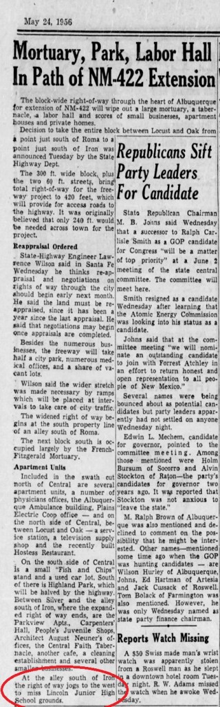
So it was all about now long-long closed Lincoln Junior High!
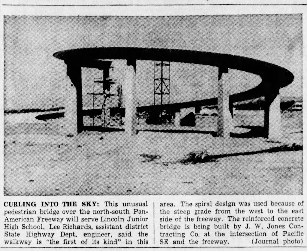
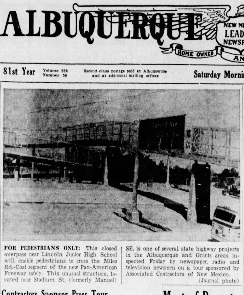
Speaking of Lincoln, long-time BB readers might recall a piece about a mysterious “catwalk” to/from that school “newly discovered” by your humble blogger through a look at historical aerial maps. Well, the catwalk was mysterious to me largely because I wasn’t using the right search terms at Newspapers.com. The structure was actually first-page photo news more than once around the time of construction.
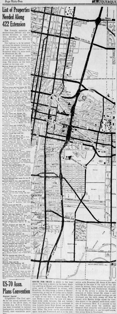
So, all this S-Curve study and current brouhaha apparentely stems from location of a school that closed fifty years ago, in the mid-1970s (in another long story worth reading about). In addition to the Lincoln research goldmine above, I found a really cool Journal story/image from June 3, 1956 outlining the I-25 route from Menaul south AND the list of properties to be destroyed purchased through eminent domain. Below is the blurry version (thanks, WordPress!); email me at betterburque@gmail.com if you’d like to see the unblurry original.

Thanks. Great stuff.
That list of properties “to go” was really something.
My wife and I live at the corner of Edith And Garfield…this has been of real concern.
Don’t overwork that future unpaid staffer…unless you’ve already hired him…which I think you have.
LikeLike
Scott, Thanks…not sure if my subscription went through. This is a great website, especially in light of what is in the works for I25’s infamous S-curve. I appreciate the circling of the paragraph about Lincoln Junior High. But does it state specifically that that is the reason for the S-curve in the first place? Sorry…my US Army interrogator training at work here. In the flyer passed out at the meeting on 12/3/2024 the text stated “No documentation could be found…”. This in spite of the presenters having stated at an earlier meeting (November 2023) that avoiding the school was the reason. I did an AI generated search and it came up blank as well…but all that means is that the relevant documents might not be available online. You do killer research. Great work. Tony
LikeLike
Tony: Admittedly, the word “apparently” was doing pretty heavy work in that sentence regarding whether this constitutes total proof that it was about avoiding Lincoln, but that newspaper reference plus a look at the map/route where I-25 plunges straight as a board before skipping west also “apparently” looks convincing. I’d always had the overall hunch it was about avoiding the APS land grant boundary altogether, Lincoln included, and will get around to some more digging with that thought in mind as well. – Scot
LikeLike
You know…that comment from the state highway engineer is very interesting. I think it is an implication of what truly happened.
The land belonging to APS had to be reappraised before construction could begin. 2. The state agreed. 3. The new appraisal came back at a higher value. 4. APS demanded the new value as payment. 5. The state refused and decided it would be cheaper to pull “eminent domain” on the homes/businesses that were eventually cleared out.
This is in light of the fact that no documentation could be found suggesting that the reason for the curve was to avoid putting children in danger. Which they would not have been because barriers would have been put up. Hayes Middle School “looms” above I-40. There does not seem to have been much fear re: that MS and a major Interstate.
Of course, this is speculation on my part.
LikeLiked by 1 person
Good catch, Tony, and I’m with you on the speculation. About Hayes MS, it was built in 1963 to conform with the “Coronado Expressway” (I-40). I’d attach a screenshot taken from the 1961 ABQ Historical Aerial Map, but this is WordPress (i.e., I can’t). The link gets one there after some clicking of buttons and such.
LikeLike
I-40 did not exist in that stretch of Albuquerque, did it? In 1963?
LikeLike
Just read that the “Coronado Freeway” (the name for I-40 as it moves through Albuquerque) was completed in 1962.
Hayes MS was built in 1963.
Not much concern for the safety of students, apparently.
LikeLike
Scott,
That above comment was from me (Tony). Sorry for any confusion.
LikeLike