
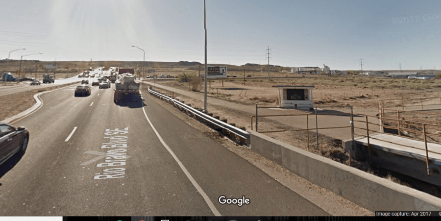
The northern terminus of the South Diversion Channel Trail at Rio Bravo is currently a very unfriendly place.
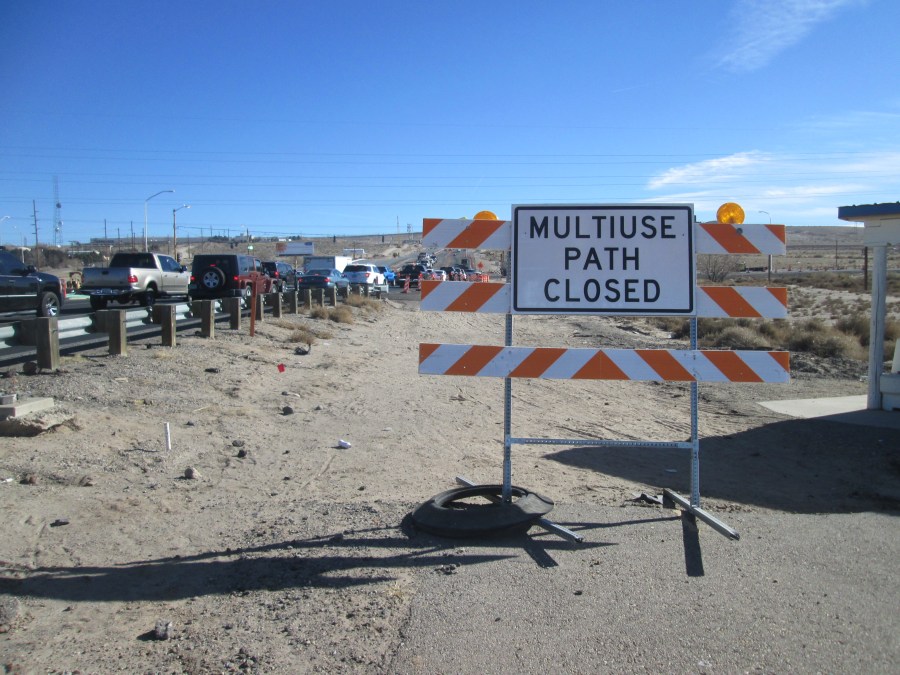
As the sign, and lack of previous pavement, indicates, there’s no longer a little spur to Broadway/NM-47 from the terminus. Meanwhile, vehicles are backed up day and night due to the Rio Bravo/I-25 Interchange construction project. Trash and jagged blocks of concrete are everywhere.
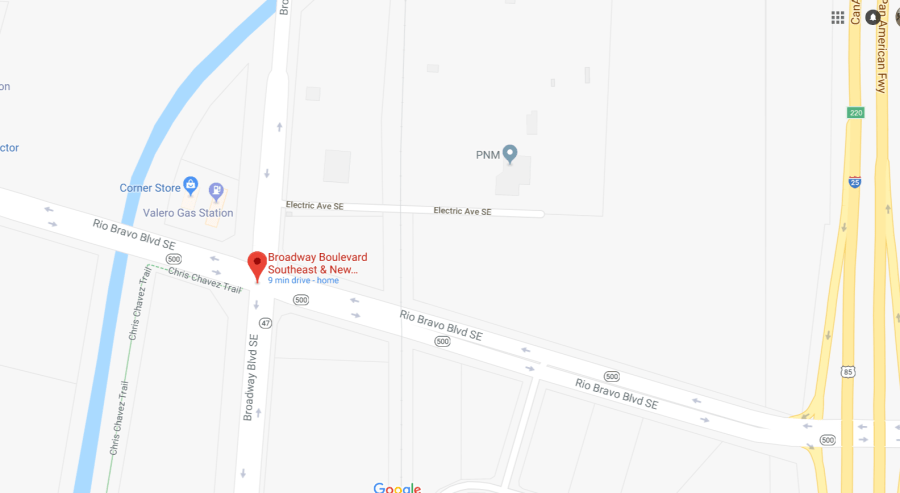
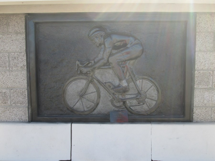
Here’s a map, in case you don’t make it down this far south much. Note the trail alongside the South Diversion Channel here is the “Chris Chavez Trail.” Mr. Chavez was a fire fighter killed riding his bicycle to work back in 1999. In 2000, a bas relief sculpture memorial to Mr. Chavez, entitled “Spinning” was placed at this currently unfriendly spot:
Unlike its partner, the North Diversion Channel, the South Diversion Channel is only multi-use trail for a short while, looping north from Tijeras Arroyo about a mile or so south. Here’s the approach to the northern terminus:
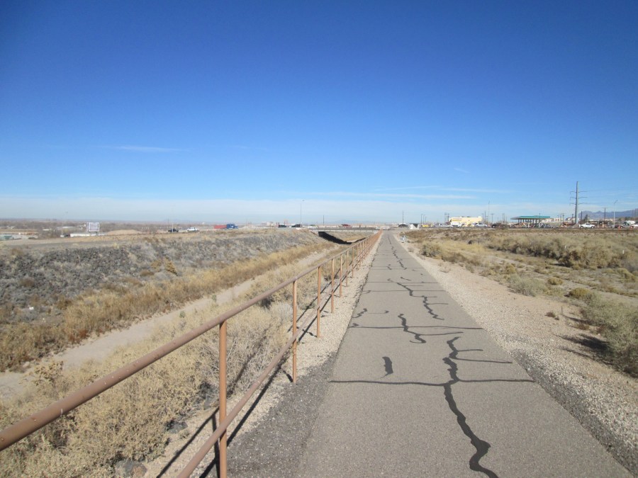
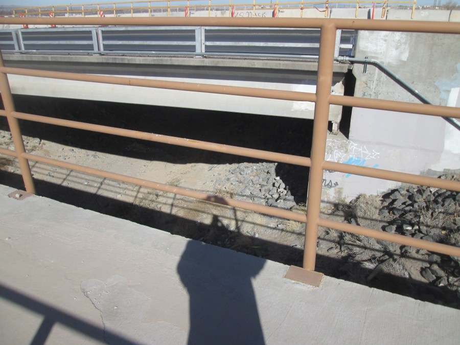
And here’s a view of the Channel as it goes underneath what appears to be a pretty old bridge at Rio Bravo:
You might have noticed above from the Google Map that this terminus is pretty close (“about 9 minutes”) to my house. I’ve bicycled a bit over 4,000 miles this year, many of those getting from the South Valley to/from “town,” but two rides I very rarely take are:
- The Chris Chavez Trail
- Anywhere in the far Southeastern Part of Albuquerque (e.g., the Airport)
The reason is pretty simple:

Above is where the continuation of the Chris Chavez/South Diversion Channel Trail should be. Well, technically it should go under busy Rio Bravo Blvd. and head north before, importantly, veering east under Broadway/NM-47 and Interstate 25. And because this Trail just stops at this unfriendly spot, I don’t ride it much.
Here is an excerpt from the 2040 Long Range Bicycle Roadway Map:
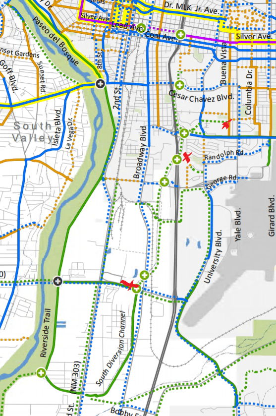
I’ve placed some crude x’s along the green dashed line indicating planned expansion of bike trail. The “x” furthest south is the current northern terminus. The middle “x” is where the actual Channel goes under I-25. The top “x” is just one of many possible termini for future extension, this one at University Boulevard, a road scheduled for major multi-modal improvements in the near-to-medium term.
Of course, you see tons of dashed green lines running all over the place on the 2040 Long Range Roadway Map. Potential expansion of bike facilities, in this case multi-use paths, is scheduled, long-term, everywhere, particularly in this far southern part of town.
But here are a few reasons why extending South Diversion Channel Trail further north, and east, must be at the top of any list dedicated to prioritizing which of the many dashed green lines above become reality:
- While Rio Bravo/I-25 interchange, and the (perhaps) eventual Sunport extension, will have cycling/walking improvements, the fact is very few non-vehicular cyclists/walkers (i.e., the huge preponderance) will walk/ride the steep grade to/from I-25. Ever.
- Going under/over I-25, or any interstate highway, via roadways shared directly with cars will never attract the sufficient numbers of roadway cyclists to significantly grow ridership here. Extending South Diversion Channel Trail under I-25 will offer the same safety comforts found at its northern partner, the North Diversion Channel Trail.
- Why does the northern half of Albuquerque get nice things while the southern half doesn’t?
- To be honest, not extending South Diversion Channel Trail seems a bit disrespectful to Chris Chavez, the subject of the bas relief memorial pictured above. Apologies for not taking a current photo showing the area around this sculpture/memorial, but even back when the little spur to Broadway did run next to the memorial, the scene, sculpture aside, was anything but pretty:
Thus, Better Burque has made extending South Diversion Channel/Chris Chavez Trail north its 2018 New Year’s Resolution. Three things to keep in mind:
- Unlike almost all such resolutions, we’re keeping this one;
- This is a project that might require it also being our 2019 and 2020 resolution. It’s going to take some time.
- It’s not going to happen without your help. And by “you,” we mean many people from many positions/constituencies of the community. Certain City/County public officials: We need you. Walking and cycling advocates: We gotta have ya. City/County/AMAFCA bureaucrats (and we use that word very, very lovingly): You are, as always, absolutely essential.
So let’s get to work. And let’s not have this resolution end up like 99.9% of Scot’s involving losing weight and slowing down on the beer. This one really needs to happen. This one will happen.

Thank you for this incredibly informed post! My wife and I ride this area often, usually 2 times/week. The southern portion of the Bosque trail, as it loops west and then north is among the best cycling routes in the city. Biking for miles on the wide trail, under a tree-covered canopy, is an incredible experience. The downside? Getting to this trail!
Our usual route has been University avenue south (which is actually a very good bike trail; about 2/3 of this is on a dedicated bike path), followed by the mad dash down the hill on Rio Bravo to Broadway. This half-mile dash is nuts, right in the middle of traffic, especially as you cross under I-25 and find merging traffic on BOTH sides of you. Yes, it’s unsafe, and the construction on Rio Bravo has made it so much worse. The portion near the stoplight with Broadway is also crazy, with a terrible choice between getting in the left hand turn lane at Broadway or staying right, crossing Broadway, and then crossing Rio Bravo with the crosswalk signal.
One of the biggest issues here is the left turn signal (on westbound-Rio Bravo) which turns green AFTER the through-portion of the light. As a result, you’re stuck in this one-lane turn bay, while traffic whizzes by at 55+mph on both sides, and the wait is LONG, roughly 2 minutes. If this left hand turn went first, you could clear this intersection on your bike and make it to the trail on the southwest side of the intersection. So, a simple change of timing at this light would help tremendously as a short-term fix.
In the longer term, extension of the South Diversion Channel trail north, under Rio Bravo and I-25, would be fantastic, and eliminate the incredibly dangerous portion of this otherwise magnificent ride.
Thanks for the detailed discussion, and if you might, who would be best to contact to show our support for these changes? We’re happy to contact City Council, Planning, or advocate in other ways which might help.
Joe Martz (and Jackie Smith)
LikeLike
[…] we can’t give up on Better Burque’s Resolution for 2018, extending the South Diversion Channel (SDC) Trail north from Rio Bravo near Broadway all the way […]
LikeLike
[…] The charmingly chairless GABAC will talk Vision Zero, the late, deeply lamented Fourth Street Protected Bike Lane (PBL, yes, we really call ’em “PBL”s, we are sorry, we also sometimes use the word “signage”), and the dreamy possibility of a South Diversion channel trail. […]
LikeLike
[…] safer for those walking and cycling our roadways, and, as just one specific example, think the South Diversion Channel multi-use path should definitely be extended north from Rio Bravo to CNM and […]
LikeLike
I rode this on Sunday. Meaning I rode the dotted green line. It actually wouldn’t take much to get this paved and usable, with the glaring exception of the Rio bravo and I25 underpasses. The rest is almost all old pavement on a decent roadbed. Broadway here is so low traffic, you would just need some minimal treatment. Dont have to go crazy with separation. Putting my bike on my back and running across Rio bravo wasn’t fun though. Definitely under. The Colvert under i25 is lovely this time of year. Not sure what it would take to make it real for bikes and peds.
But beautiful views, super easy grade, you climb out into a neighborhood that is nice, and an easy climb to university by the community centre and park.
There is actually another really nice memorial at the wash right before the gravel yard. Something like Pete’s Inlet, but it wasn’t Pete. Really nice artistic rusted iron sign. Should have snapped a pic. Would love to know the story behind that death in 2010.
LikeLike
With small caveat that Broadway traffic is relatively light, yet traveling as fast as Hell, completely agreed on how this can be done. BB has gotten distracted by so many transpo shiny objects (i.e., horribly unsafe aspects) that it’s good to hear back about South Diversion. We need, esp. in the SV, to not let this project get lost.
LikeLike
Yeah, Sunday afternoon probably was not representative either, and would be great to have something fancy there. If you had to cut, that’s where I’d cheap out, is all.
LikeLike
[…] that “South Diversion Channel be extended as a multi-use path to CNM” before realizing, minutes later, that this crazy person was […]
LikeLike
[…] Yes, these notches at east/west crossings cost money. So what? Future I-25 improvements, both North and South of the Big-I, MUST include funding for any and all walk/bike crossings, including NDC and, I would argue South Diversion Channel Trail. […]
LikeLike