by Scot
One of my roadway fixations the past few years has been the socio-economic and other impacts resulting from the route chosen for I-25 back in the 1950s, in particular from what is now I-40 to Rio Bravo. I have perhaps devoted more total words and pictures to this subject, one I term creation of a “border wall,” here at BB than anything other than pedestrian fatalities. Namely, you can read about it here, here, here, here, here and here.
One thing I had yet to explore was the 1950s debate over the route. My soon-to-be-permanent “newspapers.com” subscription (not shilling, but it’s proving to be damn good once you figure out the advanced search feature) has allowed me, and now you, to go back to the year 1956.
For it was that year in which the proposed route for “NM-422,” later named I-25, was designed by NM State highway engineering and voted upon by the State Highway Commission, after some extensive, yet still effectively limited debate on the subject. I say the debate was extensive, in that there were some public meetings and plenty of articles in the Albuquerque papers (yes, both of them) about it.
The existent limitations found in a review of Albuquerque Journal stories (sorry, but newspapers.com doesn’t have Albuquerque Tribune) from the period are that the debate was completely dominated by:
- State Highway Engineering (note lack of County/City control)
- “Respected” entities like the Albuquerque Chamber of Commerce and other “civic leaders”
- Former Governor, Mayor and all around dynamo Clyde Tingley (leader of the opposition)
- Business owners immediately upon and near the chosen route, such as French’s Mortuary and Presbyterian Hospital
- The Carpenters’ Union, a gas station and the relatively few home owners directly in the path of the chosen route.
In other words, there was no talk of the neighborhood impact, what is now called “community cohesion” in formal environmental assessments for new roadway construction, and what it would mean for folks living on either side of what became this “border wall.” It is certainly not a coincidence that the neighborhoods bifurcated by the route were, and continue to be, predominantly poorer Hispanics and the city’s largest concentration of African-Americans, and that their voices aren’t heard/read in the NM-422 debate.
No, that’s not a coincidence.
As happens with just about all discussions of complicated matters involving things like long-term socio-economic impact and what is now known as “community cohesion,” debate devolved into overly simplistic terms employed by those on either side. In this case, the massive implications of dividing near downtown neighborhoods in two was hyper-simplified into whether the route would be through the “heart” of the city.
Because hearts split in two are broken hearts. And broken hearts are, uh, bad. No, I am not exaggerating the level of political simplification.
In response to the “breaking hearts” argument, those in favor of the route chose another overly simple anatomical analogy. As stated in a resolution signed by the Albuquerque Junior Chamber of Commerce (yeah, that was a thing in 1956) with excerpts printed in long quotes by the Albuquerque Journal on June 14, 1956 in a story headlined “Highway Agency OK’s Proposed 422 Route After Protest Hearing,” the Junior Chamber of Commerce resolved that:
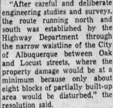
See Albuquerque? The route of future I-25 isn’t through the heart, it’s through “the narrow waistline of the City.” And waistlines have belts. And what would become I-25 is simply a…
You get the idea.
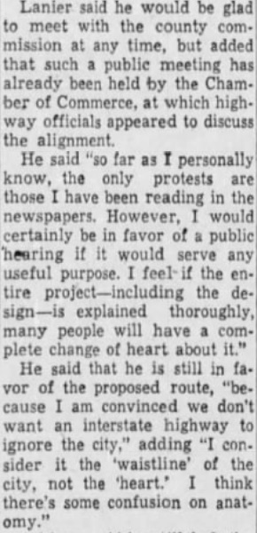
In building the “narrow waistline” “frame” (as marketers and storytellers call it), State Highway Commissioner Charles Lanier, very much in favor of the project, considered the debate a “confusion on anatomy.”
The result of this “framing,” and very much the relative political power of the voices heard in the debate versus those not heard, was approval of the route splitting what is now called “EDO” apart from Huning Highland, and the South Broadway, San Jose, and adjoining neighborhoods such as Kirtland Addition.
For example, no more walking 200 yards to Presbyterian Hospital to visit a friend if you live at Silver and High Streets. A leisurely stroll to Roosevelt Park if you live at Hazeldine and Elm becomes a death-defying gauntlet. Same for those living living east of I-25 as well, of course. What would it be like, for example, to live at Cedar and Coal and walk to the Albuquerque Press Club? Frankly, today that would be considered unthinkable by just about any sane human being.
One other wrinkle, curve ball if you will, in the NM-422 routing was what became the infamous, dangerous curve in I-25 between Coal Avenue and what is now Avenida Cesar Chavez. The argument back in 1956 was that the curve was necessary because going straight would impact Lincoln Junior High, an older school set in the middle of the large APS-owned land granted way back at the turn of the 19th Century.
So the infamous curve was chosen. In epilogue, Lincoln Junior High closed in 1974, after first being proposed for closure years earlier. The closure of Lincoln was hotly debated, with racial matters involved, as Lincoln had an almost exclusively Hispanic and African-American student body. At the time, nearby Jefferson and Wilson Junior High were predominately White. I’ll leave it at that for now, as we’re talking roadways, but the story of Lincoln Junior High is another interesting, and frankly somewhat embarrassing, episode in Albuquerque history.
“Confusion of anatomy” Charles Lanier, State Highway Commissioner, May 29, 1956
“Narrow Waistline” resolution of the ABQ Junior Chamber of Commerce (where a public meeting was held)
concerns of those whose properties would be taken for ROW, businesses nearby “French Mortuary, the hospitals, a gas station, the Carpenters Union, but no mention of what is now called “community cohesion” of neighborhoods split in two. Also, the infamous curve between Coal and Avenida Cesar Chavez is due to Lincoln Junior High, a facility APS slated for closure by 1970 and would close in 1974.

[…] Today, July 31st, is the deadline to get your thoughts on the proposed Sunport/Woodward extension project passed along to those responsible for collecting such thoughts. As a South Valley resident and lover of history, I’ve spent quite a bit of time pondering the project and the rather shameful history of how the neighborhoods nearby have been treated over the years. Those ponderings have shown up here at BB from time to time. […]
LikeLike
[…] mentioned my newfound obsession of newspapers.com as I was looking back at stories surrounding the routing of what became Interstate 25. Little did I know that you, me and everyone else with a City of Albuquerque library card has […]
LikeLike
[…] story that I, at least, find interesting short, I-25 was built through ABQ over the late 1950s and early 60s. Right at 60 years ago. The […]
LikeLike
As the I-25 S Curve study goes on as of 12/5/2024, and the consultants propose to forward two options for its straightening to the NMDOT as stated in the last public meeting held at CNM on 12/3/2024 I have to ask a question; where were you able to find documentation that the reason for the S Curve was to avoid impacting Lincoln Junior High School? I would love to see it.
LikeLike
Diving into all the many S-Curve docs so far, I recall a passing reference by Study folks that (paraphrasing) “we tried to go back through the history to find the reason for the curve in the first place, and couldn’t find it.” Similarly, I can’t seem to find the actual quote in a quick look through those docs now. All of which just makes me more interested in answering your question, esp. regarding Lincoln JHS. Thanks for bringing up the question and I’ll pass along what I find.
LikeLike
I just posted that anonymous comment. Hit the wrong button. Sorry.
LikeLike
Thanks for both the comment and the clarification, Anthony. WordPress do make commenting difficult don’t they?
LikeLike
And how.
LikeLike